
Hiking Camelback Mountain
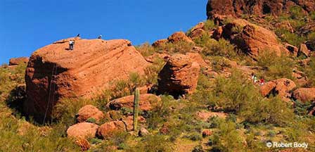
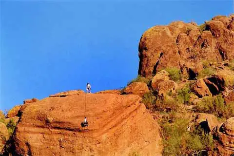 Rock Climbing on Camelback Mountain. © Robert Body
Camelback Mountain is the world-famous icon that defines the northeast horizon of Phoenix. Towering about 1,400 feet above its base, Camelback characterizes the shape of a gigantic camel that seems to admire the amazing views across the Valley below. It took nature millions and millions of years to sculpt this majestic masterpiece. Alone it sat until ancient, prehistoric Hohokam Indians settled the area only to mysteriously disappear over a thousand years ago. The Hohokam left behind a ceremonial cave on the north side of the mountain as a gift to modern civilization . What appears to be an ancient religious site is why many refer to Camelback Mountain as the 'Sacred Mountain".
The Camel sits elegantly and touches the borders of Phoenix, Scottsdale and Paradise Valley, Arizona. Its base and foothills are a quiet blend of luxury homes, resorts and golf courses that merge together to create a synergy of nature, lifestyle and outdoor recreation. It all seems to be in perfect harmony.
Urban Hiking At Its Finest
Camelback offers some of the best urban hiking in America. Conveniently located in the middle of the nation's fifth largest metropolis, it's close proximity to hotels and resorts makes it very convenient for travelers and vacationers to the area.
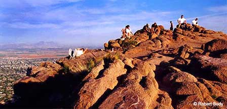
Unless you've ever hiked to the summit of Camelback, you'll never experience the quiet tranquility the spectacular beauty overlooking the cityscape . It's a magnet that attracts over 300,000 hikers every year. Many come back and do it again and again.
Since Camelback Mountain offers four different trails with varying degrees of difficulty from easy to strenuous, hikers can bite-off as much as time and skill permits. Spend less than an hour along the easy trails of Bobby's Rock Trail or the Ramada Loop Trail. Or enjoy the longer-lasting views on the Cholla Trail and even greater panoramic rewards when reaching the summit via the more strenuous Summit Trail (Echo Canyon).
The views across the cityscape are simply spectacular. You'll experience the most brilliant and colorful sunsets in the world from any of the trails, but be sure to arrive at descent before dark which is the law. Besides, the trails can become dangerous in darkness. Be safely prepared with the proper hiking gear and carry plenty of water particularly during the high temperatures of the summer months. Injuries and rescues are not uncommon where foolish hikers exceed their skill-level or roam off the marked trails.
Bobby's Rock Trail
During peak season, parking can be scarce. Follow Echo Canyon Summit Trail out of the parking lot. At the bottom of the first set of steps, it veers to the right. A trail post directs you to Bobby's Rock.
- 0.25 miles
- 200 feet
- Easy
- Sunrise to sunset
Ramada Loop Trail
Ramada Loop Trail "loops" around the upper ramada at Echo Canyon. Take the trail to the 1/8 mile marker and turn right. After looping around a small ramada and butte, it descends back to the parking lot.
- 0.125 miles
- 100 feet
- Easy
- Sunrise to sunset
Cholla Trail
No trailhead parking. Street parking limited at Invergordon and 64th Street. Hikers must walk up the south side of Cholla Lane. Cholla Trail is only recommended for experienced hikers and has steep, rocky sections with drop-offs on both sides of the trail.
- 1.5 miles
- 1,200 feet
- Strenuous
- Oct. 1 to April 30 th: 7:30 a.m-5: 30pm
May 1 to Sept 30 th: 5:30 am- 7:30 pm
Summit Trail. ( Echo Canyon)
Enter Echo Canyon Parkway east of Tatum Blvd. off of McDonald Drive. Parking is often limited. Trail ascends through spectacular sandstone rock formations and unparalled views from the summit into Greater Phoenix.
- 1.2 miles
- 1,264 feet
- 2,704 feet
- Strenuous
- Sunrise to sunset
Other Urban Hiking In Phoenix
Also see Piestewa Peak and South Mountain Park which along with Camelback Mountain, are among the most popular hiking venues in the Phoenix and Scottsdale area.
Related Phoenix Interest
Phoenix Arizona
Camelback Mountain
Desert Botanical Garden
Greater Phoenix Map
Greater Phoenix Things To Do
Japanese Friendship Garden
Mystery Castle
Hiking Papago Park
Phoenix Area Attractions
Phoenix Area Museums
Phoenix Arts & Theatre
Phoenix Bed & Breakfasts
Phoenix Boat Rentals
Phoenix Boat Tours
Phoenix Dude Ranches
Phoenix Events & Festivals
Phoenix Fishing Guides
Phoenix Grand Canyon Tours
Phoenix Horseback Riding
Phoenix Restaurants
Phoenix To South Rim
Phoenix Weather Info
Phoenix Zoo
Piestewa Peak Hiking
Rawhide Western Town
Roosevelt Lake Map & Directions
South Mountain Park
Metro Phoenix


