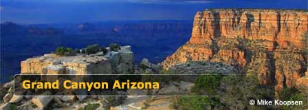
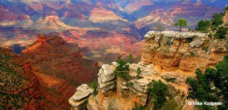
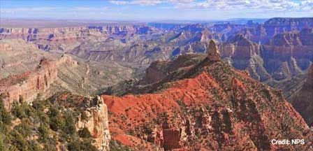
Grand Canyon National Park
Map, Directions and Travel
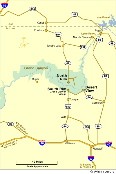
The Grand Canyon National Park includes the South Rim, North Rim and East Rim entrance at Desert View. The West Rim is not part of the Grand Canyon National Park, but is owned and operated by the Hualapai Indian Tribe on its Reservation.
Grand Canyon Map
South and North Rim Seasons
The South Rim of the Grand Canyon is open year-round, 24 hours, 365 days a year. The North Rim facilities are open only from May 15 to Mid-October.
Directions To The South Rim
The South Rim of Grand Canyon National Park is 80 to 90 miles northwest of Flagstaff, Arizona depending upon which of three different routes you take. It is approximately 60 miles north of Williams, Arizona. The Grand Canyon is located entirely within the State of Arizona.
To South Rim From Flagstaff, Arizona
1. Take I 40 West about 30 miles to Highway 64 (Exit 165) as you near Williams. Go North on Highway 64 for about 60 miles directly to the South Rim.
2. In downtown Flagstaff, travel North on Humphreys Street to Columbus Avenue which becomes Highway 180. Take Highway 180 West about 55 miles to Highway 64. Head North on Highway 64 directly to Tusayan and the South Rim.
3. Take Route 66 Northeast which will turn into Highway 89. Take Highway 89 North about 65 miles, then turn left (west) onto Highway 64 and continue directly to the East Entrance on the South Rim. The East Entrance is referred to as "Desert View". Desert View is on Desert View Drive which hugs the edge of the canyon for about 26 scenic miles to Grand Canyon Village at the South Rim.
From Williams. Take I 40 to towards Williams, Arizona which is about 33 miles east of Flagstaff. Take Highway 64 (Exit 165) North for about 60 miles directly to the South Rim. A great way to see the Grand Canyon is catching the Grand Canyon Railway in Williams.
Directions To The North Rim
Keep in mind that although you can see the North Rim from the South Rim and at some points is only about 10 miles as the bird flies to the other side, the driving distance to the North Rim from the South Rim is about 212 miles.
From Flagstaff. The one way trip from Flagstaff to the North Rim is about 207 miles (333 km). Take Highway 89 North to Highway 89A (Alt). Take 89A West to Highway 67. Take 67 South directly to the North Rim.
Directions To The Huavapai West Rim
Click here for directions to the West Rim and SkyWalk.
Convenient Hotels & Lodging
More Information
Grand Canyon National Park
Flagstaff Visitors Guide
Flagstaff Tourism Bureau
Williams Chamber of Commerce
The Spectacular Grand Canyon


