

Facts About Arizona
Reviewed and updated by AZ Leisure Staff Writers on .
Arizona is the sixth-largest state by land area and is known for the Grand Canyon, Sonoran Desert, Colorado Plateau, mountain forests and rich Indigenous and Western history. It became the 48th state on February 14, 1912, and today has an estimated population of more than 7.6 million. This guide covers Arizona’s official state symbols, geography, flag, climate records, history and other useful facts and trivia.
- Arizona Quick Facts
- Arizona State Symbols
- Arizona State Flag
- Geography and Landscape
- Arizona History Facts
- Climate and Elevation Records
- Interesting Arizona Trivia
- Frequently Asked Questions
Arizona Quick Facts
- February 14, 1912
- 48th state admitted to the United States
- Phoenix
- Phoenix
- 7,623,818
- Approximately 113,653 square miles
- Sixth-largest state by land area
- The Grand Canyon State
- Ditat Deus, meaning “God Enriches”
- Cactus wren
- Palo verde
- Ringtail
- White blossom of the saguaro cactus
- Humphreys Peak, 12,633 feet
- Colorado River near the Arizona-Mexico border, approximately 70 feet above sea level
- Mountain Standard Time in most of Arizona
Official Arizona State Symbols
Arizona has adopted numerous official symbols representing its wildlife, plants, geology, history and culture. Some of the best-known symbols are the cactus wren, palo verde tree, ringtail and white blossom of the saguaro cactus.
- State bird: Cactus wren
- State flower: White blossom of the saguaro cactus
- State tree: Palo verde
- State mammal: Ringtail
- State fish: Apache trout
- State reptile: Arizona ridge-nosed rattlesnake
- State amphibian: Arizona treefrog
- State butterfly: Two-tailed swallowtail
- State fossil: Petrified wood
- State gemstone: Turquoise
- State metal: Copper
- State dinosaur: Sonorasaurus
Arizona State Flag: Design and Meaning
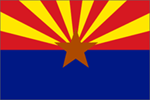
Colonel Charles W. Harris designed an early version of the Arizona flag in 1910 for the Arizona National Guard Rifle Team. The state legislature adopted the design as Arizona’s official flag in 1917.
The upper half contains 13 alternating red and yellow rays. The rays represent the original 13 colonies and the setting sun of the American West. Their red and yellow colors reflect colors associated with the Spanish expeditions that entered the region during the 1500s.
The lower half is a blue field matching the blue of the United States flag. A large copper-colored star in the center represents Arizona’s historic importance as a copper-producing state.
Arizona Geography and Landscape
Arizona covers approximately 113,653 square miles of land, making it the sixth-largest state by land area. Its scenery is far more varied than its desert reputation suggests. The state includes low-elevation Sonoran Desert valleys, the Mogollon Rim, the Colorado Plateau, deep canyons, volcanic fields, grasslands and extensive mountain forests.
Elevation ranges from roughly 70 feet near the Colorado River at the Mexican border to 12,633 feet at Humphreys Peak north of Flagstaff. This elevation range creates major differences in climate, vegetation and seasonal weather across the state.
- Southern and central Arizona: Sonoran Desert, mountain ranges and broad valleys
- Northern Arizona: Colorado Plateau, Grand Canyon and high-desert landscapes
- Central high country: Mogollon Rim, forests, lakes and mountain communities
- Western Arizona: Colorado River, desert lakes and rugged mountain terrain
- Eastern Arizona: White Mountains, grasslands and high-elevation forests
Arizona History Facts
Arizona became a United States territory in 1863 and was admitted to the Union on February 14, 1912. Its statehood date is the reason Arizona is often called the Valentine State, although the Grand Canyon State remains its official and best-known nickname.
- Indigenous peoples have lived in the region for thousands of years.
- Spanish expeditions entered the area during the 1500s.
- Arizona was part of Mexico before becoming United States territory.
- The Gadsden Purchase of 1853 added land that now forms part of southern Arizona.
- Arizona Territory was established in 1863.
- Phoenix became the permanent territorial capital in 1889.
- Arizona entered the Union as the 48th state on February 14, 1912.
- The historic London Bridge was reconstructed at Lake Havasu City and dedicated there in 1971.
Arizona Climate and Elevation Records
Arizona’s climate varies greatly with elevation. Low-desert communities experience extremely hot summers and mild winters, while the state’s mountain regions receive freezing temperatures, heavy snow and much cooler summer weather.
- Highest recorded Arizona temperature: 128°F at Lake Havasu City on June 29, 1994
- Lowest recorded Arizona temperature: -40°F at Hawley Lake on January 7, 1971
- Highest natural point: Humphreys Peak at 12,633 feet
- Lowest point: Colorado River near the Mexican border at approximately 70 feet
- Primary desert rainy season: Summer monsoon, generally during July through September
- Snowiest regions: High elevations near Flagstaff, the Mogollon Rim and the White Mountains
Interesting Arizona Facts and Trivia
- Arizona became a state on Valentine’s Day in 1912.
- The Grand Canyon is more than 270 river miles long.
- Humphreys Peak is Arizona’s highest point at 12,633 feet.
- Arizona contains parts of four major deserts: the Sonoran, Mojave, Chihuahuan and Great Basin deserts.
- The saguaro cactus grows naturally only in the Sonoran Desert.
- The white saguaro blossom became Arizona’s official state flower in 1931.
- The ringtail is Arizona’s state mammal, even though it is commonly called a ringtail cat and is more closely related to raccoons.
- Arizona does not observe daylight saving time in most of the state, although the Navajo Nation does.
- The state flag contains 13 red and yellow rays representing the original colonies.
- Copper is Arizona’s official state metal and is represented by the copper star on the state flag.
- Petrified wood is Arizona’s official state fossil.
- London Bridge was dismantled in England and reconstructed at Lake Havasu City.
- Arizona contains national parks ranging from the Grand Canyon to saguaro forests and petrified woodlands.
- The Colorado River forms much of Arizona’s western boundary.
- Arizona’s elevation range allows both desert cactus and alpine plants to grow within the same state.
Frequently Asked Questions About Arizona
When did Arizona become a state?
Arizona became the 48th state on February 14, 1912. Because it entered the Union on Valentine’s Day, it is sometimes informally called the Valentine State.
What is the capital of Arizona?
Phoenix is the capital and largest city of Arizona.
What is Arizona’s population?
The U.S. Census Bureau estimated Arizona’s population at 7,623,818 on July 1, 2025.
What is Arizona’s nickname?
Arizona’s official nickname is the Grand Canyon State.
What is Arizona’s state motto?
Arizona’s state motto is Ditat Deus, a Latin phrase meaning “God Enriches.”
What is Arizona’s state bird?
The cactus wren is Arizona’s official state bird. It is commonly found in desert scrub and frequently nests in cholla cactus and other thorny vegetation.
What is Arizona’s state flower?
The official state flower is the white blossom of the saguaro cactus. The flowers generally appear during May and June.
What is Arizona’s state tree?
The palo verde is Arizona’s state tree. Its Spanish name means “green stick,” referring to its green bark.
What is Arizona’s state mammal?
The ringtail is Arizona’s official state mammal. It is sometimes called a ringtail cat, but it is related to raccoons rather than domestic cats.
How large is Arizona?
Arizona has approximately 113,653 square miles of land, making it the sixth-largest state by land area.
What is the highest point in Arizona?
Humphreys Peak, north of Flagstaff, is Arizona’s highest point at 12,633 feet above sea level.
Does Arizona observe daylight saving time?
Most of Arizona remains on Mountain Standard Time throughout the year. The Navajo Nation observes daylight saving time.
What is Arizona best known for?
Arizona is best known for the Grand Canyon, Sonoran Desert, saguaro cactus, red-rock landscapes, Indigenous cultures, Old West history and diverse mountain and desert scenery.
Official Arizona Facts and Resources
- Arizona State Library: Official State Symbols
- U.S. Census Bureau: Arizona QuickFacts
- Arizona Secretary of State: Great Seal and State Motto
- National Weather Service: Arizona Temperature Records
Most Popular Things To Do In AZ
Additional Arizona Activities















