
Jerome Arizona Map & Directions
Last updated on .
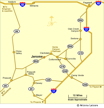
The Jerome Arizona map provides a clear overview of this historic hillside town and its surrounding attractions in the Verde Valley. Located along State Route 89A between Sedona and Prescott, Jerome sits high on Cleopatra Hill overlooking miles of scenic desert and mountain landscapes. This map helps visitors visualize the town’s layout, including key streets, historic sites, scenic overlooks, and nearby destinations, making it easier to plan a visit to one of Arizona’s most unique travel locations.
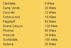
There are just a few ways to get to Jerome, Arizona and the directions are dependent upon your origination point. Jerome is located between Prescott and Sedona, and within very close driving distance to its neighbors of Clarkdale and Cottonwood, Arizona. See the distance chart below which shows the number of miles from Jerome to other towns and cities.
Popular Locations Near Jerome Arizona
Jerome’s central location makes it easy to explore several nearby attractions within a short drive. Visitors can head east to Sedona’s red rock country, explore the wineries and shops of Cottonwood and Clarkdale, or visit historic and cultural sites throughout the Verde Valley. The town itself is compact and walkable, allowing visitors to park once and explore its galleries, museums, and scenic viewpoints on foot. With its proximity to multiple destinations, Jerome is an ideal stop on a northern Arizona road trip.
 Map Directions To Jerome AZ
Directions To Jerome Arizona
From Sedona. Jerome is less than 28 miles southwest of Sedona AZ. Take State Route 89A to Cottonwood, then through Clarkdale into Jerome. This is very scenic drive.
From Prescott. Jerome is less than 35 miles northeast of Prescott. It is below Mingus Mountain so expect some hairpin turns as you descend into Jerome. Take State Route 89 for about 7 miles to State Route 89A. Turn right of 89A and drive up and then down Mingus Mountain for about 27 miles into Jerome, Arizona.
From Flagstaff. Get ready for one of the most scenic drives you will ever experience. Take State Route 89A southwest through Oak Creek Canyon into Sedona, then see the directions from Sedona above. The total miles from Flagstaff to Jerome is about 56 miles.
From Phoenix and Scottsdale. Expect about 2 to 2.5 hours drive time depending upon your origination point. Take Interstate 17 Freeway north and exit at State Route 260 at Camp Verde. Go left (northwest) on 260 into Cottonwood and then left on 89A through Clarkdale into Jerome AZ.
Best Scenic Routes To Jerome
Jerome is best reached by scenic Arizona highways that pass through red rock country, mountain curves, historic mining areas, and Verde Valley communities. State Route 89A is the most important road for visitors, connecting Jerome with Sedona, Cottonwood, Clarkdale, and Prescott. Drivers should expect curves, elevation changes, and slower travel near Mingus Mountain and Jerome’s hillside streets.
- From Sedona: Take State Route 89A through Cottonwood and Clarkdale for a scenic Verde Valley drive.
- From Prescott: Follow State Route 89A over Mingus Mountain for mountain views and winding roads.
- From Flagstaff: Drive through Oak Creek Canyon and Sedona before continuing toward Jerome.
- From Phoenix: Use Interstate 17 north to State Route 260, then continue through Cottonwood to Jerome.
Things To See Near Jerome
Jerome is close to several popular Verde Valley attractions, making it easy to include the town as part of a full-day northern Arizona trip. Visitors often combine Jerome with Cottonwood, Clarkdale, Tuzigoot National Monument, Verde Canyon Railroad, Sedona, or Prescott. The compact historic district, hillside views, shops, galleries, and old mining landmarks make Jerome a memorable stop along the route.
- Cottonwood: Nearby shops, restaurants, wine tasting rooms, and historic Old Town Cottonwood.
- Clarkdale: Home to the Verde Canyon Railroad and close to Tuzigoot National Monument.
- Sedona: Famous red rock scenery less than an hour from Jerome.
- Prescott: Historic downtown, Whiskey Row, lakes, and mountain scenery west of Jerome.
- Mingus Mountain: Scenic high-country views along the route between Prescott and Jerome.

Interactive Jerome Arizona Map
View Larger Map
Driving Distance From Jerome
The following mileage chart shows the number of miles from Jerome to other Arizona towns and cities. Click on the other destinations to discover tourist attractions and points of interest in those respective vacation destinations. The Verde Canyon Railroad is just 6 miles from Jerome in Clarkdale, Arizona.
Return to Jerome Arizona Home Page.
FAQ
Where is Jerome Arizona located?
Jerome is located in central Arizona in the Verde Valley, along State Route 89A between Sedona and Prescott.
What is the main road to Jerome Arizona?
State Route 89A is the main road to Jerome, connecting the town with Sedona, Cottonwood, Clarkdale, and Prescott.
How far is Jerome from Sedona?
Jerome is less than 28 miles southwest of Sedona by way of State Route 89A through Cottonwood and Clarkdale.
How far is Jerome from Prescott?
Jerome is less than 35 miles northeast of Prescott by way of State Route 89A over Mingus Mountain.
How far is Jerome from Flagstaff?
Jerome is about 56 miles from Flagstaff when traveling through Oak Creek Canyon, Sedona, Cottonwood, and Clarkdale.
How long does it take to drive from Phoenix to Jerome?
The drive from Phoenix or Scottsdale to Jerome usually takes about 2 to 2.5 hours, depending on traffic and the starting point.
Is the drive to Jerome scenic?
Yes. The drive to Jerome is very scenic, especially along State Route 89A through Oak Creek Canyon, the Verde Valley, and Mingus Mountain.
What attractions are near Jerome?
Nearby attractions include Cottonwood, Clarkdale, Verde Canyon Railroad, Tuzigoot National Monument, Sedona, Prescott, and Mingus Mountain.
Related Jerome Interest
Jerome Arizona
Article About Jerome AZ
Jerome Bed & Breakfasts
Jerome Photos
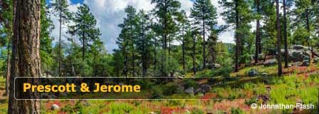
In The Pines Around Prescott
Prescott Arizona
Map & Directions
Prescott Arizona
Average Temperatures
About Prescott AZ
Jerome Area Map
Jerome Arizona
Lakes Nearby Prescott
Watson Lake
Goldwater Lake
Lynx Lake
Willow Lake
Things To Do
Camping In Prescott
Prescott Lakes
Prescott Attractions
Prescott Golf Courses
Prescott Hiking
Prescott Museums
Nearby Camping
White Spar Campground
Lynx Lake Campground
Granite Group Camping
Hilltop Campground
Lower Wolf Creek
Upper Wolf Creek
Where To Stay
Prescott Cabin Rentals
Bed & Breakfast
Prescott RV Parks
Prescott Articles
History Lives In Prescott
Whiskey Row


