


Parsons Trail #144 In Sycamore Canyon Wilderness
Reviewed and updated by AZ Leisure Staff Writers on .
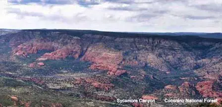
Parsons Trail #144 enters the southern end of Sycamore Canyon Wilderness northwest of Cottonwood and Clarkdale, Arizona. The trail descends about 180 feet from the trailhead to Sycamore Creek, then follows the canyon upstream through a lush riparian corridor shaded by cottonwood, willow, ash and box elder trees.
The hike to Parsons Spring is approximately 4 miles one way, making the full out-and-back route about 8 miles. Much of the trail is relatively gentle after the initial descent, but hikers should still be prepared for creek crossings, uneven terrain, summer heat, wilderness conditions and the climb back to the trailhead at the end of the day.
- Parsons Trail Quick Facts
- What The Hike Is Like
- Parsons Spring
- Creek Crossings & Water
- Camping
- Best Time To Hike
- Safety & Trail Conditions
- Trail Map
- Directions To The Trailhead
- Hiking Tips
- FAQ
Parsons Trail #144 Quick Facts
- Trail: Parsons Trail #144
- Location: Southern Sycamore Canyon Wilderness near Cottonwood and Clarkdale
- Distance: Approximately 8 miles round trip to Parsons Spring
- One-way distance: Approximately 4 miles
- Trailhead elevation: About 3,760 feet
- Initial descent: Approximately 180 feet
- Accumulated elevation gain: Roughly 600 feet round trip
- Typical hiking time: About 4 to 6 hours, depending on pace and stops
- Water: Perennial creek and springs may be present, but all natural water must be treated
- Motorized/mechanized use: Not permitted inside designated wilderness
What The Parsons Trail Hike Is Like
After descending from the trailhead, Parsons Trail follows Sycamore Creek through one of the most scenic riparian corridors in the lower canyon. Large cottonwoods and other shade trees create cool pockets along the creek, while red sandstone, pale limestone and darker volcanic rock form the canyon walls above.
The trail crosses the creek several times and occasionally climbs onto short benches above the water before dropping back into the riparian zone. Vegetation changes noticeably between the shaded creek bottom and the warmer, drier slopes above it.
Parsons Spring
Parsons Spring is the traditional turnaround point for most day hikers and lies about 4 miles from the trailhead. Along the way, smaller springs and lush vegetation can appear along the canyon walls, including watercress and seasonal wildflowers.
Parsons Spring emerges near a large pool in the canyon bottom and creates one of the most memorable areas along the hike. Surface-water conditions can vary with season, snowmelt and monsoon activity.
Shaded areas near Parsons Spring provide a good place to rest before beginning the return hike. Some visitors wade or swim where water conditions are suitable, but depths, current, submerged rocks and debris can change after storms. Avoid jumping from rocks or cliffs into water unless you can independently verify that conditions are safe.
Creek Crossings & Water
Parsons Trail crosses Sycamore Creek several times. Crossing difficulty varies with recent rain, snowmelt and seasonal flow, so hikers should be prepared for wet feet and changing conditions.
Do not rely on creek or spring water as safe drinking water. Carry enough water for the hike and treat or filter any natural water before drinking it.
Parsons Trail Statistics & Guidelines
- Difficulty: Moderate overall; relatively gentle creek-bottom hiking after the initial descent
- Distance: Approximately 8 miles round trip
- Typical hiking time: About 4 to 6 hours
- Trailhead elevation: Approximately 3,760 feet
- Initial elevation change: About 180 feet down to the canyon bottom
- Accumulated gain: Approximately 600 feet round trip
- Services: None at the trail; carry food and drinking water
- Wilderness rules: Motorized and mechanized equipment are prohibited
- Use level: Popular during spring and fall
- Primary feature: Sycamore Creek and Parsons Spring
Camping Along Parsons Trail
Backpacking is possible in Sycamore Canyon Wilderness, but camping restrictions apply along the heavily used lower portion of Parsons Trail. Hikers planning an overnight trip should verify current Coconino National Forest camping rules before departure and choose established, low-impact sites where camping is permitted.
Practice Leave No Trace principles, pack out all trash and avoid creating new fire rings or campsites in sensitive riparian areas.
Best Time To Hike Parsons Trail
- Spring: March through May generally brings comfortable temperatures, flowing water and wildflowers.
- Summer: Temperatures in the lower canyon can approach or exceed 100°F, and monsoon storms can create flash-flood hazards.
- Fall: September through November usually provides excellent hiking temperatures and colorful riparian vegetation.
- Winter: Hiking is possible, but mornings can be cold and shaded sections of the canyon may remain chilly.
Parsons Trail Safety & Conditions
- Check weather forecasts before entering Sycamore Canyon.
- Avoid the canyon when heavy rain or flash flooding is possible.
- Carry sufficient drinking water even though the trail follows a creek.
- Treat or filter all natural water before drinking.
- Expect several creek crossings and potentially wet footing.
- Use extra caution during summer heat.
- Remember that the return hike finishes with the climb back to the trailhead.
- Cell-phone coverage may be limited or unavailable in the canyon.
- Tell someone your route and expected return time before hiking.
- Check current Forest Service alerts, road conditions and fire restrictions before leaving.
Parsons Trail Video
Parsons Trail Location Map
The Parsons Trailhead is reached from the Cottonwood and Clarkdale area on Forest Road 131. The trailhead is approximately 33 miles from Sedona and about 76 miles from Flagstaff by road.

Directions To Parsons Trailhead
From Cottonwood or Clarkdale, follow signs toward Tuzigoot National Monument. After crossing the Verde River, turn onto Sycamore Canyon Road, which becomes Forest Road 131, and continue toward the southern end of Sycamore Canyon Wilderness.
The Forest Road 131 approach is unpaved for much of the drive. Passenger cars can generally reach the trailhead when conditions are dry, but the road becomes rougher near the end and high-clearance vehicles are preferable. Avoid the road during or immediately after heavy rain when mud, washouts or creek crossings may create problems.
Parsons Trail Hiking Tips
- Start early during warm weather.
- Carry more drinking water than you expect to need.
- Wear shoes suitable for creek crossings and uneven terrain.
- Bring sun protection for exposed sections above the creek.
- Use insect repellent during warmer months.
- Do not assume natural water is safe to drink untreated.
- Pack out all trash and food waste.
- Avoid trampling vegetation near springs and creek banks.
- Allow extra time for stops at Parsons Spring.
- Remember that the final climb back to the trailhead comes at the end of the hike.
Parsons Trail FAQ
How Long Is Parsons Trail?
The hike from Parsons Trailhead to Parsons Spring is approximately 4 miles one way, or about 8 miles round trip.
Is Parsons Trail Difficult?
The creek-bottom portion is relatively gentle, but the full hike is best considered moderate because of the 8-mile distance, creek crossings, wilderness conditions and the climb back to the trailhead.
How Long Does It Take To Hike Parsons Trail?
Most hikers should allow roughly 4 to 6 hours for the full round trip, depending on pace, creek crossings and time spent at Parsons Spring.
Is There Water On Parsons Trail?
Sycamore Creek and several springs can provide surface water, but availability and flow vary. Carry your own drinking water and treat any natural water before drinking.
Can You Swim At Parsons Spring?
Visitors sometimes wade or swim where conditions are suitable, but water depth, current and submerged hazards can change. Use caution and avoid jumping from rocks into unknown water.
Can You Camp Along Parsons Trail?
Backpacking is possible in Sycamore Canyon Wilderness, but camping restrictions apply along portions of the trail. Check current Coconino National Forest rules before an overnight trip.
Are Dogs Allowed On Parsons Trail?
Dogs may accompany hikers where current Forest Service regulations allow, but owners should keep them under control, carry water for them and be prepared for heat and creek crossings.
Can A Passenger Car Reach Parsons Trailhead?
The Forest Road 131 approach is generally passable by passenger cars when dry, but the final miles are rougher and high-clearance vehicles are preferable.
What Is The Best Time To Hike Parsons Trail?
Spring and fall generally provide the most comfortable temperatures. Summer can be extremely hot and monsoon storms can create flash-flood hazards.
More Sycamore Canyon & Verde Valley Information
- Sycamore Canyon Wilderness
- Cottonwood Arizona
- Sedona & Oak Creek Canyon
- Verde Canyon Railroad
- Montezuma Castle National Monument
- Montezuma Well
Coconino National Forest Recreation Information
Check the official Forest Service website for current trail alerts, road conditions, fire restrictions and wilderness regulations before hiking Parsons Trail.
The Wonder Of Sedona & Oak Creek
Sedona-Oak Creek Canyon
Sedona Arizona
Oak Creek Canyon
Arizona Route 66
Map & Directions
Weather & Climate
Sedona Pictures
Things To Do
Public Golf Courses
Grand Canyon Tours
West Fork Trail
Desert Canyon Drive
Sedona Museums
Events & Festivals
Horseback Riding
Area Attractions
Palatki Indian Ruins
Montezuma Castle
Montezuma Well
Grand Canyon South Rim
Sycamore Canyon
Slide Rock State Park
Grand Canyon Railway
Chapel of the Holy Cross
Oak Creek
Nearby Towns
Flagstaff Arizona
Jerome Arizona
Cornville Arizona
Williams Arizona
Cottonwood Arizona
Sedona Articles
Native American History
Vortex Visions
Mystical Vortexes
Enchantment Resort
Credit The Sinagua
Where To Stay
Cabins & Lodges
RV Parks & Campgrounds
Bed and Breakfast
Sedona Vacation Rentals
Sedona Timeshares















