

Wupatki National Monument
Last updated on .
Explore Wupatki National Monument Near Flagstaff
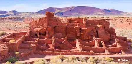
Wupatki National Monument near Flagstaff, Arizona preserves some of the most impressive ancient pueblo ruins in the Southwest. Located in the high desert landscape north of Flagstaff, the monument features large Sinagua and Ancestral Puebloan structures built more than 800 years ago. Visitors can explore scenic walking trails, historic stone pueblos, volcanic landscapes, and panoramic views while learning about the Native cultures that once thrived in this rugged region of Northern Arizona.

Thousands of years ago, ancient native people settled in an area just north of Flagstaff Arizona in a place we know today as Sunset Crater Volcano. These people were given the name "Sinagua Indians". They grew corn in the area under some extreme conditions of both drought and torrential rains and grazed their animals in open meadows. In about 1100AD the Sunset Volcano erupted spreading heavy layers of volcanic ash destroying agricultural lands.
Why Visit Wupatki National Monument
People visit Wupatki National Monument to experience ancient Native American history, dramatic desert scenery, and well-preserved pueblo ruins all within a short drive of Flagstaff. The monument offers an easy combination of history, photography, sightseeing, hiking, and scenic driving. Many travelers also combine a visit with nearby attractions including Sunset Crater Volcano National Monument, the Painted Desert, Walnut Canyon, and the San Francisco Peaks Scenic Area.
Groups of the ancient Sinaguans migrated relatively short distances and created new settlements in both the Walnut Canyon area and to the area we know today as the Wupatki National Monument which is located a very short distance north of Flagstaff, Arizona.
Things To Do & See Around Wupatki National Monument
- Explore Wupatki Pueblo: Walk the paved trail through the monument's largest and most famous pueblo ruin.
- Visit Wukoki Pueblo: See one of the best-preserved multi-story stone pueblos in Northern Arizona.
- Drive the Scenic Loop Road: Enjoy dramatic desert scenery between Wupatki and Sunset Crater Volcano.
- Tour Sunset Crater Volcano: Discover volcanic landscapes created by eruptions that helped shape the area's history.
- Photograph Ancient Ruins: Capture striking images of stone pueblos against colorful desert backdrops.
- Visit the Wupatki Visitor Center: Learn about Sinagua culture, archaeology, and regional history through exhibits and displays.
- Explore Citadel Pueblo: Hike to the hilltop ruins overlooking the surrounding desert plains.
- See Native American Petroglyphs: Look for ancient rock carvings and cultural features along designated trails.
- Enjoy Desert Wildlife Viewing: Watch for ravens, hawks, lizards, pronghorn, and other high desert wildlife.
- Combine With Nearby Attractions: Visit Walnut Canyon, Flagstaff, the Painted Desert, or the San Francisco Peaks during the same trip.
Best Times To Visit Wupatki National Monument
- Spring: Mild temperatures and blooming desert plants make spring one of the best seasons for hiking and sightseeing.
- Summer: Morning visits are ideal due to warmer afternoon temperatures and seasonal thunderstorms.
- Fall: Cooler temperatures and clear skies provide excellent weather for photography and scenic drives.
- Winter: Snow occasionally dusts the surrounding landscape creating unique views of the ancient pueblos and nearby peaks.
Photography at Wupatki National Monument
Wupatki National Monument is one of the most photogenic archaeological destinations in Arizona. Early morning and late afternoon lighting often provide the best conditions for photographing the red stone pueblos, volcanic terrain, desert grasslands, and distant San Francisco Peaks. Wide landscape views and historic architectural details make the monument especially popular with photographers exploring Northern Arizona.
Wupatki Picture Gallery
These photographs showcase ancient pueblo ruins, scenic desert landscapes, historic stone structures, and panoramic views throughout Wupatki National Monument near Flagstaff, Arizona.


These photos are compliments of several photographers that permitted the use of these pictures and images of the Wupatki Ruins under the Creative Commons License.
Nearby Attractions Around Wupatki National Monument
- Sunset Crater Volcano National Monument: Scenic volcanic landscapes and lava flow trails located along the same loop road.
- Walnut Canyon National Monument: Ancient cliff dwellings built into steep canyon walls near Flagstaff.
- Painted Desert: Colorful desert scenery and panoramic overlooks east of Flagstaff.
- Flagstaff Arizona: Popular mountain town offering lodging, restaurants, shopping, and outdoor recreation.
- San Francisco Peaks: Northern Arizona mountain range known for scenic drives, hiking, and winter snow.
How The Ancient Pueblo Ruins Came To Be
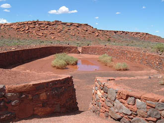
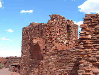
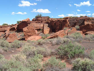
In groups, the Sinagua Indians built separate Pueblo Villages in Wupatki of which the largest was Wupatki Pueblo which was occupied by about 85 to 100 natives. Other Pueblo Villages are Nalakihu, Citadel, Lomaki and Wukoki Pueblos.
Sinagua, a name given by the Spanish means "Sin" (without) and "agua" (water) which combined means "without water". They were agricultural people as well as gifted artisans as evidenced by artifacts left behind. Agriculture seemed to thrive in their new home because the "thinner layers" of volcanic distributed by the eruption of the nearby Sunset Crater Volcano enriched the soil improving moisture retention.
The Sinaguans established trade with other ancient peoples along trade routes, exchanging agricultural products for other goods including precious stones and shell jewelry. For still undetermined mysterious reasons, the Sinagua left the area in about 1250AD.
Today's Hopi and Navajo Indian tribes are believed by many to be descendants of the Sinagua. No doubt, ceremonies and tribal rituals have been handed down over centuries. Crafts, pottery and weavings today are deeply rooted in the past. The ancient Sinagua not only gifted customs to their descendants but also left these well-preserved rock-formed Pueblo dwellings in the Wupatki National Monument as evidence of their existence.
Experiencing Ancient Pueblo History at Wupatki National Monument
Wupatki National Monument is located approximately 30 miles north of Flagstaff, AZ in the picturesque high desert region just west of the Little Colorado River and the Navajo Indian Reservation. At an elevation of about 7,000 feet, the high desert label belies the traditional image of chaparral and bedrock. Lush ponderosa pines and the snow-capped San Francisco Peaks greet visitors to this archaeological and historic wonderland.
Visitors and vacationers to Wupatki can explore the ruins of the pueblos, examine unique flora that flourishes in the area, walk among the trails used by early agriculturists and experience what life must have been like for these ancient natives almost a thousand years ago.
Visiting and Hiking The Pueblo Villages
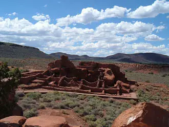
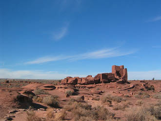
Encompassing 56 square miles, the Wupatki National Monument is home to several remaining pueblos.
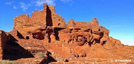
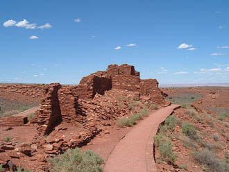
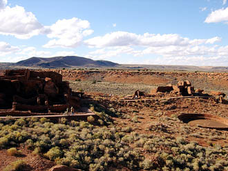
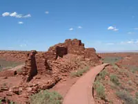
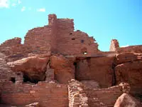
Wupatki Pueblo
Namesake Wupatki Pueblo is the largest pueblo in the Monument. Accessed via a trail located directly behind the Visitor Center, the pueblo was once home to about 100 people. Thousands more lived within a day's walk of the pueblo and one of the pueblos most prominent features is the community room, a gathering place where early inhabitants undoubtedly met to discuss trade and local community affairs. The Wupatki Pueblo Trail is a � mile round trip hike that is rated easy to moderate to navigate. The trail is paved and accessible up to an outlook that looks down on the open areas of the pueblo, including the community room.
Citadel Pueblo
Resembling a fortress at the top of a hill, the Citadel pueblo is located nine miles northwest of the Wupatki Visitor Center just off a paved road. Once housing 30 rooms, the ruins rise about the remains of ten other pueblo buildings scattered below the Citadel. Along the path to the pueblo are the ruins of Nalakihu, a Hopi word for "House Standing Outside the Village."
Lomaki Pueblo
Lomaki is Hopi for "beautiful house" and when you stand amidst her stacked stone walls gazing through uniform windows across the plains, it is understandable how the Hopi people could conceive of such a fitting name. Located about a half mile past the Citadel ruins northwest of the Visitor Center, the Lomaki pueblo is a stunning setting that should not be missed.
Wukoki Pueblo
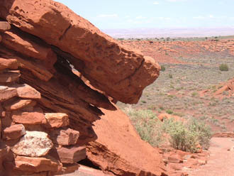
Perhaps the best preserved of all the pueblos, Wukoki still stands three stories tall and has pieces of wood beam remaining. Located 3 miles from the Visitor Center, Wukoki can be reached by driving a ¼ mile back toward Sunset Crater, then 2½ miles up a paved road.
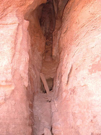
Crack-in-the-Rock Pueblo
The more adventuresome will love Crack-in-the-Rock pueblo, located at the end of a ranger-led backpacking trip during the spring and summer months. Hikers will be rewarded with stunning views of the Little Colorado River in the distance, several smaller pueblos along the way and numerous petroglyphs carved into the stone walls at the base of Crack-in-the-Rock. A moderately difficult 14 mile round trip, adventure-seekers wanting the ultimate pueblo experience can contact the Visitor Center for more information (see below).
Discover the Wupatki Pueblos
When visiting any of the pueblos it is important to stay on designated paths and not climb on the walls. Discovery Packs are available at the Wupatki National Monument Visitor Center and offer exciting tools to enhance your experience at the Monument. Inside you will find binoculars for enjoying far away vistas from pueblo to pueblo and a magnifying lens for close up examination of the pottery, stonework and archaeological remains. There are field guides about the plants, flowers and landscape that remain, drawing paper and pencils to capture your visual impressions, and a Field Journal to record all your observations and experiences. Use your Discovery Pack to enhance your visit to the Pueblos, leaving the buildings and ruins undisturbed for others to visit, study and enjoy for the next thousands of years.
Available at the Visitor Center, Discovery Packs are designed to be used not only at Wupatki, but also at nearby Walnut Canyon and Sunset Crater Volcano National Monuments as well. At the end of your visit, just return the Discovery Pack to the Visitor Center, taking your Field Journal home as a reminder of the exciting things you saw along the way. Families will especially enjoy the Discovery Pack however anyone with a sense of adventure or a curiosity about nature will be pleased as well. There is no charge for borrowing a Discovery Pack.
Weather At Wupatki Ruins
The climate is generally similar but warmer to that of Flagstaff, Arizona Weather. During late spring and the summer months, the high temperatures often run from about 70 degrees F to sometimes in the high-90 degrees F range. Late fall can become cool and the winter season often brings heavy snow. Short afternoon thunderstorms are common during July through September.
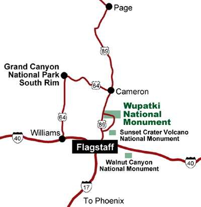
Getting to Wupatki National Monument
The entrance to Wupatki National Monument is located about 15 miles north of Flagstaff, AZ. Take US 89 north for 12 miles. Turn right at the sign for Sunset Crater Volcano - Wupatki National Monuments onto the Loop Road. Once you pass the Sunset Crater Volcano travel another 19 miles, enjoying the scenic climb from 5,000 feet to Wupatki's 7,000 foot elevation. See more photographs of Wupatki National Monument.
The Monument is open every day of the year. The Visitor Center is open 9:00 AM to 5:00 PM year- round except for Christmas Day.
Latitude: 35.5578
Longitude: -111.4010
Map To Wupatki
FAQ
Where is Wupatki National Monument located?
Wupatki National Monument is located about 30 miles north of Flagstaff, Arizona along the scenic loop road connecting Wupatki and Sunset Crater Volcano National Monument.
How long does it take to visit Wupatki National Monument?
Most visitors spend between two and four hours exploring the pueblos, visitor center, scenic overlooks, and nearby attractions.
Is Wupatki National Monument good for families?
Yes. The monument offers short walking trails, educational exhibits, scenic viewpoints, and easy access to several ancient pueblo ruins.
Can you hike at Wupatki National Monument?
Yes. Several easy walking trails lead to pueblo ruins and scenic viewpoints throughout the monument.
What is the best time of year to visit Wupatki National Monument?
Spring and fall usually provide the most comfortable weather for sightseeing, hiking, and photography.
Is Wupatki National Monument near Sunset Crater Volcano?
Yes. The two national monuments are connected by a scenic driving loop and are commonly visited together.
For More Information
Wupatki National Monument
Visitor Center
(928) 679-2365
Indian Ruins In Arizona
Arizona Indian Ruins
Canyon de Chelly
Casa Grande Ruins
Montezuma Castle
Map & Directions Montezuma Castle
Montezuma Well
Palatki Indian Ruins
Pueblo Grande
Walnut Canyon
Wupatki Ruins


