
Blue Ridge Reservoir Near Payson AZ
Last updated on .
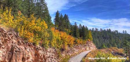
Blue Ridge Reservoir is one of the most scenic lakes in Arizona, known for its steep canyon walls, clear water, and excellent kayaking and trout fishing along the Mogollon Rim.
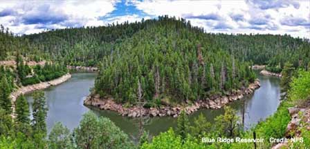
 Blue Ridge Reservoir. © Kevin Dooley
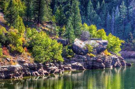
Blue Ridge Reservoir is one of Arizona’s most scenic and unique lakes, located along the Mogollon Rim near Payson. Known for its steep canyon walls, clear waters, and cool temperatures, this long, narrow reservoir offers a striking contrast to typical desert lakes. Surrounded by forest and accessible by boat or a short hike, Blue Ridge Reservoir is a favorite destination for kayaking, fishing, and exploring one of the most beautiful waterways in central Arizona.
Only one way to describe Blue Ridge Reservoir. Strikingly beautiful. Located about midway between Payson and Flagstaff on the Mogollon Rim in the Coconino National Forest. Surrounded by thick forest Blue Ridge is narrow, long and deep. It's more like a winding, canyon-bound river than a lake. A favorite activity here is kayaking Blue Ridge Reservoir. One thing for sure, it is one of the more picturesque places in Arizona.
Why Visit Blue Ridge Reservoir
Visitors are drawn to Blue Ridge Reservoir for its dramatic scenery and peaceful environment. The lake’s limited access helps maintain a quiet, uncrowded atmosphere, making it ideal for kayaking, canoeing, and fishing. Anglers target trout and smallmouth bass, while outdoor enthusiasts enjoy the remote setting and unique canyon landscape. Avid anglers especially enjoy trout fishing Blue Ridge Reservoir.
This is high country at about 6,700 feet and somewhat remote making it likely to be uncrowded even during peak season. This is one of the top Mogollon Rim lakes in Arizona for tranquility and solitude. It is great for kayaking and canoeing. Although about equal distance for Payson and Flagstaff, AZ, the closest small community id Happy Jack, where there is an information center.
Things To Do At Blue Ridge Reservoir
- Kayaking & Canoeing: Paddle through narrow canyon passages and explore one of Arizona’s most scenic waterways.
- Trout Fishing: Fish for rainbow, brown, and brook trout in deep, clear water.
- Hiking: Access shoreline areas and scenic overlooks via short forest trails.
- Wildlife Viewing: Watch for elk, deer, and birds along the canyon and forest edges.
- Photography: Capture dramatic canyon walls and reflective water views.
Season. Open as weather permits. Closed during the winter.
Fishing At Blue Ridge Reservoir
Fishing at Blue Ridge Reservoir is known for its clear water and strong trout population. The reservoir supports rainbow trout, brown trout, and brook trout, making it one of the more diverse trout fisheries along the Mogollon Rim.
- Rainbow Trout: Commonly stocked and widely targeted by anglers.
- Brown Trout: Found throughout the reservoir and often grow to larger sizes.
- Brook Trout: Add variety to the fishing experience.
- Best Fishing Times: Spring and fall offer the most consistent fishing conditions.
- Boat & Shore Access: Fishing is productive from both boats and accessible shoreline areas.
Boating & Kayaking At Blue Ridge Reservoir
Blue Ridge Reservoir is one of the best kayaking destinations in Arizona due to its calm water and narrow canyon layout. The reservoir stretches through scenic rock walls, creating a unique paddling experience unlike most lakes in the state.
- Motor Limit: Boats are limited to 10 horsepower.
- Best Watercraft: Kayaks, canoes, and small fishing boats are ideal.
- Boat Ramp: Available near the main access area.
- Canyon Exploration: Paddle deep into the canyon for quiet water and scenic views.
Camping At Blue Ridge Reservoir
Rock Crossing Campground is the primary camping area near Blue Ridge Reservoir, offering a forest setting with access to the lake and nearby trails.
- Rock Crossing Campground: Offers developed campsites with tables, fire rings, and grills.
- Amenities: Drinking water and vault toilets are available.
- Season: Typically open from late spring through mid-fall.
- Trail Access: Scenic trails connect the campground to the reservoir.
Best Time To Visit Blue Ridge Reservoir
- Spring: Excellent fishing and comfortable temperatures.
- Summer: Ideal for kayaking and escaping the desert heat.
- Fall: Cooler weather and fewer crowds make this a great time to visit.
- Winter: Access is typically limited due to snow and road closures.
Tips For Visiting Blue Ridge Reservoir
- Arrive Early: Parking and access can be limited during peak season.
- Bring Supplies: Services are limited near the reservoir.
- Check Road Conditions: Forest roads may be rough or muddy after storms.
- Plan for Weather: Conditions can change quickly at higher elevations.
- Respect Quiet Setting: Help preserve the peaceful atmosphere.
Directions To Blue Ridge Reservoir
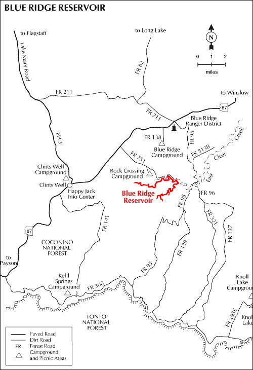
See the map below. Forest roads are graveled.
From Payson. Drive North on State Route 87 about 9 miles past Clints Well and turn right on Forest Road 751 about a mile to the campground followed by the lake (reservoir).
From Flagstaff. Drive 55 miles Southeast on Lake Mary Road to Clints Well. Then turn left (northeast) to Forest Road 138. Turn right on 138 and drive about a mile to the campground and a few miles further to the lake.
From Phoenix. Take Loop 202 East to Country Club Exit. Turn left (north) on Country Club which will turn into Highway 87 (Beeline Highway). Continue north into Payson AZ. Then follow the above directions from Payson.
Location Map To Blue Ridge Reservoir
Fishing at Blue Ridge Reservoir
Nearby Rim Lakes To Explore
- Woods Canyon Lake: A popular Rim Lake with easy access and strong trout fishing.
- Willow Springs Lake: Known for boating, kayaking, and fishing.
- Knoll Lake: A quieter forest lake ideal for camping and fishing.
- Chevelon Canyon Lake: A remote hike-in lake known for trophy trout.
Blue Ridge Reservoir FAQ
Where is Blue Ridge Reservoir Arizona?
Blue Ridge Reservoir is located along the Mogollon Rim between Payson and Flagstaff in the Coconino National Forest.
Is Blue Ridge Reservoir good for fishing?
Yes, the reservoir is known for trout fishing, including rainbow, brown, and brook trout.
Can you kayak on Blue Ridge Reservoir?
Yes, it is one of the best kayaking lakes in Arizona due to its calm water and scenic canyon layout.
Are motor boats allowed on Blue Ridge Reservoir?
Yes, but motors are limited to 10 horsepower.
Is there camping at Blue Ridge Reservoir?
Yes, Rock Crossing Campground offers developed campsites near the reservoir.
What kind of fish are in Blue Ridge Reservoir?
The reservoir contains rainbow trout, brown trout, and brook trout.
Is Blue Ridge Reservoir crowded?
No, limited access helps maintain a quieter and more peaceful environment.
When is the best time to visit Blue Ridge Reservoir?
The best time to visit is spring through fall for fishing, kayaking, and camping.
What is the elevation of Blue Ridge Reservoir?
Blue Ridge Reservoir sits at approximately 6,700 feet in elevation.
More Information and Interest
Schedules, season, restrictions, and fees are always subject to change without notice. Always verify with the Ranger District at the following phone number before visiting the reservoir or campground.
Coconino National Forest
Mogollon Rim Ranger District
(928) 477-2255
Payson Arizona Lakes
Flagstaff Arizona Lakes and Campgrounds
Other Arizona Lakes
Phoenix Area Lakes
Apache Lake
Bartlett Lake
Canyon Lake
Lake Pleasant
Roosevelt Lake
Saguaro Lake
Tempe Town Lake
Urban Lakes
Payson Area Lakes
Bear Canyon Lake
Black Canyon Lake
Blue Ridge Reservoir
Chevelon Canyon Lake
Knoll Lake
Willow Springs Lake
Woods Canyon Lake
White Mountains Lakes
Becker Lake
Big Lake
Crescent Lake
Fool Hollow Lake
Hawley Lake
Luna Lake
Lyman Lake
Rainbow Lake
Show Low Lake
Woodland Lake


