

South Mountain Park & Preserve In Phoenix
Updated by AZ Leisure Staff Writers on
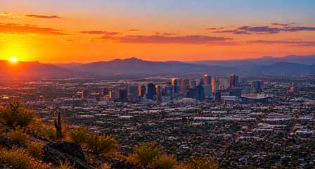
South Mountain Park and Preserve in Phoenix is one of the city's signature outdoor destinations, protecting more than 16,000 acres of Sonoran Desert and offering more than 100 miles of trails for hiking, mountain biking and horseback riding. Visitors come for panoramic Valley of the Sun views, scenic drives, desert wildlife, ancient rock art and Dobbins Lookout, the highest point in the park accessible to the public. Whether you plan to hike, bike, drive to a viewpoint or simply enjoy the desert scenery, South Mountain offers one of the best outdoor experiences within the Phoenix metropolitan area.
- About South Mountain Park
- Petroglyphs & History
- Dobbins Lookout & Scenic Drives
- Hiking Trails
- Biking, Horseback Riding & Picnicking
- Best Time To Visit
- Visitor & Heat Safety Tips
- Trail Map
- FAQ
About South Mountain Park & Preserve
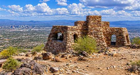
South Mountain Park and Preserve encompasses more than 16,000 acres of Sonoran Desert and is one of the largest municipally managed parks in the United States. More than 100 miles of trails cross the preserve's Ma Ha Tauk, Gila and Guadalupe mountain ranges, providing opportunities for hiking, horseback riding and mountain biking. Despite its location within metropolitan Phoenix, the park offers rugged desert scenery, native plants and wildlife, mountain ridges and expansive views across the Valley of the Sun.
Petroglyphs & Ancient History At South Mountain
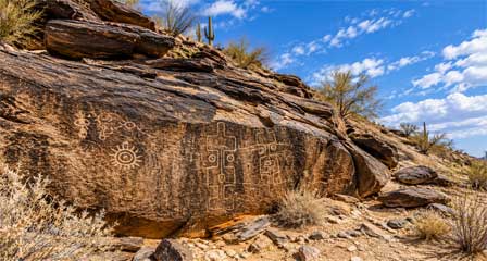
South Mountain Park and Preserve contains numerous examples of ancient rock art associated with Indigenous peoples who lived in and traveled through the region long before modern Phoenix developed. Petroglyphs can be seen along portions of the park's trail system and provide an important connection to the area's cultural history. Visitors should view rock art without touching, climbing on or altering the surfaces so these irreplaceable cultural resources can be preserved for future generations.
The Mystery Castle
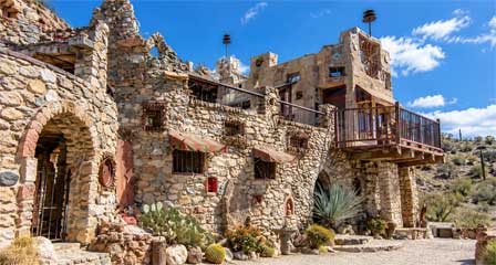
Located near the foothills of South Mountain is the unusual Mystery Castle, a longtime Phoenix landmark built beginning in the 1930s by Boyce Luther Gulley for his daughter. The sprawling structure was created from an eclectic collection of stone and other salvaged materials and remains one of the area's most unusual historic attractions. Visitors interested in seeing the property should verify current access and tour information before arriving.
Picnicking, Biking & Horseback Riding
South Mountain Park and Preserve offers much more than hiking. Its extensive trail system is popular with mountain bikers and equestrians, while the park's scenic roadways also attract road cyclists. Picnic areas and ramadas provide places to relax, enjoy the desert scenery or gather with family and friends. Some ramadas require reservations, so groups should verify current City of Phoenix requirements before visiting.
Mountain Biking At South Mountain
Mountain bikers can explore a variety of designated trails, ranging from relatively gentle desert routes to challenging rocky climbs and technical descents. The Desert Classic Trail is a popular option for riders, while other routes provide access to rugged mountain terrain. Cyclists should observe posted trail restrictions, control their speed and yield appropriately to hikers and horseback riders.
Horseback Riding At South Mountain
Horseback riding is permitted on many designated trails within South Mountain Park and Preserve. Equestrians can experience the Sonoran Desert landscape along routes that cross valleys, foothills and mountain terrain. Visitors interested in guided rides or horse rentals should verify current operators, availability and trail requirements before planning a ride.
Picnic Areas & Ramadas
Several areas of South Mountain Park offer picnic facilities and ramadas, making the preserve a popular destination for family outings and group gatherings. Some ramadas are available on a first-come basis, while others require advance reservations. Visitors should check current facility information and reservation policies before arriving.
Dobbins Lookout & Scenic Drives
Dobbins Lookout is one of the signature destinations at South Mountain Park. At approximately 2,330 feet in elevation, it is the highest point in the park accessible to the public and provides sweeping views across Phoenix and the Valley of the Sun. Visitors can reach the lookout by hiking or, when roadway access is available, by following Summit Road from the main park entrance on South Central Avenue.
South Mountain's scenic roads also provide access to overlooks, trailheads and picnic areas throughout the preserve. Summit Road is especially popular for sightseeing, photography and cycling. Drivers should use caution because the mountain road includes narrow sections, curves and areas shared with bicyclists and pedestrians.
Silent Sunday & Road Closures
South Mountain Park participates in Silent Sunday, a program that temporarily closes portions of Summit Road to regular motor vehicle traffic so visitors can enjoy walking, cycling and other non-motorized activities. Closures vary by Sunday, with more extensive restrictions generally scheduled on the fourth Sunday of each month. Visitors planning to drive to Dobbins Lookout should check current City of Phoenix roadway schedules before arriving.
San Juan Road & Scenic Overlooks
San Juan Road provides access to scenic desert terrain in the western portion of South Mountain Park. Vehicle access is limited to designated dates and hours, although visitors may explore permitted routes on foot or bicycle when conditions allow. The area offers views of rugged mountain slopes, desert valleys and the surrounding Phoenix metropolitan area. Check current park maps and road-access information before planning a drive.
Best Hiking Trails At South Mountain Park
South Mountain Park offers trails for a wide range of hiking abilities, from relatively short desert walks to demanding mountain climbs. Popular routes include Mormon Trail, Holbert Trail, Telegraph Pass and the National Trail. Trail distances and difficulty levels vary, and some routes connect with longer trail systems. Review the official City of Phoenix trail map before choosing a hike, and allow extra time for rocky terrain, elevation changes and changing weather conditions.
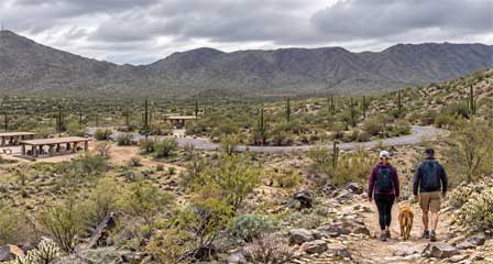
Mormon Trail
- 1.35 Miles
- Moderate to difficult
- 1,000 feet
- 24th Street and Valley View Avenue (South of Baseline Road)
Beverly Canyon Trail
- 1.5 Miles
- Easy to moderate
- 8800 South 48th Street (South of Baseline Road)
Javelina Canyon Trail
- 1.7 Miles
- Easy to moderate
- South 46th Street (South of Baseline Road)
Pima Canyon National Trail
- 14.3 Miles
- Moderate to difficult. Horses not recommended
- 9904 South 48th Street & Guadalupe Road
Desert Classic Trail
- 9 Miles
- Moderate to difficult
- 9904 South 48th Street & Guadalupe Road
Telegraph Pass Trail
- 1.5 Miles
- Easy to moderate
- North of Desert Foothills Parkway & 6th Street
Holbert Trail
- 2.5 Miles
- Difficult. Steep and long
- Left of the Main Entrance at Central Avenue
Kiwanis Trail
- 1.0 Mile
- Moderate. Steep towards the end
- Left of Main Entrance on Central Avenue
Ranger Trail
- 1.4 Miles. One way.
- Moderate. Steep switchbacks toward top end
- Left at 1 mile marker through Main Central Avenue entrance
Bajada Trail
- 3.5 Miles
- Easy to moderate
- Closes at sunset
- Drive about 2 miles from Main Central Avenue entrance. Turn right toward San Juan Valley. Turn left into gravel parking lot at the 2.5 marker.
Alta Trail
- 4.5 Miles
- Very difficult, Very steep. Not recommended for horses or bikes.
- Same parking lot as Bajada Trail
Judith Tunell Accessible Trail
Visitors seeking a shorter, more accessible desert experience can explore the Judith Tunell Accessible Trail near the South Mountain Environmental Education Center. The trail features two half-mile loops with stabilized granite surfaces, interpretive information, benches and shade ramadas. The Interpretive Loop has gentler grades, while the Challenge Loop includes somewhat steeper sections. Visitors should review current accessibility information and trail conditions before arriving.
Best Time To Visit South Mountain Park
Fall, winter and spring generally provide the most comfortable weather for hiking, biking and sightseeing at South Mountain Park. Winter days can be especially pleasant, while spring may bring seasonal desert blooms. Summer temperatures in Phoenix can become dangerously hot, so warm-season visitors should favor early morning outings, carry ample water and check current heat-related trail restrictions before heading into the preserve.
South Mountain Park Visitor & Heat Safety Tips
- Start Early: Morning visits generally provide cooler conditions and more time to explore before afternoon heat.
- Carry Plenty Of Water: Desert temperatures and low humidity can cause dehydration faster than many visitors expect.
- Check Heat Restrictions: During National Weather Service Extreme Heat Warnings, the City of Phoenix restricts access to certain trails, including Holbert Trail, Mormon Trail, Hau'pal Loop Trail and the National Trail entrance from Pima Canyon, during designated daytime hours. Verify current restrictions before hiking.
- Wear Sun Protection: Use sunscreen, protective clothing, a hat and sturdy footwear suitable for rocky desert trails.
- Stay On Designated Trails: Remaining on established routes protects fragile desert vegetation and cultural resources.
- Watch For Wildlife: South Mountain is natural desert habitat. Observe wildlife from a safe distance and never feed animals.
- Check Current Conditions: Trail access, road closures, park programs and operating hours can change, so verify current information before visiting.
Visiting Dobbins Lookout
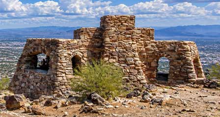
Dobbins Lookout is a popular destination for panoramic views over Phoenix and the surrounding Valley of the Sun. Visitors can reach the lookout by hiking the Holbert Trail and its Dobbins extension or by using Summit Road when vehicle access is available. Because parking and roadway conditions can vary during busy periods and special park programs, allow extra time and check current access before your visit.
South Mountain Park Hiking Trail Map
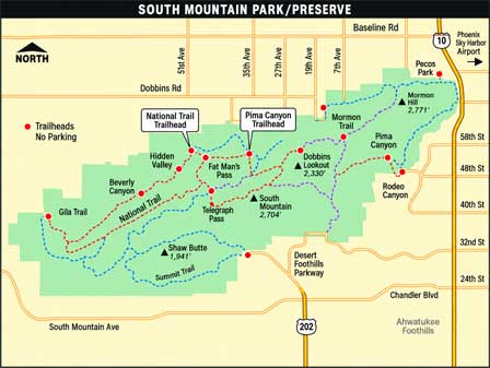
This South Mountain Park trail map provides a general overview of hiking routes, trailheads and surrounding roads. Because trails, access points and restrictions can change, visitors should also consult the official City of Phoenix South Mountain trails guide before planning a hike.
South Mountain Park Visitor Information
Main Park Entrance: 10409 South Central Avenue, Phoenix, Arizona.
Parking & Entrance Hours: Generally 5:00 a.m. to 7:00 p.m. Trail hours and individual facility schedules may differ.
Park Information: Visit the official City of Phoenix South Mountain Park & Preserve website for current operating hours, trail information, roadway restrictions and picnic ramada reservations.
South Mountain Park Phoenix FAQ
What is South Mountain Park known for?
South Mountain Park and Preserve is known for its extensive desert trail system, panoramic Phoenix views, Dobbins Lookout, scenic roadways, Sonoran Desert scenery, mountain biking, horseback riding and ancient rock art.
How large is South Mountain Park?
South Mountain Park and Preserve covers more than 16,000 acres and contains more than 100 miles of trails for hiking, mountain biking and horseback riding.
Can you drive to Dobbins Lookout?
Dobbins Lookout can normally be reached from Summit Road when the roadway is open to motor vehicles. Vehicle access may be restricted during special events or programs, so visitors should check current park conditions before driving to the lookout.
Can you hike to Dobbins Lookout?
Yes. Holbert Trail provides a popular hiking route toward Dobbins Lookout. The hike involves substantial elevation gain, so visitors should carry adequate water and prepare for desert conditions.
Are there easy trails at South Mountain Park?
Yes. South Mountain offers trails ranging from relatively easy desert walks to difficult mountain routes. Visitors should choose a trail appropriate for their experience, fitness level and current weather conditions.
Is mountain biking allowed at South Mountain Park?
Yes. Mountain biking is permitted on many trails at South Mountain Park and Preserve, and the park's roadways are also popular with cyclists.
What is the best time to visit South Mountain Park?
Fall through spring generally offers the most comfortable conditions for hiking and other outdoor activities. During warmer months, early morning visits are preferable, and visitors should check for extreme-heat trail restrictions before hiking.
Does South Mountain Park have picnic areas?
Yes. South Mountain Park has picnic areas and ramadas at several locations. Some facilities may require reservations, particularly for groups, so current requirements should be checked before visiting.
Other Greater Phoenix AZ Area Hiking Trails
Camelback Mountain
Papago Park
Piestewa Peak
South Mountain Park
Related Phoenix Interest
Phoenix Arizona
Greater Phoenix Map
Rawhide Western Town
Roosevelt Lake Map & Directions
Phoenix To South Rim
Greater Phoenix Things To Do
Hiking Papago Park
Phoenix Dude Ranches
Phoenix Events & Festivals
Desert Botanical Garden
Piestewa Peak Hiking
Phoenix Weather Info
Phoenix Boat Tours
Mystery Castle
Phoenix Horseback Riding
Camelback Mountain
Phoenix Area Museums
Phoenix Zoo
Phoenix Arts & Theatre
Japanese Friendship Garden
Phoenix Fishing Guides
Phoenix Area Attractions
Metro Phoenix