

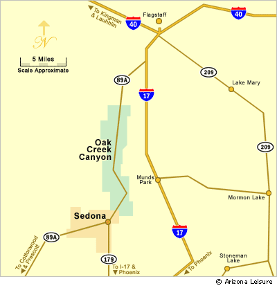
Sedona Area Map
Last updated on .
Oak Creek Canyon, Verde Valley & Nearby Attractions
The Sedona and Oak Creek Canyon area map provides a clear overview of one of Arizona’s most popular travel destinations, highlighting key landmarks, scenic routes, and nearby attractions. Located between Phoenix and Flagstaff, Sedona is easily accessible and serves as a central hub for exploring northern Arizona. This map helps visitors visualize distances, plan routes, and identify must-see locations throughout the region.
How To Use This Sedona Area Map
Use this Sedona area map to understand where Sedona sits in relation to Oak Creek Canyon, the Verde Valley, Flagstaff, Jerome, Camp Verde, Phoenix, Prescott, and the Grand Canyon. The map is helpful for planning scenic drives, day trips, nearby attractions, and multi-stop Arizona travel routes.
Popular Locations Near Sedona & Oak Creek Canyon
Sedona’s central location makes it easy to explore a wide variety of nearby attractions within a short drive. Visitors can head north through Oak Creek Canyon to Flagstaff, explore ancient cliff dwellings at Montezuma Castle National Monument, or take a scenic drive west to historic Jerome. Day trips to the Grand Canyon National Park are also popular, making Sedona an ideal base for multi-destination Arizona adventures.
Sedona and Verde Valley Area Map
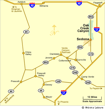
Approximate Mileage Guide
Camp Verde - 37 Miles South of Sedona
Flagstaff - 30 Miles North of Sedona
Grand Canyon - 80 Miles North of Sedona
Jerome - 29 Miles West of Sedona
Phoenix - 120 Miles South of Sedona
Prescott - 50 Miles Southwest of Sedona
Best Day Trips From Sedona
- Oak Creek Canyon: A scenic drive north of Sedona with canyon views, forest scenery, and access to hiking areas.
- Flagstaff: A mountain city about 30 miles north of Sedona with historic downtown, forests, and San Francisco Peaks access.
- Jerome: A historic hillside town west of Sedona known for views, shops, history, and old mining character.
- Camp Verde: A convenient Verde Valley base near Montezuma Castle, wildlife attractions, and river recreation.
- Grand Canyon: A popular longer day trip north of Sedona for visitors planning a full-day scenic adventure.
- Prescott: A historic Arizona city southwest of Sedona with lakes, downtown attractions, and mountain scenery.
Sedona Area Map FAQ
Where is Sedona located in Arizona?
Sedona is located in north-central Arizona between Phoenix and Flagstaff, near Oak Creek Canyon and the Verde Valley.
How far is Sedona from Flagstaff?
Sedona is about 30 miles south of Flagstaff by way of Oak Creek Canyon.
How far is Sedona from Phoenix?
Sedona is about 120 miles north of Phoenix, depending on the route and starting point.
What towns are near Sedona?
Nearby towns include Cottonwood, Jerome, Camp Verde, Cornville, Flagstaff, and Prescott.
Can you visit the Grand Canyon from Sedona?
Yes, the Grand Canyon is about 80 miles north of Sedona and is a popular full-day trip from the area.
Additional Sedona Area Information
Map & Directions Oak Creek Trail
Oak Creek Canyon Map & Directions
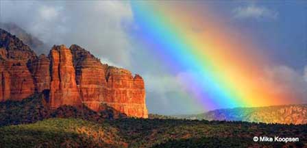
Oak Creek Canyon Photos By Koopsen
Oak Creek Canyon Vista Point
Sedona Aerial Photos By Koopsen
Sedona Winter Photos By Koopsen
Verde Canyon Railroad
The Wonder Of Sedona & Oak Creek
Sedona-Oak Creek Canyon
Sedona Arizona
Oak Creek Canyon
Arizona Route 66
Map & Directions
Weather & Climate
Sedona Pictures
Things To Do
Public Golf Courses
Grand Canyon Tours
West Fork Trail
Desert Canyon Drive
Sedona Museums
Events & Festivals
Horseback Riding
Area Attractions
Palatki Indian Ruins
Montezuma Castle
Montezuma Well
Grand Canyon South Rim
Sycamore Canyon
Slide Rock State Park
Grand Canyon Railway
Chapel of the Holy Cross
Oak Creek
Nearby Towns
Flagstaff Arizona
Jerome Arizona
Cornville Arizona
Williams Arizona
Cottonwood Arizona
Sedona Articles
Native American History
Vortex Visions
Mystical Vortexes
Enchantment Resort
Credit The Sinagua
Where To Stay
Cabins & Lodges
RV Parks & Campgrounds
Bed and Breakfast
Sedona Vacation Rentals
Sedona Timeshares


