

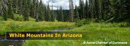
Greer Arizona Directions & Map
Updated by AZ Leisure Staff Writers on
Greer is a high-elevation mountain community in eastern Arizona's White Mountains, reached by State Route 373 from State Route 260. Travelers from Phoenix generally approach through Payson, Show Low and Pinetop-Lakeside, while routes from Tucson, Flagstaff, Albuquerque and eastern Arizona eventually connect with SR 260 for the final approach. The last several miles into Greer follow the scenic Greer Highway, SR 373, through pine forest and mountain meadows.
- Where Is Greer Arizona?
- Greer Arizona Map
- Directions From Phoenix
- Directions From Tucson
- Directions From Flagstaff
- Directions From Show Low & Pinetop-Lakeside
- SR 260 & Greer Scenic Drive
- Winter Driving & Road Conditions
- Greer Driving Tips
- Greer Directions FAQ
Where Is Greer Arizona?
Greer is located in Apache County in the White Mountains of eastern Arizona at an elevation of more than 8,000 feet. The community lies south of State Route 260 and is reached by State Route 373, the Greer Highway.
Greer's mountain location places it near Pinetop-Lakeside, Show Low, Springerville-Eagar, Sunrise Park Resort and recreation areas throughout the Apache-Sitgreaves National Forests. The final approach on SR 373 is a short paved mountain drive from SR 260 into Greer.
Greer Arizona Map
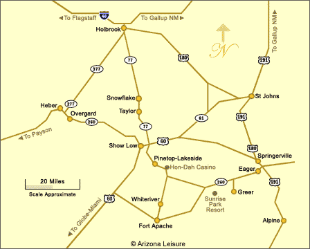
Interactive Map Of Greer Arizona
Directions To Greer From Phoenix & Scottsdale
From the Phoenix and Scottsdale area, travel northeast on State Route 87, the Beeline Highway, toward Payson. In Payson, continue east on State Route 260 toward Show Low. Follow SR 260 through Show Low and Pinetop-Lakeside and continue east through the White Mountains. Turn right, or south, onto State Route 373 at the signed Greer turnoff and follow the Greer Highway into town.
This route crosses the Mogollon Rim and includes long stretches of mountain highway, so travel time can vary with traffic, weather, road construction and seasonal conditions.
Directions To Greer From Tucson
From Tucson, a common route follows State Route 77 north toward Oracle and Globe, then connects with U.S. Highway 60 toward Show Low. In Show Low, follow State Route 260 east through Pinetop-Lakeside and the White Mountains. Turn south onto State Route 373 at the Greer turnoff and continue into Greer.
Mountain weather, construction and road conditions can affect the fastest route, so check current navigation and Arizona highway conditions before departure.
Directions To Greer From Flagstaff
From Flagstaff, travel east toward the Show Low and White Mountains area using the appropriate current highway route shown by your navigation system. From Show Low, continue east on State Route 260 through Pinetop-Lakeside. Turn south onto State Route 373 at the signed Greer turnoff and follow the highway into Greer.
Because several highway combinations can be used between Flagstaff and Show Low, check current navigation and AZ511 before departure rather than relying on a fixed route during winter weather or highway construction.
Directions From Show Low & Pinetop-Lakeside
From Show Low, follow State Route 260 east through Pinetop-Lakeside and continue through the White Mountains. Pass the Hon-Dah area and continue east on SR 260 toward the signed Greer turnoff. Turn right, or south, onto State Route 373.
SR 373 continues approximately 4.6 miles from SR 260 into Greer. The highway becomes the main road through the community.
SR 260 & The Greer Scenic Drive
The approach to Greer is part of the White Mountains driving experience. State Route 260 passes through forests, open meadows and high-country scenery, while State Route 373 provides the final short drive from SR 260 into Greer.
ADOT recognizes State Route 260 as part of the White Mountain Scenic Road and specifically describes the 4.6-mile Greer Highway as a scenic route through pine forests and open glades. Travelers should allow time for mountain scenery while remaining alert for wildlife and changing weather.
Winter Driving To Greer Arizona
Greer's high elevation means winter trips can involve snow, ice, reduced visibility and rapidly changing road conditions. State Route 260 and the final approach on SR 373 are paved, but mountain weather can make driving significantly slower than during dry conditions.
- Check current road conditions before leaving home
- Allow additional travel time during or immediately after winter storms
- Reduce speed on shaded or icy sections of mountain highway
- Watch for snowplows and temporary highway restrictions
- Keep extra fuel, warm clothing, water and basic emergency supplies in the vehicle
- Do not rely solely on estimated GPS travel times during winter weather
Tips For Driving To Greer Arizona
- Check AZ511 for current highway conditions before traveling
- Fill the fuel tank before entering the more remote stretches of the White Mountains
- Expect deer, elk and other wildlife near highways, especially around dawn and dusk
- Allow extra travel time for winter weather, summer thunderstorms and holiday traffic
- Use caution on winding and high-elevation highway sections
- Download or save your route before leaving areas with reliable cellular service
- Watch carefully for the signed SR 373 Greer turnoff from SR 260
- Expect the final SR 373 approach to Greer to take you through forest and open mountain meadows
Seasonal Travel To Greer
Greer can be reached year-round, but driving conditions vary significantly by season. Spring can bring lingering snow or late storms, summer may bring afternoon thunderstorms, fall generally offers excellent driving conditions and colorful mountain scenery, and winter travel can involve snow and ice. Always check current weather and road conditions before a high-country trip.
Nearby White Mountains Destinations
- Greer Arizona for cabins, restaurants and local recreation
- Sunrise Park Resort for skiing and mountain recreation
- Big Lake for fishing, boating and mountain scenery
- Pinetop-Lakeside for lodging, dining and shopping
- Show Low for major services and supplies
- Arizona White Mountains for lakes, forests and outdoor recreation
Greer Arizona Directions FAQ
Where is Greer Arizona?
Greer is located in the White Mountains of eastern Arizona in Apache County. The community is reached from State Route 260 by taking State Route 373 south into Greer.
What highway goes directly to Greer Arizona?
State Route 373, also known as the Greer Highway, connects State Route 260 directly with Greer.
How long is State Route 373 into Greer?
ADOT describes the Greer Highway portion of State Route 373 as approximately 4.6 miles long.
How do you get to Greer from Phoenix?
A common route from the Phoenix area follows State Route 87 northeast to Payson, then State Route 260 east through Show Low and Pinetop-Lakeside. Turn south onto State Route 373 at the Greer turnoff.
How do you get to Greer from Tucson?
A common route from Tucson travels north toward Globe, then follows U.S. Highway 60 toward Show Low. From Show Low, take State Route 260 east and turn south onto State Route 373 for Greer.
How do you get to Greer from Show Low?
From Show Low, follow State Route 260 east through Pinetop-Lakeside and continue to the signed State Route 373 Greer turnoff. Turn south and follow SR 373 into town.
Is the road to Greer Arizona paved?
Yes. State Route 373 is a paved state highway connecting Greer with State Route 260.
Can you drive to Greer in winter?
Yes, but snow and ice can affect White Mountains highways during winter storms. Check current AZ511 conditions before traveling and allow additional driving time when winter weather is expected.
Is the drive to Greer scenic?
Yes. ADOT recognizes State Route 260 as part of the White Mountain Scenic Road and describes the Greer Highway as a scenic drive through pine forests and open mountain country.
Where can I check road conditions before driving to Greer?
Arizona highway conditions, closures, restrictions and roadwork can be checked through the Arizona Department of Transportation's AZ511 traveler information system.
Related Greer Interest
Benny Creek RV Campground
Greer Weather Info
Greer RV Campgrounds
Greer RV Parks
Greer No Longer A Secret
Rolfe C. Hoyer Campground
Winn RV Campground
Beautiful White Mountains In Arizona
White Mountains
Map & Directions
Little Colorado River
Weather & Climate
Alpine Arizona
Heber/Overgaard
Pinetop-Lakeside
Payson Arizona
About Show Low
Snowflake/Taylor
Springerville Arizona
Greer Arizona
Popular Area Lakes
Rainbow Lake
White Mountains Lakes
Big Lake
Hawley Lake
Show Low Lake
Crescent Lake
Woodland Lake
Luna Lake
Becker Lake
Fool Hollow Lake
Lyman Lake















