

Yuma Arizona Map
Last updated on .
Where is Yuma Arizona Located?
Located in the far southwest corner of Arizona along the Colorado River, Yuma is a key gateway city connecting Arizona, California, and Mexico. This map of Yuma, Arizona highlights the city’s strategic location near major highways, neighboring desert communities, and popular Colorado River destinations such as Parker and Lake Havasu. Whether you’re planning a road trip, exploring Southern Arizona, or navigating the Colorado River region, this locator map provides a clear geographic overview of Yuma and surrounding areas.
Yuma Arizona Map & Location
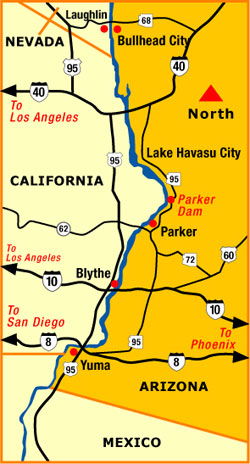 Yuma Arizona map showing Colorado River cities and regional highways
Routes to Yuma Arizona
Yuma is easily accessible by several major highways that connect it to the Southwest’s largest cities. From Phoenix, travelers typically take Interstate 10 west to U.S. Route 95 south, offering a direct route through desert landscapes and river communities. Visitors coming from San Diego or Southern California often use Interstate 8 east, which runs directly into Yuma and provides the most convenient access from the coast. From Las Vegas, routes commonly pass through Kingman and follow U.S. Route 95 south along the Colorado River corridor. Yuma’s location near the California and Mexico borders also makes it a major regional hub for cross-border travel, agriculture, and commerce.
Driving Distances to Yuma
From Phoenix, Arizona
- Distance: Approximately 185–200 miles
- Drive Time: About 3 to 3.5 hours
- Route: Interstate 10 West to U.S. Route 95 South
From San Diego, California
- Distance: Approximately 170 miles
- Drive Time: About 2.5 to 3 hours
- Route: Interstate 8 East directly into Yuma
From Tucson, Arizona
- Distance: Approximately 240 miles
- Drive Time: About 3.5 to 4 hours
- Route: Interstate 10 West to State Route 85 North, then Interstate 8 West
From Las Vegas, Nevada
- Distance: Approximately 290 miles
- Drive Time: About 4.5 to 5 hours
- Route: U.S. Route 93 South to Interstate 40, then U.S. Route 95 South
Related Yuma Interest
Yuma Arizona
Mexicali Mexico
Yuma Attractions
Yuma Dune Buggy Rentals
Southern Arizona Destinations


