


Phoenix Area Map & Greater Phoenix Valley Guide
Reviewed and updated by AZ Leisure Staff Writers on
Greater Phoenix Area Map & Valley of the Sun Overview
This Phoenix area map shows the general layout of Greater Phoenix, including Phoenix, Scottsdale, Tempe, Mesa, Chandler, Glendale and surrounding Valley communities. Use it to understand the relationship between major cities, suburbs and highway corridors when planning a vacation, day trip, relocation or drive across the metropolitan area.
Greater Phoenix stretches across a broad section of central Arizona, so distances between attractions and communities can be significant. Knowing whether a destination lies in the East Valley, West Valley, central Phoenix or farther north can make trip planning and lodging decisions much easier.
- Phoenix Map Quick Facts
- Phoenix Area Map
- Major Cities
- East Valley & West Valley
- Major Highways
- Getting Around Greater Phoenix
- Lakes & Outdoor Recreation
- City Maps
- Map & Travel Tips
- FAQ
Map Of Greater Phoenix Cities & Highways
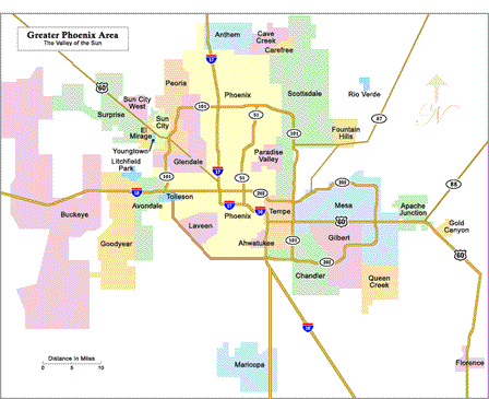
Map of Phoenix Area Cities and Highways
Greater Phoenix is a large, interconnected metropolitan region extending across much of Maricopa County and into portions of Pinal County. Phoenix forms the geographic and economic center, while surrounding cities such as Scottsdale, Tempe, Mesa, Chandler, Gilbert, Glendale and Peoria function as distinct destinations and communities within the larger Valley.
The region continues to expand outward, which makes geographic orientation particularly useful for visitors and new residents. Attractions that appear close together on a statewide Arizona map may require substantial driving time once local streets, freeways and traffic are considered.
What This Phoenix Area Map Shows
- Major cities and suburbs throughout Greater Phoenix
- Central Phoenix and surrounding Valley communities
- East Valley and West Valley locations
- Major interstate and loop freeway corridors
- Routes toward Tucson, Flagstaff and California
- Connections toward Scottsdale, Mesa, Chandler and Glendale
- General orientation for attractions, lodging and outdoor recreation
Use the map as a regional orientation tool, then consult individual city maps, current navigation services and traffic information for detailed turn-by-turn travel.
Major Cities In The Phoenix Metropolitan Area
Greater Phoenix includes numerous incorporated cities and towns, each with its own attractions, neighborhoods, employment centers and recreation areas.
Central & Major Valley Cities
- Phoenix – Arizona's capital and the Valley's largest city
- Mesa – Major East Valley city with cultural and outdoor attractions
- Chandler – Southeast Valley city with business, dining and residential districts
- Scottsdale – Known for resorts, golf, shopping, dining and nightlife
- Glendale – West Valley destination for sports, entertainment and shopping
- Tempe – Home to Arizona State University, Mill Avenue and Tempe Town Lake
Other Greater Phoenix Communities
- Gilbert – Southeast Valley community near Chandler and Mesa
- Peoria – Northwest Valley city extending toward Lake Pleasant
- Surprise – West Valley community northwest of Glendale
- Goodyear – West Valley city along the I-10 corridor
- Queen Creek – Southeast Valley community near the San Tan Mountains
East Valley, West Valley & Central Phoenix
Central Phoenix generally includes downtown, Midtown, Uptown and surrounding Phoenix neighborhoods. This area provides convenient access to museums, professional sports, restaurants, arts venues and several central-city attractions.
The East Valley commonly refers to communities east and southeast of Phoenix, including Tempe, Mesa, Chandler, Gilbert and nearby areas. Scottsdale lies northeast of central Phoenix and is often grouped with the eastern side of Greater Phoenix for visitor planning.
The West Valley includes Glendale, Peoria, Surprise, Goodyear, Avondale and other communities west and northwest of central Phoenix. Major sports venues, entertainment districts and access toward Lake Pleasant are located on this side of the Valley.
Major Phoenix Highways & Freeways
Understanding the freeway system is essential when navigating Greater Phoenix because destinations may be many miles apart.
- I-10: Major east-west interstate connecting Phoenix with California and Tucson
- I-17: Main north-south route from Phoenix toward Flagstaff and northern Arizona
- Loop 101: Connects portions of Scottsdale, Tempe, Glendale, Peoria and the northern Valley
- Loop 202: Major freeway system serving Phoenix, Tempe, Mesa, Chandler and the southeast Valley
- Loop 303: Important northwest and West Valley corridor
- U.S. 60: Major East Valley route through Tempe, Mesa and toward Apache Junction
Getting Around Greater Phoenix
Greater Phoenix is geographically spread out, and driving remains the most practical way to reach many attractions, suburban communities, trailheads and lakes. Freeways provide relatively direct connections between major areas, but travel times can increase considerably during weekday commute periods, major sporting events and construction.
When choosing a hotel or vacation rental, consider where most of your planned activities are located. Staying near the attractions you intend to visit can substantially reduce daily driving.
Lakes & Outdoor Recreation Near Phoenix
Greater Phoenix is surrounded by Sonoran Desert mountains, regional parks and reservoirs that provide hiking, boating, fishing, paddling, camping and wildlife-viewing opportunities.
Popular Lakes Near Phoenix
- Lake Pleasant – Popular northwest Valley destination for boating, fishing and camping
- Saguaro Lake – Scenic reservoir surrounded by Sonoran Desert and canyon terrain
- Canyon Lake – Known for steep desert cliffs, boating and fishing
- Apache Lake – Remote reservoir east of the Valley in rugged desert country
- Bartlett Lake – Popular northeast-area destination for boating and fishing
Travel time varies considerably depending on the lake, starting point, traffic and road conditions. Use individual lake pages for current directions and access information.
Outdoor Activities Around Greater Phoenix
- Hiking at Camelback Mountain, South Mountain and regional desert preserves
- Mountain biking and trail riding
- Fishing, boating and paddling at nearby lakes
- Desert scenic drives and designated off-highway recreation
- Golf throughout Phoenix, Scottsdale and surrounding communities
- Camping and wildlife viewing in nearby desert and mountain areas
The combination of city attractions and nearby Sonoran Desert recreation makes Greater Phoenix especially useful as a base for travelers who want both urban and outdoor activities.
Using The Phoenix Map For Relocation Research
For people considering a move to Greater Phoenix, the regional map is useful for comparing communities with employment centers, freeway access, airports, universities, shopping districts and outdoor recreation. Because the Valley covers such a large area, location can have a major effect on commute distance and access to everyday services.
Use this regional map for initial orientation, then compare individual city maps, commute routes, housing information and current local data before choosing a neighborhood or community.
Greater Phoenix City Maps
- Apache Junction Area Map
- Chandler Area Map
- Mesa Area Map
- Scottsdale Area Map
- Tempe Area Map
- Wickenburg Area Map
Interactive Phoenix Area Map
Phoenix Area Map & Travel Tips
- Check drive times as well as mileage when planning trips across Greater Phoenix.
- Allow additional travel time during weekday commute periods.
- Choose lodging near the attractions or communities you expect to visit most often.
- Use I-10 and I-17 for major regional connections beyond the Valley.
- Use Loop 101 and Loop 202 for many cross-Valley trips.
- Check current construction and traffic conditions before longer drives.
- Do not assume that every Greater Phoenix attraction is close to downtown Phoenix.
- Check individual lake pages before driving to remote recreation areas.
- Carry water when traveling into desert recreation areas.
- Use detailed navigation in addition to this regional orientation map.
Phoenix Area Map FAQ
What Is The Valley Of The Sun?
The Valley of the Sun is a common nickname for the Greater Phoenix metropolitan area in central Arizona.
What Cities Are In The Phoenix Metropolitan Area?
Major Greater Phoenix cities include Phoenix, Scottsdale, Tempe, Mesa, Chandler, Gilbert, Glendale, Peoria, Surprise, Goodyear and other surrounding communities.
What Is Considered The East Valley?
The East Valley commonly includes Tempe, Mesa, Chandler, Gilbert and nearby communities east and southeast of central Phoenix.
What Is Considered The West Valley?
The West Valley commonly includes Glendale, Peoria, Surprise, Goodyear, Avondale and other communities west and northwest of central Phoenix.
What Are The Main Freeways In Phoenix?
Major routes include I-10, I-17, Loop 101, Loop 202, Loop 303 and U.S. 60.
Is Greater Phoenix Easy To Drive Around?
Major freeways connect most communities, but Greater Phoenix covers a large area and travel times can increase substantially during commute periods and major events.
What Lakes Are Near Phoenix?
Popular lakes include Lake Pleasant, Saguaro Lake, Canyon Lake, Apache Lake and Bartlett Lake.
Which Phoenix Areas Are Closest To Scottsdale?
Scottsdale lies east and northeast of central Phoenix, with convenient connections from Phoenix, Tempe and other eastern Valley communities.
Is Phoenix Sky Harbor Airport Near Downtown?
Phoenix Sky Harbor International Airport is located just southeast of downtown Phoenix and provides convenient access to central Phoenix, Tempe and nearby freeway routes.
Should I Use This Map For Turn-By-Turn Directions?
No. This map is designed for regional orientation. Use current navigation and traffic information for turn-by-turn driving directions.
More Greater Phoenix Maps & Travel Information
- Phoenix Arizona Vacation Guide
- Things To Do In Greater Phoenix
- Phoenix Area Attractions
- Phoenix Weather & Climate
- Scottsdale Area Map
- Mesa Area Map
- Chandler Area Map
- Tempe Area Map
- Phoenix Area Lakes
- South Mountain Park & Preserve
- Camelback Mountain
- Phoenix To The Grand Canyon South Rim
Metro Phoenix















