

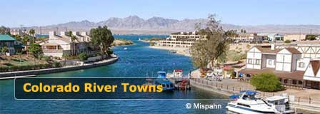
Parker Arizona Map & Driving Directions
Updated by AZ Leisure Staff Writers on
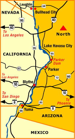
Parker is located in western Arizona along the lower Colorado River corridor near the California border. State Route 95 is the primary north-south highway through the area, connecting Parker with Lake Havasu City to the north and Interstate 10 at Quartzsite to the south.
The maps and driving information below show Parker's relationship to the Parker Strip, Parker Dam, Lake Havasu, Quartzsite, Blythe and other Colorado River communities. Parker's location makes it a convenient base for boating, fishing, camping, off-highway recreation and road trips throughout western Arizona and southeastern California.
- Parker Map Quick Facts
- Colorado River Area Map
- Directions From Phoenix
- Directions From Lake Havasu City
- Directions From Quartzsite & I-10
- Directions From Blythe California
- Parker Strip & Parker Dam
- Driving Distances
- Driving Tips
- FAQ
Parker Arizona Map Quick Facts
- Primary highway: Arizona State Route 95
- Interstate access: Interstate 10 at Quartzsite
- Colorado River: Immediately west of the Parker area
- Parker Strip: Approximately 18 miles along the Colorado River
- Lake Havasu City: Approximately 53 road miles north
- Quartzsite: Approximately 35 road miles south
- Blythe, California: Approximately 49 to 51 road miles
- Phoenix: Approximately 156 road miles
- Nearby recreation: Boating, fishing, camping, hiking and off-highway travel
- Important restriction: Oversized vehicles and vehicles towing trailers cannot cross Parker Dam
Parker Arizona & Colorado River Area Map
The map shows Parker's location within the western Arizona Colorado River corridor, including nearby communities and regional routes. Use current navigation in addition to this regional map when planning individual road trips.
Directions To Parker Arizona From Phoenix
From Phoenix, take Interstate 10 west toward Quartzsite. At Quartzsite, exit onto Arizona State Route 95 and travel north to Parker. The drive is approximately 156 miles and normally takes about 2½ to 3 hours, depending on traffic and stops.
This is the most straightforward highway route from the Phoenix metropolitan area and keeps most of the trip on Interstate 10 before the final northbound segment on SR 95.
Directions To Parker From Lake Havasu City
From Lake Havasu City, follow Arizona State Route 95 south toward Parker. The route passes through western Arizona desert scenery and approaches the Colorado River recreation areas north of Parker.
The drive is approximately 53 miles. Travelers heading specifically to Parker Strip resorts, campgrounds or river-access areas should use current navigation because many destinations are located north of the town itself along SR 95.
Directions To Parker From Quartzsite & Interstate 10
From Interstate 10 at Quartzsite, take Arizona State Route 95 north toward Parker. Continue north on SR 95 for approximately 35 miles to reach the Parker area.
Quartzsite is the primary Interstate 10 connection for travelers approaching Parker from Phoenix, western Arizona and southeastern California.
Directions To Parker From Blythe California
From Blythe, travel east on Interstate 10 into Arizona toward Quartzsite, then take State Route 95 north to Parker. The total drive is approximately 50 miles.
This route provides convenient Parker access for travelers arriving from southeastern California and the Interstate 10 corridor.
Parker Strip & Parker Dam
The Parker Strip follows approximately 18 miles of the Colorado River between Parker Dam and Headgate Dam. Resorts, RV parks, campgrounds, boat ramps and river recreation areas are located along this corridor north of Parker.
Arizona State Route 95 follows the Arizona side of the river, while Parker Dam Road provides a scenic route on the California side. Parker Dam Road can be accessed by crossing the river north of Parker, but oversized vehicles and vehicles towing trailers are prohibited from crossing Parker Dam itself.
Visitors traveling with large RVs, trailers or boats should remain on appropriate state highways and use current navigation rather than planning to cross the dam.
Approximate Driving Distances From Parker
- Quartzsite: About 35 miles
- Blythe, California: About 50 miles
- Lake Havasu City: About 53 miles
- Phoenix: About 156 miles
- Interstate 10: About 35 miles south at Quartzsite
- Parker Dam: North of Parker along the Parker Strip
Driving distances are approximate and can vary depending on the exact starting point, destination and selected route.
What Is Near Parker Arizona?
North of Parker, State Route 95 follows the Colorado River corridor toward Parker Dam and Lake Havasu City. Buckskin Mountain State Park and River Island State Park provide riverfront camping, boating, swimming, hiking and fishing along the Parker Strip.
South of Parker, SR 95 leads to Quartzsite and Interstate 10. West of the Colorado River are southeastern California communities and the Parker Dam Road scenic corridor.
Parker Arizona Driving Tips
- Check current road conditions before long-distance travel through western Arizona.
- Carry drinking water during all seasons, especially in summer.
- Keep adequate fuel when traveling through remote desert areas.
- Use State Route 95 for primary north-south travel through Parker.
- Use Interstate 10 at Quartzsite for the main Phoenix and California highway connection.
- Expect recreational traffic along the Parker Strip on weekends and holidays.
- Use caution when towing boats or travel trailers on two-lane river roads.
- Do not attempt to cross Parker Dam with an oversized vehicle or trailer.
- Watch for wildlife when driving near the river after dark.
- Use current navigation in addition to the regional map shown on this page.
Parker Arizona Map & Directions FAQ
Where Is Parker Arizona?
Parker is located in western Arizona near the Colorado River and California border in La Paz County.
What Highway Goes Through Parker Arizona?
Arizona State Route 95 is the primary north-south highway serving Parker. It connects Parker with Lake Havasu City to the north and Quartzsite and Interstate 10 to the south.
How Far Is Parker Arizona From Phoenix?
Parker is approximately 156 road miles from Phoenix, with the primary route using Interstate 10 west to Quartzsite and State Route 95 north.
How Far Is Parker From Lake Havasu City?
Parker and Lake Havasu City are approximately 53 road miles apart by way of State Route 95.
How Far Is Parker From Quartzsite?
Parker is approximately 35 miles north of Quartzsite on Arizona State Route 95.
How Far Is Parker From Blythe California?
Parker is approximately 50 road miles from Blythe, California, generally traveling through Quartzsite and Interstate 10.
What Is The Parker Strip?
The Parker Strip is an approximately 18-mile stretch of the Colorado River between Parker Dam and Headgate Dam with resorts, campgrounds, boat ramps and recreation areas.
Can RVs And Trailers Cross Parker Dam?
No. Oversized vehicles and vehicles towing trailers are prohibited from crossing Parker Dam.
What Is The Best Route From Phoenix To Parker?
The most straightforward route is Interstate 10 west from Phoenix to Quartzsite, then Arizona State Route 95 north to Parker.
Is Parker A Good Base For Colorado River Recreation?
Yes. Parker provides convenient access to the Parker Strip, Colorado River boating and fishing, Buckskin Mountain State Park, River Island State Park and the Lake Havasu region.
More Parker & Colorado River Information
- Parker Arizona Visitor Guide
- Arizona Colorado River Towns
- Lake Havasu City Arizona
- Lake Havasu
- Bullhead City Arizona
- Laughlin Nevada
- Yuma Arizona
- Boating In Arizona
Along The Colorado River
Colorado River Lakes
Lake Powell
Lake Mead
Lake Mohave
Lake Havasu















