

Horseshoe Bend Near Page Arizona
Updated by AZ Leisure Staff Writers on
 Horseshoe Bend. Credit: NPS
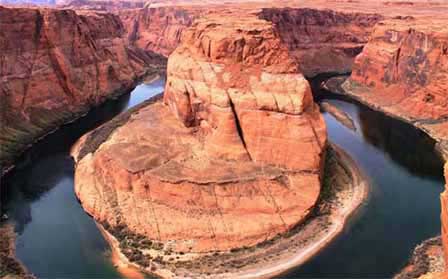
Horseshoe Bend is one of northern Arizona's most recognizable viewpoints, where the Colorado River makes a dramatic 270-degree curve around a massive sandstone escarpment just south of Page. From the overlook, visitors look approximately 1,000 feet down into Glen Canyon and across a sweeping landscape of red sandstone cliffs and the Colorado River. A developed 1.5-mile round-trip trail leads from the parking area to an accessible viewing platform, making Horseshoe Bend an easy addition to a visit to Page, Lake Powell, Glen Canyon Dam or Antelope Canyon.
- Horseshoe Bend Overview
- Horseshoe Bend Hike
- Accessibility & Viewing Platform
- Parking & Hours
- Safety & Summer Heat
- Best Time For Photos
- How Horseshoe Bend Formed
- Horseshoe Bend Map
- Directions From Page & Flagstaff
- Things To Do Nearby
- Horseshoe Bend FAQ
Horseshoe Bend On The Colorado River
Horseshoe Bend lies just south of Page within the greater Glen Canyon landscape. The Colorado River curves around a sandstone formation in a broad horseshoe-shaped meander before continuing downstream toward Lees Ferry and eventually Grand Canyon National Park.
The overlook itself is part of Glen Canyon National Recreation Area. The parking area is operated by the City of Page, while nearby land also borders the Navajo Nation, making Horseshoe Bend an unusual location where several jurisdictions meet.
The Hike To Horseshoe Bend
The Horseshoe Bend Trail is approximately 1.5 miles round trip from the parking area to the overlook and back. The hardened trail crosses an open desert plateau with relatively little shade, although two shade structures are located along the route.
The hike is generally considered easy, but summer heat can make the short distance much more demanding. Carry drinking water, wear sturdy footwear and sun protection, and avoid the hottest part of the day during periods of extreme heat.
Horseshoe Bend Video
Horseshoe Bend Accessibility & Viewing Platform
The developed trail from the parking area to Horseshoe Bend is designed for low-mobility access and is suitable for many wheelchairs and strollers. The trail surface is a hardened sand-based material intended to blend with the surrounding desert landscape.
A flat viewing platform at the overlook has protective railings along its edge. However, the railing does not extend around the entire canyon rim. Large sections beyond the viewing platform remain natural, rocky and completely unprotected above an approximately 1,000-foot drop.
Horseshoe Bend Parking & Hours
The Horseshoe Bend parking lot and trailhead are located off US Highway 89 approximately five miles south of Page. The parking area is operated by the City of Page and requires a parking fee.
National Park Service and America the Beautiful passes do not cover the City of Page parking fee. During especially busy holidays and weekends, parking procedures may change and shuttle service may be required when the lot reaches capacity.
The Horseshoe Bend trail, parking area and overlook are open during daylight hours from sunrise to sunset. Overnight camping is not permitted at the overlook.
Horseshoe Bend Safety & Desert Heat
Horseshoe Bend's dramatic setting requires caution. The developed viewing platform has a railing, but much of the surrounding rim remains unprotected. Keep children and pets close and stay well back from unprotected cliff edges.
- Carry plenty of drinking water for every member of your group
- Avoid hiking during the hottest part of summer days
- Wear sturdy shoes, sunscreen, a hat and other sun protection
- Keep pets on a leash no longer than six feet
- Protect pets' paws from extremely hot trail surfaces
- Never leave pets unattended in a parked vehicle
- Use the restroom in the parking area before hiking because there are no toilets along the trail
- Stay away from exposed canyon edges outside the protected viewing platform
Best Time To Photograph Horseshoe Bend
Horseshoe Bend can look dramatically different as the sun moves across Glen Canyon. Morning generally provides cooler temperatures and softer conditions for the hike, while late afternoon and sunset can produce warmer light on the sandstone walls. Midday places more light into the canyon but can also bring intense heat and harsh contrast during summer.
Photographers should arrive with enough time to walk the 1.5-mile round-trip trail before sunset. The parking lot and overlook close after daylight hours, so do not plan to remain at the site after dark unless participating in an officially scheduled program.
Horseshoe Bend Location Map

How Horseshoe Bend Was Formed
Horseshoe Bend is an entrenched river meander. Long before the canyon reached its present depth, the Colorado River wandered across a much flatter landscape and developed broad bends as it followed the path of least resistance.
As the Colorado Plateau gradually uplifted, the river maintained its established course while cutting downward through layers of sandstone. Over millions of years, erosion created the deeply incised horseshoe-shaped canyon visible today. At Horseshoe Bend, the Colorado River now curves approximately 270 degrees around the central sandstone escarpment.
Directions To Horseshoe Bend
From Page Arizona: Travel south on US Highway 89 for approximately five miles. The Horseshoe Bend parking lot entrance is well marked on the west side of the highway between mile markers 545 and 544.
From Flagstaff Arizona: Travel north on US Highway 89 toward Page. The Horseshoe Bend parking entrance is located on the west side of US 89 shortly before reaching Page, between mile markers 544 and 545.
Use the developed Horseshoe Bend entrance and parking lot rather than attempting to park along US Highway 89. Follow current signs and parking-staff instructions during busy periods.
Things To Do Near Horseshoe Bend
- Page Arizona for lodging, restaurants and local services
- Lake Powell for boating, sightseeing and water recreation
- Glen Canyon Dam for Colorado River and Lake Powell history
- Glen Canyon Dam Overlook for additional canyon views
- Antelope Canyon for famous slot-canyon scenery
- Lees Ferry for Colorado River access and historic sites
Official Horseshoe Bend Visitor Information
Parking procedures, fees and visitor conditions can change. Check current National Park Service and City of Page information before traveling.
Horseshoe Bend FAQ
Where is Horseshoe Bend?
Horseshoe Bend is located on the Colorado River approximately five miles south of Page, Arizona, within Glen Canyon National Recreation Area.
How long is the hike to Horseshoe Bend?
The Horseshoe Bend Trail is approximately 1.5 miles round trip from the parking area to the overlook and back.
Is the Horseshoe Bend trail difficult?
The trail is generally an easy walk over a hardened surface, but the exposed desert setting and summer heat can make the hike more demanding. There is very little shade.
Is Horseshoe Bend wheelchair accessible?
The developed trail is designed for low-mobility accessibility and is wheelchair and stroller friendly. The viewing platform at the overlook is flat and accessible.
Are there railings at Horseshoe Bend?
Yes. The developed viewing platform has railings along its edge. However, much of the surrounding natural canyon rim remains rocky and completely unprotected.
How high is the cliff at Horseshoe Bend?
The Colorado River is approximately 1,000 feet below the canyon rim at Horseshoe Bend.
Does Horseshoe Bend charge an entrance fee?
The overlook itself does not use the normal Glen Canyon entrance-fee system, but the City of Page charges a fee to park at the Horseshoe Bend trailhead. National Park Service and America the Beautiful passes do not cover this parking fee.
What are the Horseshoe Bend hours?
The parking area, trail and overlook are open during daylight hours from sunrise to sunset.
Are dogs allowed at Horseshoe Bend?
Yes. Pets are allowed on the trail but must be kept on a leash six feet or shorter. Bring water for pets and protect their paws from hot trail surfaces during warm weather.
Are there restrooms at Horseshoe Bend?
Restrooms are available at the parking area, but there are no toilets along the trail or at the overlook.
Can you fly a drone at Horseshoe Bend?
No. Launching, landing or operating drones on National Park Service lands within Glen Canyon National Recreation Area is prohibited unless specifically authorized by the superintendent.
How do you get to Horseshoe Bend from Page?
Drive approximately five miles south from Page on US Highway 89 and use the marked Horseshoe Bend entrance on the west side of the highway between mile markers 545 and 544.
Related Topics and Interest
Page Arizona Weather
Lake Powell
Glen Canyon Dam
Glen Canyon Dam Overlook
Glen Canyon Recreation Area
Antelope Canyon
Lake Powell & Page Arizona















