

Mesa Arizona Area Map & Surrounding Cities
Last updated on .
Area map including Mesa Arizona
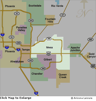
The Mesa, Arizona area map provides a detailed overview of one of the largest and most accessible cities in the East Valley of the Phoenix metropolitan area. Spanning nearly 140 square miles, Mesa features a well-planned grid system of major roadways, including US 60 (Superstition Freeway) and Loop 202, making navigation simple for visitors exploring the region. With a population now approaching 520,000 residents and steady long-term growth of over 3% since 2020, the city of Mesa continues to expand both residentially and commercially. This map highlights key districts, parks, lakes, and access routes, offering a valuable reference for locating attractions, outdoor recreation areas, and nearby destinations throughout the rapidly growing East Valley corridor. This Mesa area map also helps visitors plan day trips, explore nearby cities, and locate popular attractions throughout the East Valley of the Phoenix metro area.
Mesa AZ Road Map Highlights
- US 60 (Superstition Freeway) – primary east/west corridor
- Loop 202 Red Mountain Freeway – access to Phoenix & airport
- Loop 101 Freeway - primary north/south corridor
- Access routes to Saguaro Lake, Canyon Lake & Apache Trail
- I-10 Freeway - travel to Tucson
- I-17 Freeway - travel to Flagstaff, Sedona and Prescott
- State Route 87 - Travel to Payson
Things to Do in Mesa & Nearby
Mesa offers an exceptional mix of outdoor recreation, cultural attractions, and easy access to some of Arizona’s most iconic destinations. Visitors and residents alike enjoy exploring the scenic beauty of Usery Mountain Regional Park and the nearby Salt River, both popular for hiking, kayaking, and wildlife viewing. The city is home to family-friendly attractions like the Arizona Museum of Natural History and the Mesa Arts Center, one of the largest arts complexes in the region. Golfers can choose from numerous championship courses, while spring visitors can catch MLB action during Cactus League Spring Training. Just a short drive away, outdoor enthusiasts can explore nearby Saguaro Lake, Canyon Lake, Apache Trail, and the stunning landscapes of the Sonoran Desert, making Mesa a perfect base for year-round adventure.
Mesa Area Interactive Map
View Larger Map
Surrounding Cities in the Mesa East Valley
The Mesa area is part of the rapidly growing East Valley region of the Phoenix metropolitan area, which includes several major cities known for dining, shopping, resorts, and outdoor recreation. These nearby communities are all within a short drive and are commonly explored together.
- Chandler: Known for shopping centers, restaurants, and tech industry growth
- Gilbert: Popular for its downtown dining district and family-friendly atmosphere
- Tempe: Home to Arizona State University, Tempe Town Lake, and nightlife
- Apache Junction: Gateway to the Superstition Mountains and Apache Trail
- Scottsdale: Upscale resorts, golf, nightlife, and desert recreation
Best Time to Visit Mesa Arizona
The best time to visit Mesa depends on the type of activities you want to enjoy, with cooler months offering ideal outdoor conditions and summer providing opportunities for water recreation and resort stays.
Spring (March – May)
- One of the best seasons for hiking, golf, and outdoor activities
- Perfect weather and blooming desert landscapes
- Popular time for spring training baseball
Summer (June – August)
- Hot desert temperatures, often exceeding 100°F
- Best for lakes, water parks, and indoor attractions
- Fewer crowds and lower hotel rates
Fall (September – November)
- Cooling temperatures and excellent outdoor conditions
- Great time for hiking and exploring nearby lakes
- Less crowded than spring
Winter (December – February)
- Mild weather attracts visitors from colder climates
- Ideal for golf, hiking, and sightseeing
- Peak tourist season in the Phoenix area
Travel & Driving Tips for Mesa and the East Valley
- Use Loop 202 and US 60 for the fastest access across Mesa and surrounding cities
- Plan travel outside of rush hours for easier navigation
- Carry water during warmer months, especially when exploring outdoor areas
- Use Mesa as a base for day trips to lakes, mountains, and desert attractions
- Watch for seasonal traffic during spring training and winter tourism months
Mesa Area Map FAQ
Where is Mesa located in Arizona?
Mesa is located in central Arizona within the East Valley of the Phoenix metropolitan area, just east of Phoenix and near cities like Tempe, Chandler, and Gilbert.
What cities are near Mesa Arizona?
Cities near Mesa include Chandler, Gilbert, Tempe, Apache Junction, Scottsdale, and Phoenix, all within a short driving distance.
What highways run through Mesa?
Major highways include US 60 (Superstition Freeway), Loop 202 (Red Mountain Freeway), and Loop 101, providing access throughout the Phoenix metro area.
What are the best attractions near Mesa?
Popular attractions include Usery Mountain Regional Park, Saguaro Lake, Canyon Lake, the Salt River, Mesa Arts Center, and spring training baseball stadiums.
Is Mesa a good place to stay when visiting Phoenix?
Yes, Mesa is a great base for exploring the Phoenix metro area, offering easy access to major highways, nearby cities, outdoor recreation, and popular attractions.
Related Mesa Interest
Mesa Arizona
Mesa Map
Mesa Casinos
Mesa Lake Tours
Metro Phoenix


