

Apache Junction Map & Directions
Last updated on .
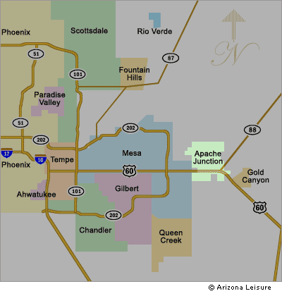
Use this Apache Junction Arizona map to find major highways, driving routes, nearby lakes, and access points to the Superstition Mountains and Apache Trail.
How To Get To Apache Junction
The Apache Junction Arizona area map highlights key highways, scenic routes, and nearby destinations that provide easy access to this popular desert gateway. Located just east of Phoenix and Mesa, Apache Junction is primarily reached via U.S. Route 60 (Superstition Freeway), with additional access from State Route 88, known as the Apache Trail. This map helps visitors navigate the region’s layout, including major roads, nearby lakes, and access points into the Superstition Mountains and Tonto National Forest.
Driving Distances To Apache Junction Arizona
- Phoenix to Apache Junction: About 35 miles east via US-60 (Superstition Freeway).
- Scottsdale to Apache Junction: About 22 miles depending on route.
- Mesa to Apache Junction: About 15 miles east via US-60.
- Tempe to Apache Junction: About 25 miles east.
- Tucson to Apache Junction: About 110 miles north via Interstate 10.
From Phoenix. Take Interstate 10 East and merge into Interstate 60 East and exit North on Power Road. Continue North on Power Road to Apache Trail (Main Street). Turn East (right) on Apache Trail to Apache Junction.
From Scottsdale. Take Loop 101 South to Interstate 60. Merge East on I-60. Exit North on Power Road. Continue North on Power Road to Apache Trail (Main Street). Turn East (right) on Apache Trail to Apache Junction.
From East Valley Cities. (Tempe, Mesa, Gilbert, Chandler) Take Interstate 60 East and exit North on Power Road. Continue North on Power Road to Apache Trail (Main Street). Turn East (right) on Apache Trail to Apache Junction.
Major Highways Near Apache Junction
- U.S. Route 60 (Superstition Freeway): The primary east-west highway connecting Apache Junction to Phoenix and the East Valley.
- State Route 88 (Apache Trail): A scenic route leading into the Superstition Mountains and toward Canyon Lake and Apache Lake.
- Interstate 10: Main route connecting the region to Tucson and southern Arizona.
- Loop 202 & Loop 101: Provide access from Phoenix, Tempe, Scottsdale, and surrounding metro areas.
Nearby Attractions and Destinations
- Lost Dutchman State Park: Popular for hiking, camping, and views of the Superstition Mountains.
- Apache Trail Scenic Drive: One of Arizona’s most famous scenic drives through desert canyons and mountain landscapes.
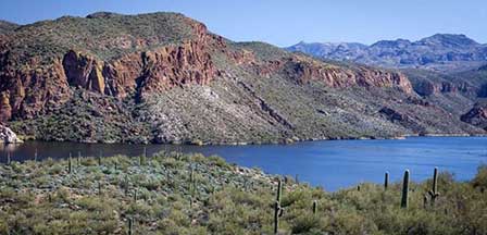
- Canyon Lake: A popular boating, fishing, and sightseeing destination along the Apache Trail.
- Apache Lake: A more remote lake known for fishing, camping, and scenic desert views.
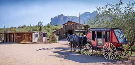
- Goldfield Ghost Town: A recreated Old West town with shops, tours, and family attractions.
- Salt River Recreation Area: Tubing, kayaking, and wildlife viewing opportunities west of Apache Junction.
- Phoenix Metro Area: Dining, shopping, sports, and entertainment just a short drive away.
Apache Junction Area Lakes
- Canyon Lake: The closest major lake, popular for boating, fishing, kayaking, and scenic canyon views.
- Apache Lake: A quieter, more remote lake along the Apache Trail with fishing and camping.
- Roosevelt Lake: A larger lake further along the route, known for boating, fishing, and camping.
- Saguaro Lake: Located west of Apache Junction with boating, fishing, and desert scenery.
Google Map of Apache Junction Arizona
View Larger Map
Apache Junction Map FAQ
Where is Apache Junction Arizona located?
Apache Junction is located in central Arizona, east of Phoenix and Mesa, near the base of the Superstition Mountains.
How far is Apache Junction from Phoenix?
Apache Junction is about 35 miles east of downtown Phoenix via U.S. Route 60.
What highway goes to Apache Junction?
U.S. Route 60 (Superstition Freeway) is the primary highway, with State Route 88 (Apache Trail) providing scenic access into the mountains.
What is Apache Junction known for?
Apache Junction is known for the Superstition Mountains, Apache Trail, Lost Dutchman State Park, and nearby lakes like Canyon Lake.
Is Apache Junction near Mesa Arizona?
Yes, Apache Junction borders Mesa and is only about 15 miles east.
What lakes are near Apache Junction?
Nearby lakes include Canyon Lake, Apache Lake, Saguaro Lake, and Roosevelt Lake.
Can you drive the Apache Trail?
Yes, the Apache Trail is a scenic drive, though some sections may be unpaved or restricted depending on conditions.
Related Apache Junction Interest
Apache Junction Arizona
Apache Trail
Apache Junction Horseback Riding
Apache Junction Map
Apache Junction Renaissance Festival
Fishing Near Apache Junction
Goldfield Ghost Town
Lost Dutchman Mine
Lost Dutchman State Park
Superstition Mountain
Metro Phoenix


