Tucson Arizona Area Map & Attractions
Updated by AZ Leisure Staff Writers on
This Tucson Arizona area map helps visitors locate major attractions, parks, scenic drives, historic sites and day-trip destinations throughout Tucson and Southern Arizona. Use it to plan routes to Saguaro National Park, Sabino Canyon, Mount Lemmon, San Xavier del Bac Mission, the Arizona-Sonora Desert Museum and other popular destinations around the Tucson Basin.
- Tucson Area Map
- Tucson City Map
- Why Visit Tucson
- Top Attractions
- Scenic Drives
- Day Trips
- Map Tips
- FAQ
Why Visit Tucson Arizona
Tucson attracts visitors with Sonoran Desert scenery, mountain landscapes, cultural attractions and year-round outdoor recreation. The region offers hiking, biking, scenic drives, museums, historic landmarks, golf, wildlife viewing and access to destinations such as Saguaro National Park, Sabino Canyon and Mount Lemmon.
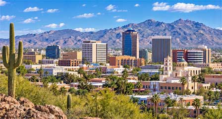
Because Tucson's attractions are spread across a large metropolitan and desert area, an area map is especially useful for grouping nearby destinations and planning efficient sightseeing routes.
Tucson City Map
Interactive Tucson Arizona Area Map
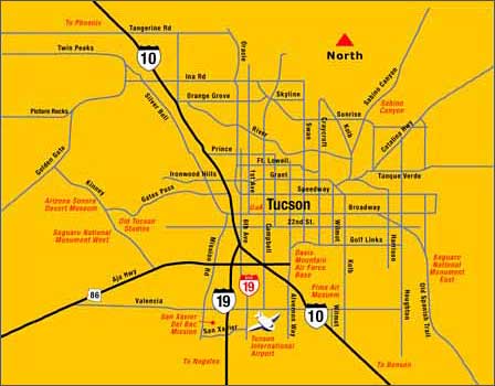
Use the interactive Tucson map to zoom in on neighborhoods, locate nearby attractions and explore driving routes. Select a location to view additional details or open Google Maps for directions. The map can help plan trips between downtown Tucson, Saguaro National Park, Sabino Canyon and surrounding Southern Arizona destinations.
Top Attractions Near Tucson Arizona
Tucson's major attractions range from giant saguaro forests and mountain canyons to historic missions, museums and scenic drives. Many are located outside downtown Tucson, making an area map especially useful when planning a full day of sightseeing.
- Saguaro National Park: Explore giant saguaro forests, scenic drives, desert trails and classic Sonoran Desert scenery in districts east and west of Tucson.
- Sabino Canyon Recreation Area: Popular for hiking, canyon scenery, desert wildlife and access to the Santa Catalina Mountains.
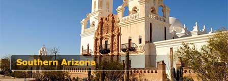
- San Xavier del Bac Mission: Visit one of Southern Arizona's most important historic, cultural and architectural landmarks.
- Arizona-Sonora Desert Museum: Explore a combination zoo, botanical garden, natural history museum and aquarium focused on the Sonoran Desert.
- Mount Lemmon Scenic Byway: Drive from desert terrain into cooler mountain forests, scenic overlooks and seasonal recreation in the Santa Catalina Mountains.
Best Scenic Drives Near Tucson
- Mount Lemmon Scenic Byway: Climb from Sonoran Desert scenery into cooler mountain forests, scenic overlooks and seasonal recreation in the Santa Catalina Mountains.
- Gates Pass Road: Enjoy dramatic desert views, sunsets and access to Tucson Mountain Park and west-side attractions.
- Saguaro National Park Scenic Drives: Explore the paved Cactus Forest Scenic Loop Drive in the Rincon Mountain District east of Tucson or the unpaved Bajada Loop Drive in the Tucson Mountain District west of the city. Road conditions and vehicle restrictions may vary.
- Oracle Road Toward Catalina: Head north toward Oro Valley, Catalina State Park and broad views of the Santa Catalina Mountains.
Best Day Trips From Tucson Arizona
- Saguaro National Park: Visit the east or west district for hiking, scenic drives, photography and iconic Sonoran Desert scenery.
- Sabino Canyon Recreation Area: Enjoy hiking, canyon views, seasonal water and access to the Santa Catalina Mountains.
- Tombstone: Explore a historic Old West town with museums, frontier history and walkable historic streets.
- Kartchner Caverns State Park: Take guided tours through impressive living limestone caverns near Benson.
- San Xavier del Bac Mission: Visit one of Southern Arizona's most significant historic and cultural landmarks.
Tips For Using The Tucson Area Map
- Use the map to compare distances between downtown Tucson, Saguaro National Park, Sabino Canyon, and west-side attractions.
- Plan extra driving time when crossing the Tucson metro area, especially during commuter traffic or major events.
- Check elevation and weather changes before driving to Mount Lemmon, where temperatures can be much cooler than Tucson.
- Group nearby attractions together, such as the Arizona-Sonora Desert Museum, Tucson Mountain Park, and Saguaro National Park West.
- For outdoor activities, start early in warmer months and carry plenty of water for desert travel.
Tucson Arizona Area Map FAQ
What does the Tucson area map show?
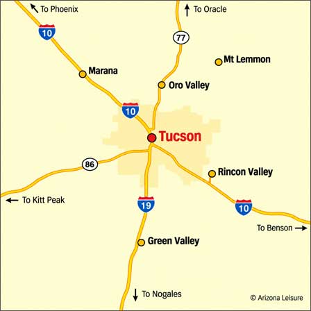
The Tucson area map shows major highways, including I-10, I-19, State Route 77 and State Route 86, along with nearby communities such as Marana, Oro Valley, Green Valley and Rincon Valley. The interactive map provides additional detail for exploring Tucson attractions, parks and sightseeing routes.
What are the top attractions near Tucson?
Popular attractions include Saguaro National Park, Sabino Canyon Recreation Area, San Xavier del Bac Mission, the Arizona-Sonora Desert Museum and Mount Lemmon.
Is Tucson close to Saguaro National Park?
Yes. Saguaro National Park has two districts on opposite sides of Tucson: the Tucson Mountain District west of the city and the Rincon Mountain District to the east.
What are good day trips from Tucson?
Popular day trips include Tombstone, Kartchner Caverns State Park, Bisbee, Tubac, San Xavier del Bac Mission and scenic drives into the Santa Catalina Mountains.
When is the best time to visit Tucson?
Fall, winter and spring generally offer the most comfortable weather for sightseeing, hiking, scenic drives and outdoor recreation. Summer temperatures can be very hot, so early morning and evening are usually best for outdoor activities.
What scenic drives are near Tucson?
Popular scenic routes include the Mount Lemmon Scenic Byway, Gates Pass Road and scenic drives through both districts of Saguaro National Park.
How far is Mount Lemmon from Tucson?
Mount Lemmon is approximately 40 to 45 miles from downtown Tucson by road, depending on the destination. The drive follows Catalina Highway into the Santa Catalina Mountains, climbing from Sonoran Desert terrain into cooler mountain forests. Allow approximately 1 to 1.5 hours each way, depending on traffic, weather and sightseeing stops.
Can the Tucson map help plan a one-day sightseeing route?
Yes. The map can help group attractions by area, such as Saguaro National Park West with the Arizona-Sonora Desert Museum and Tucson Mountain Park, or Sabino Canyon with other east-side destinations.
Related Tucson Interest
Tucson Arizona
Colossal Cave Arizona
Kartchner Caverns
Kartchner Caverns Formation-Creation
Saguaro National Park
San Xavier Del Bac Mission
Tucson Area Map
Tucson Bed & Breakfasts
Tucson Jeep & Hummer Tours
Tucson Pictures
Tucson Weather Info
Southern Arizona Destinations