

San Francisco Peaks Scenic Loop Drive Near Flagstaff
Updated by AZ Leisure Staff Writers on
The San Francisco Peaks Scenic Loop Drive is one of the best mountain drives near Flagstaff, Arizona, circling the state's highest mountain through ponderosa pine forests, aspen groves, open meadows and broad views of the surrounding high country. The roughly 44-mile route combines paved highways with maintained Forest Service roads and can usually be enjoyed in a few hours when road and weather conditions are favorable.
The loop travels through the Flagstaff Ranger District of the Coconino National Forest and provides access to picnic areas, wildlife habitat, forest roads and changing seasonal scenery around the San Francisco Peaks. Summer greenery and wildflowers, autumn aspen color and sweeping mountain views make the drive especially popular from late spring through fall.
- Scenic Loop Quick Facts
- Things To See & Do
- Route & Directions
- Road Conditions
- Best Time To Drive
- Wildlife & Scenery
- Picnic, Hiking & Stops
- Peaks Loop Map
- Driving Tips
- FAQ
San Francisco Peaks Scenic Loop Quick Facts
- Location: North and northwest of Flagstaff, Arizona
- Approximate distance: 44 miles
- Driving time: About 2 to 3 hours without lengthy stops
- Main highways: U.S. 89 and U.S. 180
- Forest roads: Forest Roads 418 and 151
- Surface: Combination of paved highway and gravel forest roads
- Region: Coconino National Forest, Flagstaff Ranger District
- Major landmark: San Francisco Peaks
- Popular seasons: Late spring, summer and fall
- Winter access: Forest-road sections can close because of snow, mud or seasonal conditions
So, pack a picnic lunch for your group and get ready for some outstanding views as you wind through pine forests, aspen groves, open prairies and some rustic homesteads. Anytime is a great time to experience this drive in Northern Arizona's cool and refreshing high country. However, the roads are closed during most of the winter months from late November to early March. During the heavy snowfall season, you might consider snowmobiling the loop.
Things To See & Do Along The San Francisco Peaks Scenic Loop
- Enjoy panoramic views of the San Francisco Peaks and Humphreys Peak
- Drive through ponderosa pine forests and aspen groves
- Cross open high-country meadows and prairie landscapes
- Stop at safe pullouts for mountain and forest photography
- Watch for elk, deer, birds and other Arizona wildlife
- Enjoy fall aspen color during favorable autumn conditions
- Take short hikes from nearby forest access points
- Picnic at appropriate roadside or recreation areas
- Explore Forest Roads 418 and 151 when open and dry
- Combine the loop with other Flagstaff and San Francisco Peaks attractions
Wildlife, Wildflowers & Fall Color
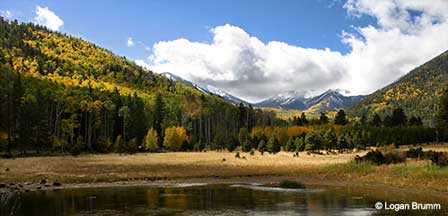
Seasonal scenery changes dramatically around the San Francisco Peaks. Spring and early summer can bring wildflowers and fresh vegetation, while summer offers green forests and open meadows. Fall is especially popular when aspen groves turn shades of yellow and gold against the darker conifer forests.
Wildlife sightings may include elk, mule deer, birds and smaller forest animals. Observe wildlife from a safe distance and never stop in a travel lane to take photographs.
Picnic Stops, Short Hikes & Forest Recreation
The loop offers opportunities to stop at safe pullouts, picnic areas and nearby forest recreation sites. Bring food, water and layers so you can spend time enjoying the scenery rather than simply driving the route.
Hiking, biking and dispersed camping are available in parts of the surrounding Coconino National Forest, but visitors should use only roads, trails and camping areas currently designated for those activities. Check the current Motor Vehicle Use Map and posted restrictions before leaving the main loop roads.
San Francisco Peaks Scenic Loop Route & Directions
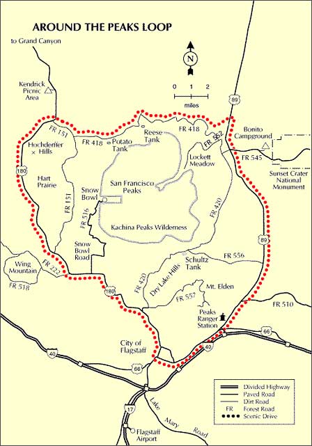
From Flagstaff, travel northeast on U.S. 89 approximately 14 miles to Forest Road 418. Turn west on Forest Road 418 and continue roughly 12 miles to Forest Road 151. Follow Forest Road 151 south for about 8 miles to U.S. 180, then return approximately 9.5 miles to Flagstaff.
The complete drive is about 44 miles. Allow at least 2 to 3 hours, and considerably longer if you stop for photographs, hiking, wildlife viewing or a picnic.
Best Time To Drive The San Francisco Peaks Loop
- Spring: Road access can vary with lingering snow, mud and thaw conditions.
- Summer: Excellent for green forests, wildflowers and cooler mountain temperatures.
- Fall: One of the most popular times because of colorful aspen foliage.
- Winter: Forest-road sections are often closed or unsuitable because of snow and wet conditions.
Road Conditions & Vehicle Considerations
U.S. 89 and U.S. 180 are paved highways. Forest Roads 418 and 151 are unpaved forest roads that may be suitable for standard passenger vehicles when dry and properly maintained, but conditions can change quickly after snow, rain or heavy traffic.
Do not rely on a fixed seasonal opening date. Before driving the loop, check current Coconino National Forest road conditions, weather, fire restrictions and temporary closures. Higher-elevation roads may remain closed or muddy well into spring.
For More Information
Current Forest Information
Coconino National Forest
Flagstaff Ranger District
Phone: 928-526-0866
For current road closures, fire restrictions, seasonal access and travel maps, check the Coconino National Forest before beginning the drive.
Where To Stay Near The Scenic Loop
Flagstaff is the most convenient base for driving the San Francisco Peaks loop, with hotels, motels, bed and breakfast inns, RV parks, cabins and vacation rentals. Staying in Flagstaff also makes it easy to combine the drive with Arizona Snowbowl, historic downtown, Lowell Observatory and other northern Arizona attractions.
San Francisco Peaks Scenic Loop Map
San Francisco Peaks Scenic Loop Driving Tips
- Check Forest Service road conditions before leaving Flagstaff.
- Avoid unpaved forest roads when they are muddy or snow-covered.
- Carry drinking water, snacks and seasonal clothing.
- Keep your fuel tank adequately filled before entering remote forest roads.
- Expect limited cell service in some areas.
- Use designated pullouts rather than stopping in travel lanes.
- Watch carefully for wildlife crossing the road.
- Reduce speed on gravel sections and around blind curves.
- Check current fire restrictions before planning a picnic or dispersed camping.
- Allow extra time during fall-color weekends when traffic can be heavier.
San Francisco Peaks Scenic Loop FAQ
How Long Is The San Francisco Peaks Scenic Loop Drive?
The loop is approximately 44 miles and generally takes about 2 to 3 hours without lengthy stops.
Where Does The San Francisco Peaks Loop Start?
Most visitors begin in Flagstaff and use U.S. 89, Forest Road 418, Forest Road 151 and U.S. 180 to complete the loop.
Is The Entire Scenic Loop Paved?
No. U.S. 89 and U.S. 180 are paved, while Forest Roads 418 and 151 include unpaved gravel sections.
Can A Passenger Car Drive The Peaks Loop?
Passenger cars may be suitable when the forest roads are dry, open and in good condition, but road conditions should always be checked before travel.
When Is The Best Time To Drive The San Francisco Peaks Loop?
Late spring through fall generally offers the best conditions, with autumn especially popular for aspen color.
Is The Peaks Loop Open In Winter?
Forest-road portions are often closed or unsuitable during winter because of snow, ice and wet conditions. Closure dates vary each year.
Where Can You See Fall Color Near Flagstaff?
Aspen groves around the San Francisco Peaks can produce excellent fall color, making this loop one of the popular autumn drives near Flagstaff.
Can You Camp Along The Scenic Loop?
Dispersed camping is available only where current Coconino National Forest rules and motor-vehicle designations allow it. Check current maps and restrictions first.
Are There Hiking Opportunities Along The Loop?
Yes. Numerous forest roads, trailheads and recreation areas around the San Francisco Peaks provide hiking opportunities near the scenic drive.
What Should I Check Before Driving The Loop?
Check current weather, Forest Service road conditions, seasonal closures and fire restrictions before starting the drive.
More Flagstaff Scenic Drives & Mountain Attractions
- Flagstaff Arizona Visitor Guide
- San Francisco Peaks
- Humphreys Peak
- Arizona Snowbowl
- Snowbowl Scenic Drive
- Schultz Pass Road
- Flagstaff Area Map & Directions
- Flagstaff Weather & Climate
- Flagstaff Camping
- Flagstaff Photo Gallery
Flagstaff High Country
Enjoy Cool Flagstaff
Flagstaff Arizona
Map & Directions
Weather & Climate
Miles to Arizona Cities
Picture Gallery
Distance To Attractions
About Flagstaff AZ
Lakes Near Flagstaff
Blue Ridge Reservoir
Upper Lake Mary
Mormon Lake
Kinnikinick Lake
Ashurst Lake
Flagstaff Fishing
Scenic Drives
Oak Creek Canyon
Arizona Route 66
Peaks Loop Drive
Schultz Pass Road
Snowbowl Scenic Drive
Things To Do
Scenic Railways
Cliff Castle Casino
Snow Skiing
Flagstaff Camping
Flagstaff Museums
Area Attractions
Lake Powell
Wupatki Ruins
San Francisco Peaks
Grand Canyon
Walnut Canyon
Humphreys Peak
Meteor Crater
Sunset Crater
Historic Downtown
Arizona Snowbowl
Lowell Observatory
Arboretum of Flagstaff
Where To Stay
Cabin Rentals
RV Parks & Campgrounds
Bed and Breakfast
Conifer House
Aspen Inn
Flagstaff Articles
Kids Snow Play
Dress For Flagstaff
Nearby Cities
Williams Arizona















