
Canyon De Chelly National Monument
Last updated on .
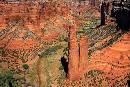 Spider Rock at Canyon De Chelly. © Mike Koopsen
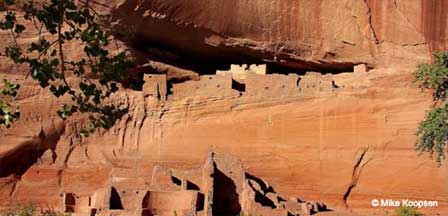
Located near Chinle, Arizona, Canyon de Chelly National Monument is one of the most unique and culturally significant landscapes in the American Southwest. Unlike most national park sites, the canyon is still home to Navajo families who live, farm, and raise livestock on the canyon floor. Towering red rock walls rise more than 1,000 feet above ancient cliff dwellings, including the famous White House Ruins and the iconic Spider Rock formation, making Canyon de Chelly a must-see destination for history, photography, and scenic desert exploration.
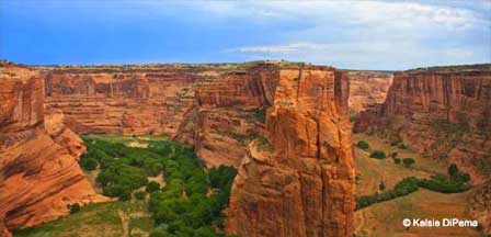
The Canyon de Chelly National Monument [du shA´] consists of many well-preserved Anasazi ruins and spectacular sheer red cliffs that rise up to 1000 feet. A trip to the monument offers visitors a chance to learn about the people who lived there in ancient days as well as those who live in the canyon today.
Why Visit Canyon de Chelly National Monument
Canyon de Chelly offers a rare combination of natural beauty, ancient history, and living culture that cannot be found anywhere else in Arizona. Visitors can explore well-preserved Ancestral Puebloan ruins, view dramatic sandstone cliffs, and experience Navajo traditions that continue today within the canyon. Scenic rim drives provide easy access to overlooks, while guided tours allow deeper exploration of the canyon floor. Whether you’re interested in photography, hiking, history, or cultural experiences, Canyon de Chelly delivers one of the most meaningful and visually striking destinations in the Southwest.
The Anasazi - "Ancient Ones" - lived in the canyon between 350 and 1300 AD and resided in communities nestled below the towering cliffs or perched on high ledges. Their homes were engineered using timbers and adobe-style bricks. The most impressive structures are large cliff dwellings, built between 1100 and 1300 in the Pueblo period. The Anasazi left the area around 1300. The reason for their disappearance is debated with the most popular theory being a prolonged drought that forced them out. The people of Canyon de Chelly and other nearby Pueblo centers left their homes and moved to other parts of the Southwest. Some of the present-day Pueblo Indians of Arizona and New Mexico are descendants of these pre-Columbian people.
The Hopi and Pueblo Indians are believed to be the most closely related to the Anasazi. The Hopi lived in Canyon de Chelly at some time between 1300 and 1700.
The Navajo, related culturally and linguistically to the various Apache Indians in the Southwest, moved from northern New Mexico into the area around 1700. In the 1700s and 1800s they recorded the arrival of the Spaniards and the introduction of cows, horses and sheep into the area.
The Navajo fought with the Pueblo Indian villages and Spanish settlements along the Rio Grande Valley. As a result, the Spanish, Mexican, and American governments conducted their own battles with the Navajo. As a Navajo stronghold, Canyon de Chelly figured prominently.
Today, some 80 families still live in the canyon where they farm and raise animals. Visitors can see the working farms and the traditional Navajo houses six or eight-sided hogans with the doors facing east to greet the sun every morning.

Best Things To Do & See Near Canyon de Chelly National Monument
Spider Rock Overlook
- View the iconic sandstone spire rising nearly 800 feet from the canyon floor
- One of the most photographed landmarks in northeastern Arizona
- Best visited in early morning or late afternoon for lighting
White House Ruins Trail
- Moderate 2.5-mile round-trip hike descending into the canyon
- Only self-guided trail that allows access to the canyon floor
- Leads to one of the best-preserved Ancestral Puebloan cliff dwellings
South Rim Drive
- Scenic drive with multiple overlooks including Spider Rock
- Easy access to major viewpoints along paved roads
- Ideal for photography and sightseeing
North Rim Drive (Canyon del Muerto)
- Explore overlooks into Canyon del Muerto
- View ancient ruins and dramatic canyon formations
- Less crowded than the South Rim drive
Guided Navajo Tours
- Required for most canyon floor access beyond White House Trail
- Available by jeep, horseback, or hiking tours
- Provides cultural insight and access to hidden sites
Camping & Scenic Views
- Free campground available near the visitor center
- Enjoy quiet desert nights and star-filled skies
- Excellent base for sunrise and sunset photography
An excellent way to view Canyon de Chelly Arizona is to hike the moderate, 2.5-mile White House Ruins trail, which descends 600 feet to the canyon floor.
To hike anywhere else in the canyons, visitors must be accompanied by an authorized guide. Guided tours are offered on foot or horseback or on four-wheel-drive vehicles.
Visitors also can view Canyon de Chelly and Canyon del Muerto by driving along the north and south rim drives.
Best Times To Visit Canyon de Chelly
Spring (March – May)
- Comfortable temperatures and ideal hiking conditions
- Green vegetation contrasts beautifully with red canyon walls
- One of the best seasons for photography
Summer (June – August)
- Hot daytime temperatures with cooler mornings and evenings
- Afternoon monsoon storms can create dramatic skies
- Plan outdoor activities early or late in the day
Fall (September – November)
- Mild weather and fewer visitors than summer
- Excellent conditions for scenic drives and hiking
- Great time for photography and cultural tours
Winter (December – February)
- Cool temperatures with occasional snow dusting canyon walls
- Very quiet and peaceful with minimal crowds
- Best for scenic views and solitude rather than hiking
Canyon de Chelly National Monument provides campsites at no charge on a first come basis. Groups of 15 or more people can make reservations by contacting the monument.
Canyon de Chelly National Monument FAQ
Where is Canyon de Chelly located?
Canyon de Chelly National Monument is located in northeastern Arizona near Chinle on the Navajo Nation.
Is Canyon de Chelly free to visit?
Yes. Entrance to Canyon de Chelly National Monument is free, including scenic rim drives and overlooks.
Can you hike into Canyon de Chelly?
Visitors can hike the White House Ruins Trail without a guide. All other canyon floor access requires a Navajo guide.
What is the most famous landmark in Canyon de Chelly?
Spider Rock is the most famous landmark, rising dramatically from the canyon floor and visible from the South Rim Drive.
How long should you spend at Canyon de Chelly?
Most visitors spend half a day to a full day exploring scenic drives, overlooks, and the White House Ruins Trail.
Are guided tours required?
Guided tours are required for most canyon floor areas beyond the White House Ruins Trail and provide deeper cultural insight.
How to Get to Canyon de Chelly National Monument
Canyon de Chelly National Monument is located near Chinle in northeastern Arizona on the Navajo Nation. The monument is accessible by car via Arizona State Route 191 and is most easily reached from several major cities across Arizona and the Southwest.
Driving from Flagstaff, Arizona
- Distance: Approximately 185 miles
- Drive Time: About 3 to 3.5 hours
- Route: U.S. Route 89 North to U.S. Route 160 East, then AZ-191 North to Chinle
Driving from Phoenix, Arizona
- Distance: Approximately 300 miles
- Drive Time: About 5 to 5.5 hours
- Route: Interstate 17 North to Flagstaff, then U.S. Route 89 North and U.S. Route 160 East to AZ-191
Driving from Page, Arizona
- Distance: Approximately 110 miles
- Drive Time: About 2 to 2.5 hours
- Route: U.S. Route 98 South to U.S. Route 160 East, then AZ-191 North
Driving from Albuquerque, New Mexico
- Distance: Approximately 230 miles
- Drive Time: About 4 to 4.5 hours
- Route: Interstate 40 West to Gallup, then U.S. Route 491 North and U.S. Route 191 North
Travel Tips
- Fuel up before arriving in Chinle, as services are limited in remote areas
- Cell service can be limited on Navajo Nation roads
- Watch for livestock and slower traffic on rural highways
- Check weather and road conditions before traveling, especially in winter
Canyon de Chelly National Park
P.O. Box 558
Chinle, Arizona 86503
(928) 674-5000 or 5510
More Information & Reading
www.discovernavajo.com
Indian Ruins In Arizona
Arizona Indian Ruins
Canyon de Chelly
Casa Grande Ruins
Montezuma Castle
Map & Directions Montezuma Castle
Montezuma Well
Palatki Indian Ruins
Pueblo Grande
Walnut Canyon
Wupatki Ruins
Related Canyon de Chelly Interest
Canyon de Chelly
Canyon de Chelly Campground
Canyon de Chelly Photos & Videos
Canyon de Chelly Visitor Info
Map & Directions Canyon de Chelly
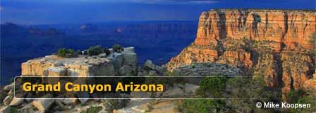
The Spectacular Grand Canyon


