


Arizona Distance Guide
Updated by AZ Leisure Staff Writers on
Driving Distances Between Arizona Cities & Destinations
Whether you're planning a weekend getaway, a scenic Arizona road trip or a cross-state vacation, knowing the driving distance between destinations can make travel planning much easier. This Arizona Distance Guide includes approximate driving mileage between many of the state's most popular cities, national parks, lakes and attractions. Use the mileage chart and distance map to estimate travel times, organize multi-stop itineraries and discover nearby destinations that can easily be combined into one memorable Arizona vacation.
- Arizona Mileage Chart
- How To Use The Distance Map
- Estimated Driving Times
- Popular Arizona Road Trips
- Arizona Driving Tips
- Arizona Distance Guide FAQ
- Additional Arizona Maps
Arizona Mileage Chart
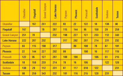
Find distances, in miles, between cities in Arizona. This will help tourists and vacationers plan their getaway vacation. All distances are estimates depending upon travel routes, starting point and attraction destination. Driving times depend upon how fast you drive, traffic at peak travel times, and any road construction you may encounter.
How To Use the Arizona Distance Map
Use this Arizona distance guide to compare approximate driving mileage between major cities, scenic regions, and popular vacation destinations. Distances can vary depending on the route selected, road conditions, traffic, construction, and whether you choose scenic highways or faster interstate routes.
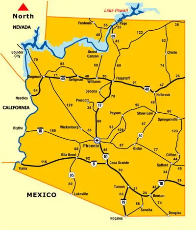
Arizona mileage map showing approximate driving distances between major cities, national parks and popular vacation destinations.
Estimated Arizona Driving Times
Although mileage provides a good estimate of travel distance, actual driving time depends on highway speed limits, traffic, road construction, weather conditions and the number of scenic stops along the way. Interstate highways generally allow faster travel than mountain roads and scenic byways.
- Phoenix to Sedona: approximately 2 hours
- Phoenix to Flagstaff: approximately 2½ hours
- Phoenix to Grand Canyon South Rim: approximately 3½ to 4 hours
- Flagstaff to Page: approximately 2½ hours
- Phoenix to Tucson: approximately 2 hours
- Phoenix to Show Low: approximately 3½ hours
- Phoenix to Lake Havasu City: approximately 4½ to 5 hours
Arizona Road Trip Planning Tips
Arizona covers more than 113,000 square miles, making travel planning an important part of any vacation. Desert highways, mountain roads and scenic byways often require more travel time than visitors expect, especially when stopping for overlooks, hiking trails and historic attractions.
- Allow extra travel time during holiday weekends.
- Carry drinking water, especially during summer.
- Check mountain weather before driving into northern Arizona.
- Refuel whenever fuel is available in remote areas.
- Watch for wildlife at dawn and dusk.
- Check highway construction before departing.
- Allow extra time for scenic overlooks and photography stops.
Popular Arizona Road Trip Itineraries
Many of Arizona's top attractions are located within comfortable driving distance of one another, making it easy to combine several destinations into a single vacation.
- Phoenix → Sedona → Flagstaff → Grand Canyon
- Phoenix → Payson → Show Low → Greer
- Phoenix → Prescott → Jerome → Sedona
- Flagstaff → Page → Horseshoe Bend → Antelope Canyon
- Phoenix → Tucson → Tombstone → Bisbee
- Las Vegas → Hoover Dam → Lake Havasu City → Parker
Planning Trips Around Nearby Destinations
One of the best ways to experience Arizona is by planning trips that connect destinations located within close driving distance of each other. Many of the state’s top attractions naturally group together, making it easy to build efficient travel itineraries. For example, visitors can combine a trip to the Grand Canyon with nearby stops at Horseshoe Bend and Antelope Canyon, or pair Sedona with Flagstaff and surrounding national monuments. Scenic drives between regions reveal even more hidden gems, from historic Route 66 towns to lakes, forests, and desert parks. By using distance guides and travel maps, visitors can maximize their time, reduce travel fatigue, and experience more of Arizona’s top attractions in a single trip.
Popular Arizona Driving Routes
- Phoenix to Grand Canyon: A popular road trip connecting central Arizona with one of the world’s most famous natural wonders.
- Phoenix to Sedona: A scenic drive from the desert to red rock country.
- Sedona to Flagstaff: A short but beautiful route through Oak Creek Canyon and northern Arizona forest country.
- Flagstaff to Page: A useful route for visiting Lake Powell, Horseshoe Bend, and Antelope Canyon.
- Tucson to Phoenix: A major interstate drive connecting southern and central Arizona.
- Phoenix to Show Low: A scenic drive from the desert into Arizona’s White Mountains region.
Other Distance and Drive Time Information
Google Arizona Map
Arizona Distance Guide FAQ
How far is the Grand Canyon from Phoenix?
The South Rim is approximately 220 to 230 miles from Phoenix, depending on your route.
How far is Sedona from Phoenix?
Sedona is about 115 to 120 miles north of Phoenix.
How far is Flagstaff from Phoenix?
Flagstaff is approximately 145 miles north of Phoenix.
How far is Tucson from Phoenix?
Phoenix and Tucson are approximately 115 miles apart via Interstate 10.
How far is Page from Flagstaff?
The drive is approximately 135 miles.
How far is Lake Havasu City from Phoenix?
Lake Havasu City is approximately 195 to 205 miles from Phoenix.
How far is Show Low from Phoenix?
Show Low is roughly 175 miles northeast of Phoenix.
How far is Monument Valley from Flagstaff?
The drive is approximately 180 miles.
Are Arizona driving distances exact?
No. Distances vary depending on the route selected.
Should I use mileage or driving time?
Both are useful. Mileage measures distance while driving time accounts for road types and speed limits.
Do mountain roads take longer?
Yes. Scenic highways often require additional travel time because of curves, elevation changes and lower speed limits.
When is the best time for an Arizona road trip?
Spring and fall generally provide the most comfortable temperatures throughout most of the state.
Can winter weather affect northern Arizona travel?
Yes. Snow and ice occasionally affect highways near Flagstaff, the White Mountains and the Grand Canyon.
What is the best way to plan an Arizona vacation?
Group nearby destinations together to reduce driving and maximize sightseeing time.
Related Arizona Maps, Distance Guides & Travel Resources
Planning a road trip? These additional Arizona maps and travel guides can help you explore the state's most popular destinations, scenic drives and outdoor recreation areas.
- Arizona State Map – Overview map of cities, highways and major destinations.
- Phoenix Area Map – Streets, freeways and attractions throughout metropolitan Phoenix.
- Sedona Map – Navigate Sedona's scenic highways, red rock attractions and trailheads.
- Flagstaff Map – Local streets, highways and attractions in northern Arizona.
- Grand Canyon Map – Visitor map of the South Rim and surrounding attractions.
- Lake Powell Map – Marinas, recreation areas and boating destinations.
- Arizona Lakes Map – Lakes, reservoirs and popular boating destinations statewide.
- Arizona Road Trips – Scenic drives and suggested vacation itineraries.
- Things To Do In Arizona – Attractions, parks, outdoor recreation and sightseeing.
Most Popular Things To Do In AZ
Additional Arizona Activities















