
San Francisco Peaks
Last updated on .
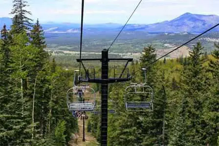 Summer Chairlift Rides. © LABabble
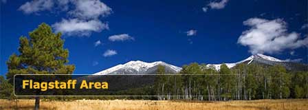
Rising dramatically north of Flagstaff, the San Francisco Peaks are among Arizona’s most iconic natural landmarks and home to the highest mountain in the state. This ancient volcanic range offers year-round recreation with scenic drives, alpine forests, summer chairlift rides, hiking trails, wildlife viewing, brilliant fall color, and winter snow sports. Visitors searching for the best mountain attractions near Flagstaff often choose the Peaks for cool temperatures, panoramic views, and easy access from town.
San Francisco Peaks Near Flagstaff Arizona
Once the fiery center of one of Arizona's most explosive volcanoes, the summits surrounding the now dormant inner core stand guard, protecting land that the native people of Arizona consider to be so sacred it is where earth meets heaven. The Navajo consider them to be the most sacred in all the West and their medicine men use the herbs collected from the mountaintop in healing ceremonies. They view the rising peaks as a holy landmark directing others to this sacred place. The Hopi believe the Kachina spirits live at the top of the mountain, gracefully moving through the clouds from summit to summit. The Kachinas are honored and revered here, in hopes that they will bless the crops below with a quiet rain that will ensure strong growth and healthy lives. The Zuni, Havasupai and Yavapai-Apache also consider these graceful remnants of the volcanic highlands to be sacred and return regularly to pray and honor the spirits that dwell there.
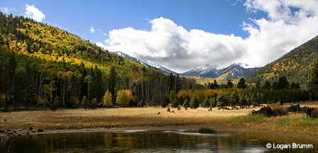
The Peaks. Located just north of Flagstaff, Arizona on U.S. 180, the San Francisco Peaks soar to heights reaching 12,633 feet and serve as one of the most distinct geological features of the Colorado Plateau. Named in honor of St. Francis of Assisi by the Spanish Friars that settled the area in the 1620's, these scenic mountains are known locally as simply the Peaks. Today over a quarter of a million people flock to the Peaks each year for hiking, skiing, camping, wildlife viewing and wilderness solitude.
Why Visit San Francisco Peaks
The San Francisco Peaks deliver one of the most diverse outdoor experiences in northern Arizona. In a single day, visitors can enjoy high-elevation forests, open meadows, scenic overlooks, and views stretching across the Colorado Plateau. The area is especially popular for hiking to Humphreys Peak, exploring the surrounding wilderness, riding the summer scenic lift at Arizona Snowbowl, or enjoying winter skiing and snow play. The Peaks are also culturally significant and considered sacred by several Native American tribes.
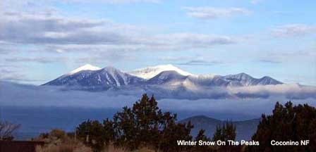
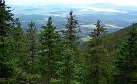 View From Humphreys Trail. Credit: Coconino NF
The Peaks collectively represent six summits that circle the caldera of the now quiet volcano. Humphreys Peak, at 12,633 feet, is the tallest in Arizona. Agassiz Peak soars to 12,356 feet, and Fremont Peak climbs to 11,969 feet. Aubineau Peak, Reese Peak, and Doyle Peak complete the ring, creating both a scenic wonderland and geological display of volcanic rock, deep Alpine forest and lava flows. The Peaks tower so dramatically against the landscape of Flagstaff and surrounding area that they are even visible from the pueblo ruins at Wupatki National Monument, dozens of miles away and on a clear day, you can see the North Rim of the Grand Canyon over eighty miles away as the eagle flies.
Best Things To See Around San Francisco Peaks
- Humphreys Peak – Arizona’s highest summit with unforgettable views.
- Arizona Snowbowl – Scenic chairlift rides, skiing, and mountain activities.
- Inner Basin – Beautiful seasonal drives with aspen groves and fall color.
- Hart Prairie – Meadows, wildflowers, and wildlife viewing.
- Lava River Cave – Unique lava tube adventure nearby.
- Sunset Crater Volcano National Monument – Volcanic landscapes east of the Peaks.
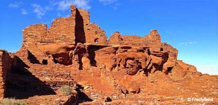
- Wupatki National Monument – Ancient pueblos with Peaks views in the distance.
Best Times To Visit Flagstaff and the San Francisco Peaks
- Spring (March to May) – Excellent for cool weather, fewer crowds, forest scenery, and lower-elevation hiking as snow begins melting. Late spring is ideal for scenic drives and visiting Arizona Snowbowl base area.
- Summer (June to August) – Most popular season for escaping desert heat. Ideal for mountain hiking, wildflowers, chairlift rides, camping, festivals, and daytime temperatures much cooler than Phoenix. Best overall season for outdoor recreation.
- Early Fall (September to October) – One of the top times to visit for crisp air, golden aspen color, clear skies, and outstanding photography. Great for hiking trails around the Peaks and enjoying Flagstaff without peak summer crowds.
- Late Fall (November) – Quiet shoulder season with fewer visitors. Cooler temperatures and occasional early snow create scenic mountain views. Good for relaxed getaways and lodging deals.
- Winter (December to February) – Best season for snow lovers. Prime time for skiing, snowboarding, tubing, and winter scenery at Arizona Snowbowl. Great choice if you want a classic Arizona mountain winter experience.
- Best Overall for Most Visitors – June through October for hiking, scenic beauty, and comfortable weather.
- Best for Snow Activities – December through March, depending on snowfall.
- Best for Fall Color – Late September through mid-October.
- Best for Lower Crowds – April, May, and November.
San Francisco Peaks Hiking, Scenic Drives & Arizona Snowbowl
The Peaks Ranger District has nearly thirty hiking trails, offering something for everyone from the beginning hiker to the advanced backcountry traveler.
Hiking the Peaks. The most adventurous can tackle Humphreys Trail to the highest point in Arizona. This strenuous, 9 mile round trip hike is steep and extremely rocky, particularly in the higher elevations. With the altitude change hikers can expect landscape changes as well. Beginning in pinecone forests, the climb quickly rises above the tree line to tundra like conditions where it can snow any time of the year. During monsoon season flash floods can race down the mountain or fill the air with crackling lightning. Despite nature's challenges, Humphreys Trail remains one of the most heavily traveled in the Peaks.
Those looking for a more relaxed pace might consider Deer Hill Trail. An easy 10 mile round trip, the trail is mostly flat and takes the hiker through both dense forest and vastly open plateaus. In fall the dramatic color display of the aspen trees makes this hike a favorite for nature photographers and artists alike. Open to hikers, equestrians and mountain bikers, this trail provides one of the most scenic views of the Peaks and nearby Sunset Crater.
Little Bear Trail is a moderately difficult 7 mile round trip through ponderosa pine and oak trees, with small amounts of aspen and Douglas-fir as you climb to the higher elevations. This trail is an exceptional one for viewing Peaks area wildlife, particularly mule deer, elk, raven, and even turkey vulture. An occasional black bear has also been spotted along the trail, so it is important to enjoy your wildlife viewing from a distance. One of the Peaks' most popular trails, Little Bear is also open to hikers, equestrians, and mountain bikers.
More San Francisco Peaks Hiking Trails
Kachina Trail
- Hiking, Ski, Equestrian
- (928) 526-0866.
- 5 miles.
- Easy.
- Picturesque, level trail passes through aspen groves and meadows on the way through the southern San Francisco Peaks. Truly an all-season trail. Return via the same way or connect with the Weatherford Trail. Directions: From Flagstaff, drive north on Hwy 180 to the Snow Bowl turnoff. Drive up the mountain 7.5 miles to the lower parking lot at the Snow Bowl, where you'll find the trailhead.
- From Flagstaff, drive north on Hwy 180 to the Snow Bowl turnoff. Drive up the mountain 7.5 miles to the lower parking lot at the Snow Bowl, where you'll find the trailhead.
- Call ahead for maps of connecting trails in the area. Beware of lightning during summer storms in exposed areas. Normally these storms occur in the late afternoon during July and August.
Slate Mountain Trail
- Hiking, Mountain Bike, Equestrian
- (928) 526-0866
- 5 miles roundtrip
- Moderate
- The summit rewards with awesome views of the San Francisco Peaks and the Grand Canyon. The easy-to-follow trail follows an old road, long closed to vehicles. Signs along the way describing the trees and shrubs.
- From Flagstaff, drive north on US180 to Forest Road 191. Turn left. The trailhead is two miles from this point.
- This multi-use trail is open to mountain bikers and horses. No water is available.
Humphrey's Peak Trail
- (928) 526-0866
- 8.7 miles roundtrip
- Difficult
- This trail to the summit winds up the aspen-covered mountain. The last mile, above the tree line, is especially challenging. It becomes windy, steeper and rockier, but once at the top, there are magnificent views of the entire state.
- From Flagstaff, drive north on U.S. 180 for 7 miles to the Snow Bowl Road. It's another 7 miles to the Snow Bowl parking lot. The trailhead is at the north end of the parking lot.
- Humphrey's Peak, at 12,633 feet, is the highest mountain in Arizona. Pay attention to signs of altitude sickness. Do not attempt to go to the top during an electrical storm, which can occur daily during July and August. No water available.
Scenic Drives Around San Francisco Peaks
While just about any road through the Peaks can be considered scenic and offer visitors dramatic views of the soaring mountains, pine forests, volcanic rims, and diverse wildlife, there are four designated scenic drives through the area that offer particularly beautiful views of the backcountry:
Around the Peaks Loop consists of 44 miles of forest service roads that are well maintained and suitable for passenger cars in most weather. The road is closed in winter. Found along FR 418 and FR 151, visitors can enjoy trailheads for hiking and mountain biking, wildlife viewing and dramatic fall color in the pine and aspen forest.
Schultz Pass Road covers 26 miles and provides access for picnicking, hiking and mountain biking as well. Schultz Pass is also closed in winter.
Snowbowl Road is just 15 miles along paved roads that are plowed in winter, taking visitors through the mountain scenery on their way to backcountry hiking, biking, and through exceptional fall color. This is also the road to the Snowbowl Ski Area.
At 70 miles, the Volcanoes and Ruins Loop is the longest scenic drive in the Peaks, and although the roads are paved, can be icy in winter. Here visitors can enjoy picnicking, hiking, wildlife viewing, and get close up views of Indian Ruins and volcanoes.
Winter Activities at San Francisco Peaks
There are several winter activities that take advantage of the natural wonderland offered by the San Francisco Peaks. Visitors can enjoy Nordic and cross-country skiing at the Flagstaff Nordic Center, Wing Mountain and the Snowbowl Ski Area. Snowmobiling is a popular pastime along the many trails found at the Kendrick Snowmobile Trail System. For those just wanting to build a snowman or throw a few snowballs, snow play is available at Wing Mountain and Peakview.
More Outdoor Activities Near San Francisco Peaks
The Peaks are also home to the Elden Pueblo, a dedicated archaeological dig site offering public days where amateur archaeologists can test their skills in search of ruins and artifacts. The Lava River Cave offers dramatic hiking through a lava tube and one of the best scenic views of the entire Peaks area. The Snowbowl Ski Area offers sky rides in summer, using their famed alpine ski lifts to carry visitors to the mountain's heights for fall color viewing, hiking trails and a unique out of season perspective on the alpine climate zone. Off road enthusiasts should not miss the Cinder Hills Off Highway Vehicle Area, open Spring through Fall, where off road vehicles race across the Peaks' designated trails. Camping and backcountry sightseeing are also available here.
How To Get To San Francisco Peaks
The San Francisco Peaks make up such a diverse area in the Coconino Forest that can be accessed from a number of highways and Forest Service roads. From Flagstaff drive north on Highway 180 or 89. From Highway 180, the Snowbowl Road and FR 418 and FR 420 provide access. From US 89, 418 and 420 provide access to lower slopes. FR 552 provides the easiest access to the Inner Basin.
How the Peaks Formed. The volcanic highland area of Arizona began forming over 6 million years ago with the eruption of nearly 600 volcanoes. The most dramatic of those eruptions left the Peaks, and Humphrey's Peak in particular, soaring above the landscape in what otherwise would have been dry, arid plateau. Although most volcanoes form near the edges of the tectonic plates that make up the Earth's crust, Arizona is located far from the boundary of the North American Plate. It is believed that a trapped area of molten rock deep beneath Northern Arizona, called a "hot spot", occasionally rises up and creates volcanoes as the plate moves slowly west. The most recent volcanic eruption was nearly 1,000 years ago at nearby Sunset Crater. The Peaks were formed between 500,000 to 1 million years ago and the inner basin has been quiet ever since.
More Information
Coconino National Forest
1824 S. Thompson St.
Flagstaff, AZ 86001
928-527-3600
Camping in the Peaks District
Snowbowl Ski Resort Area
Other Peak Trail Descriptions
Flagstaff Hotel Accommodations
Flagstaff High Country
Enjoy Cool Flagstaff
Flagstaff Arizona
Map & Directions
Weather & Climate
Miles to Arizona Cities
Picture Gallery
Distance To Attractions
About Flagstaff AZ
Lakes Near Flagstaff
Blue Ridge Reservoir
Upper Lake Mary
Mormon Lake
Kinnikinick Lake
Ashurst Lake
Flagstaff Fishing
Scenic Drives
Oak Creek Canyon
Arizona Route 66
Peaks Loop Drive
Schultz Pass Road
Snowbowl Scenic Drive
Things To Do
Scenic Railways
Cliff Castle Casino
Snow Skiing
Flagstaff Camping
Flagstaff Museums
Area Attractions
Lake Powell
Wupatki Ruins
San Francisco Peaks
Grand Canyon
Walnut Canyon
Humphreys Peak
Meteor Crater
Sunset Crater
Historic Downtown
Arizona Snowbowl
Lowell Observatory
Arboretum of Flagstaff
Where To Stay
Cabin Rentals
RV Parks & Campgrounds
Bed and Breakfast
Conifer House
Aspen Inn
Flagstaff Articles
Kids Snow Play
Dress For Flagstaff
Nearby Cities
Williams Arizona


