


Tempe Arizona Area Map & Nearby Cities
Reviewed and updated by AZ Leisure Staff Writers on
Where Is Tempe Arizona?
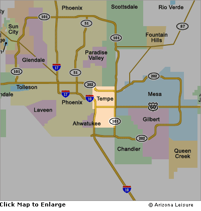
Tempe is centrally located in the Greater Phoenix metropolitan area, immediately east of Phoenix and near Scottsdale, Mesa and Chandler. The Tempe area map below shows the city's position within the Valley of the Sun and its convenient access to Arizona State University, Tempe Town Lake, Downtown Tempe, Phoenix Sky Harbor International Airport and surrounding East Valley communities.
- Tempe Area Map
- Interactive Tempe Map
- Nearby Cities
- Major Roads & Airport Access
- Places Near Tempe
- FAQ
Tempe Arizona Area Map
Interactive Tempe Arizona Map
Use the interactive map to explore Tempe streets, neighborhoods, nearby cities and destinations throughout the Greater Phoenix area. Zoom in for local streets and attractions or zoom out to see Tempe's location within the Valley of the Sun.
Cities Near Tempe Arizona
Tempe's central location places it close to several of the largest communities in the Phoenix metropolitan area. Phoenix lies immediately west of Tempe, Scottsdale is to the north and northwest, Mesa is directly east, and Chandler is south and southeast of the city.
- Phoenix — immediately west of Tempe
- Scottsdale — north and northwest of Tempe
- Mesa — directly east of Tempe
- Chandler — south and southeast of Tempe
Major Roads & Airport Access
Tempe is served by several major Phoenix-area highways, including Loop 202, Loop 101 and US 60. These routes provide convenient connections between Tempe, Phoenix, Scottsdale, Mesa, Chandler and other communities throughout the metropolitan area.
Phoenix Sky Harbor International Airport is located just west of Tempe, making the city a convenient destination for air travelers visiting Arizona State University, Downtown Tempe, Tempe Town Lake and the surrounding East Valley.
Popular Places Near The Tempe Map Area
Many of Tempe's best-known destinations are concentrated near the city's central and northern areas, making it easy to combine several attractions during one visit.
- Downtown Tempe and Arizona State University
- Mill Avenue District
- Tempe Town Lake
- Tempe Beach Park
- Phoenix Sky Harbor International Airport
- Nearby Phoenix, Scottsdale, Mesa and Chandler attractions
Tempe Arizona Map FAQ
Where is Tempe Arizona located?
Tempe is located in the Greater Phoenix metropolitan area in central Arizona. It borders Phoenix and is close to Scottsdale, Mesa and Chandler.
What cities are closest to Tempe?
Phoenix, Scottsdale, Mesa and Chandler are among the major cities closest to Tempe. Tempe's central Valley location makes all four convenient to reach by major roads.
What major highways serve Tempe?
Major highways serving the Tempe area include Loop 202, Loop 101 and US 60, providing connections throughout Greater Phoenix and the East Valley.
Is Tempe close to Phoenix Sky Harbor International Airport?
Yes. Phoenix Sky Harbor International Airport is immediately west of Tempe and provides convenient access to Downtown Tempe, Arizona State University and other local destinations.
Where is Arizona State University in Tempe?
Arizona State University's main Tempe campus is located near Downtown Tempe, Mill Avenue and Tempe Town Lake in the central part of the city.
Where is Tempe Town Lake?
Tempe Town Lake is located along the Salt River near Downtown Tempe and Arizona State University. It is one of the city's best-known recreation and event areas.
Can I use Tempe as a base for exploring Greater Phoenix?
Yes. Tempe's central location and freeway access make it convenient for visiting Phoenix, Scottsdale, Mesa, Chandler and other destinations throughout the metropolitan area.
Related Tempe Interest
Tempe Arizona
Tempe Map
4th Of July - Tempe
Holiday Fantasy Of Lights
Mill Avenue District
Tempe Beach
Tempe Casinos
Tempe Arizona Pictures
Metro Phoenix















