

Scottsdale Arizona Area Map & Nearby Cities
Updated by AZ Leisure Staff Writers on
Use this Scottsdale, Arizona area map to locate major roads, nearby cities, recreation areas and attractions throughout Scottsdale and the eastern Phoenix metropolitan area. Scottsdale stretches from Old Town north through extensive Sonoran Desert communities, making a map especially useful for planning drives between resorts, golf courses, hiking areas, shopping districts and neighboring destinations such as Phoenix, Tempe, Mesa, Paradise Valley and Fountain Hills.
- Scottsdale Map Overview
- Major Roads & Routes
- Interactive Map
- Things To Do Nearby
- Nearby Cities
- Getting Around Scottsdale
- Best Time To Visit
- Map & Travel Tips
- FAQ
Scottsdale Arizona Area Map Overview
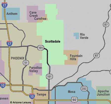
The Scottsdale AZ area map provides a clear overview of this centrally located city within the greater Phoenix metropolitan region, commonly known as the Valley of the Sun. Positioned just east of Phoenix and north of Tempe, Scottsdale is easily accessible via major highways including Loop 101 (Pima Freeway) and Loop 202, making it a convenient starting point for exploring surrounding cities such as Mesa, Paradise Valley, and Fountain Hills. The map highlights Scottsdale’s layout from Old Town and downtown districts to the northern desert foothills, along with nearby parks, golf courses, and access routes to popular attractions throughout the East Valley and central Arizona.
Major Roads & Routes Around Scottsdale
- Loop 101 - Pima Freeway: A major north-south route through Scottsdale connecting with other parts of the Phoenix metropolitan area.
- Loop 202: Provides regional connections through the East Valley and access toward Tempe, Mesa and surrounding communities.
- Scottsdale Road: One of the city's major north-south surface streets connecting Old Town with areas farther north.
- Indian School Road: An important east-west route through central Scottsdale and nearby Phoenix.
- Shea Boulevard: A major east-west corridor through central and North Scottsdale.
- State Route 87: Provides access northeast toward Fountain Hills, the Tonto National Forest and Payson.
Interactive Scottsdale Arizona Map
Things To Do In & Around Scottsdale

Scottsdale's location makes it convenient to combine city attractions with Sonoran Desert recreation. Visitors can hike at Camelback Mountain or the McDowell Sonoran Preserve, explore Old Town Scottsdale, visit nearby Phoenix and Tempe, or travel to the Salt River and Saguaro Lake for outdoor recreation. Other day-trip possibilities include the Superstition Mountains and Tonto National Forest. See our Scottsdale vacation guide and things to do for additional attractions and trip-planning ideas.
Cities & Communities Near Scottsdale
Scottsdale is centrally located within the Phoenix metropolitan area, making it easy to access a wide range of nearby cities and attractions. Each surrounding area offers its own unique mix of activities, dining, and outdoor recreation.
- Phoenix: Borders Scottsdale to the west and offers downtown attractions, museums, professional sports, dining and entertainment.
- Tempe: South of Scottsdale and home to Arizona State University, Tempe Town Lake and the Mill Avenue district.
- Mesa: Southeast of Scottsdale with parks, golf, cultural attractions and access to East Valley recreation.
- Paradise Valley: A smaller community between Scottsdale and Phoenix known for resorts, luxury homes and mountain scenery.
- Fountain Hills: East of Scottsdale and known for its landmark fountain, desert scenery and nearby hiking.
Getting Around Scottsdale
Scottsdale covers a long north-south area, so travel times can vary considerably depending on where you stay and which attractions you plan to visit. Old Town and central Scottsdale contain a concentration of restaurants, galleries, shopping and entertainment, while many resorts, golf courses and desert recreation areas are farther north. A vehicle is useful for reaching attractions outside central Scottsdale, particularly hiking areas, neighboring cities, lakes and other destinations throughout the Valley of the Sun.
Best Time To Visit Scottsdale, Arizona
- Fall (October – November): One of the best times to visit, with warm days and comfortable evenings ideal for outdoor activities.
- Winter (December – February): Peak tourist season with mild temperatures, perfect for golf, hiking, and events.
- Spring (March – April): Popular for spring training baseball, festivals, and excellent weather.
- Summer (May – September): Hot temperatures but fewer crowds and lower hotel rates, with early morning and evening activities recommended.
Scottsdale Map & Travel Planning Tips
- Check distances before leaving: Scottsdale extends a considerable distance from south to north, so locations that share a Scottsdale address may still be far apart.
- Allow extra time during rush periods: Traffic conditions can affect travel times throughout the Phoenix metropolitan area.
- Know your Scottsdale area: Old Town, central Scottsdale and North Scottsdale offer different attractions and lodging environments.
- Use Loop 101 for regional travel: The freeway is one of the primary routes for reaching many parts of Scottsdale and neighboring communities.
- Plan desert trips carefully: Lakes, trailheads and mountain recreation areas can require considerably more driving than attractions within Scottsdale.
- Carry water: Keep drinking water in your vehicle when traveling to desert recreation areas, particularly during warmer months.
- Check road conditions: Construction, weather and special events can temporarily affect routes and travel times.
- Use the interactive map: Confirm current routing and traffic conditions before driving to attractions outside central Scottsdale.
Scottsdale Arizona Map FAQ
Where Is Scottsdale Located In Arizona?
Scottsdale is in the eastern portion of the Phoenix metropolitan area in Maricopa County. It borders Phoenix and is north of Tempe.
What Cities Are Near Scottsdale?
Nearby communities include Phoenix, Tempe, Mesa, Paradise Valley and Fountain Hills, with additional cities throughout the Greater Phoenix area within driving distance.
What Major Freeway Runs Through Scottsdale?
Loop 101, also known as the Pima Freeway, is one of the principal freeways serving Scottsdale and provides connections to other parts of the Phoenix metropolitan area.
Is Scottsdale Close To Phoenix?
Yes. Scottsdale borders Phoenix, although travel time varies significantly depending on the starting point, destination and traffic conditions.
Is Scottsdale Close To Tempe?
Yes. Tempe is directly south of Scottsdale, making attractions such as Tempe Town Lake and the Mill Avenue area relatively convenient from southern and central Scottsdale.
Is Scottsdale Close To Outdoor Recreation?
Yes. Scottsdale provides access to Camelback Mountain, the McDowell Sonoran Preserve and numerous desert trails, while the Salt River, Saguaro Lake and other recreation areas are within driving distance.
Do You Need A Car In Scottsdale?
A car is useful for exploring Scottsdale because the city extends a considerable distance from north to south. Old Town is relatively walkable, but many resorts, golf courses, trailheads and nearby attractions require driving.
What Is The Best Area Of Scottsdale For Visitors?
Old Town is convenient for restaurants, shopping, galleries and nightlife, while North Scottsdale is popular for resorts, golf, desert scenery and access to hiking areas.
What Is The Best Time To Visit Scottsdale?
Fall through spring generally provides the most comfortable weather for outdoor sightseeing, hiking and golf. Summer brings very hot temperatures but may also offer lower lodging rates.
What Can You Visit Near Scottsdale?
Popular nearby destinations include Phoenix, Tempe, Camelback Mountain, the Salt River, Saguaro Lake, Fountain Hills and the Superstition Mountain area.
Related Scottsdale Interest
Scottsdale Arizona
Scottsdale Bed & Breakfasts
Scottsdale Boat Tours
Scottsdale Dude Ranches
Scottsdale Events & Festivals
Metro Phoenix
Phoenix
Scottsdale Map
Tempe
Wickenburg















