


Vermilion Cliffs National Monument Arizona
Reviewed and updated by AZ Leisure Staff Writers on .
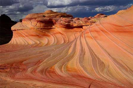 The Wave at North Coyote Buttes. © Mike Koopsen
Vermilion Cliffs National Monument protects approximately 280,000 acres of dramatic desert wilderness in northern Arizona along the Utah border. Managed by the Bureau of Land Management, the monument includes the colorful Vermilion Cliffs, Paria Plateau, Paria Canyon and Coyote Buttes, home to the internationally known sandstone formation called The Wave. Visitors come for hiking, backpacking, photography, wildlife viewing and some of the most striking sandstone scenery on the Colorado Plateau, but the monument's remote terrain requires careful planning and permits are required for several popular areas.
- Landscape & Geology
- Wildlife & California Condors
- Places To See
- The Wave & Hiking Permits
- Planning & Safety
- Getting There
- Map
- FAQ
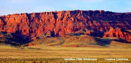
Vermilion Cliffs Landscape & Geology
Vermilion Cliffs National Monument is defined by towering sandstone escarpments, broad plateaus, narrow slot canyons and sweeping desert valleys. Elevations range from approximately 3,100 to 7,100 feet, creating a remarkably varied landscape. Navajo sandstone has been sculpted by wind and water into colorful bands, fins, alcoves, arches and swirling formations, while the monument's remote setting has preserved an exceptional sense of wilderness and solitude.
Wildlife & California Condors
Vermilion Cliffs provides habitat for desert bighorn sheep, pronghorn, mule deer, mountain lions and a variety of desert birds and reptiles. The monument is especially important to the recovery of the endangered California condor. Condors have been released in the Vermilion Cliffs area since 1996, and these enormous birds can sometimes be seen soaring over or roosting along the cliffs.
A designated California Condor Viewing Site near the monument provides interpretive information and opportunities to watch for condors. Binoculars or a spotting scope are helpful because the birds may be seen at considerable distances.
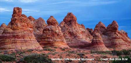
Places To See In Vermilion Cliffs National Monument
- Coyote Buttes North: Home to The Wave, one of the monument's most photographed sandstone formations. A permit is required.
- Coyote Buttes South: A separate permit area featuring colorful sandstone formations, fins and sweeping backcountry scenery.
- Paria Canyon: A spectacular wilderness canyon known for backpacking, colorful canyon walls and long stretches of remote slot-canyon scenery.
- Paria Plateau: A broad elevated landscape of sandstone, desert vegetation and remote backcountry terrain.
- Vermilion Cliffs: The monument's massive namesake escarpment rises dramatically above the surrounding desert landscape.
- White Pocket: A remote sandstone area known for unusually twisted, layered and multicolored rock formations.
Vermilion Cliffs also contains archaeological and cultural resources reflecting thousands of years of human use of the Arizona Strip. Visitors may encounter rock art, historic sites and other cultural resources in remote areas. These sites are protected by federal law and should be viewed without touching, removing artifacts or disturbing archaeological features.
The Wave, Coyote Buttes & Paria Canyon Permits
Permits are required for some of the most popular areas within Vermilion Cliffs National Monument and the adjoining Paria Canyon-Vermilion Cliffs Wilderness. Visitors should determine which permit applies before beginning a hike because permits for one area do not authorize entry into another.
- Coyote Buttes North - The Wave: A day-use permit is required. Permits are limited and distributed through advance and daily lottery systems.
- Coyote Buttes South: A separate day-use permit is required and does not provide access to The Wave.
- Paria Canyon day use: A Paria Canyon day-use permit is required and can currently be obtained at participating trailheads or in advance through Recreation.gov.
- Paria Canyon overnight trips: An advance permit is required, with overnight entry limited by BLM.
Permit procedures, fees and availability can change. Check the BLM Arizona permit information before planning a visit.
Planning & Safety At Vermilion Cliffs
Vermilion Cliffs is remote backcountry with few services and no visitor center within the monument. Roads may be unmarked, deeply sandy, muddy or impassable after storms, and many routes require a high-clearance four-wheel-drive vehicle. Cell service should not be relied upon.
- Carry plenty of water: Desert heat and strenuous hiking can cause dehydration quickly.
- Check the weather: Flash flooding is a serious hazard in Paria Canyon, Buckskin Gulch and other narrow canyons.
- Check road conditions: Rain or snow can make remote dirt roads impassable.
- Carry emergency supplies: Bring extra food, water, fuel and a full-size spare tire.
- Know your route: Many backcountry areas have no developed trails and require navigation skills.
- Protect wilderness resources: Stay on established routes where appropriate and leave archaeological, geological and natural features undisturbed.
Getting To Vermilion Cliffs National Monument
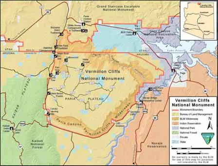
Vermilion Cliffs National Monument lies in northern Arizona between Kaibab National Forest to the west and Glen Canyon National Recreation Area to the east. Major approaches are from U.S. Highway 89 and U.S. Highway 89A, but the roads leading into much of the monument are unpaved and conditions can vary dramatically with weather.
From Flagstaff: Travel north on U.S. Highway 89 toward Page and the Arizona-Utah border. Access routes vary depending on whether your destination is Paria Canyon, Coyote Buttes, White Pocket, the Vermilion Cliffs or another backcountry area.
From Kanab, Utah: U.S. Highway 89 provides access toward the northern portions of the monument and Paria Canyon area, while U.S. Highway 89A provides access toward House Rock Valley and the western side of the monument.
There are no paved roads within the monument itself. Check current BLM road and weather conditions before leaving the highway.
Vermilion Cliffs National Monument Map
More Information
Vermilion Cliffs National Monument - Bureau of Land Management
Arizona Strip Field Office
4001 East Aviator Drive
St. George, Utah 84790
435-688-3200
Vermilion Cliffs National Monument FAQ
Where is Vermilion Cliffs National Monument?
Vermilion Cliffs National Monument is located in northern Arizona along the Utah border, between Kaibab National Forest and Glen Canyon National Recreation Area.
Is The Wave inside Vermilion Cliffs National Monument?
Yes. The Wave is located in Coyote Buttes North within the Paria Canyon-Vermilion Cliffs Wilderness and is one of the best-known destinations associated with Vermilion Cliffs National Monument.
Do you need a permit to hike to The Wave?
Yes. A permit is required to enter Coyote Buttes North and hike to The Wave. Permits are limited and distributed through advance and daily lottery systems.
Do you need a permit for Paria Canyon?
Yes. Paria Canyon requires permits for day use and overnight trips. Overnight permits must be obtained in advance and are subject to visitor limits.
How large is Vermilion Cliffs National Monument?
The Bureau of Land Management currently describes Vermilion Cliffs National Monument as approximately 280,000 acres of public land in northern Arizona.
Can you drive through Vermilion Cliffs National Monument?
There are numerous backcountry roads, but no paved roads within the monument. Many routes are rugged and may require a high-clearance four-wheel-drive vehicle, especially where deep sand or difficult road conditions are present.
Are California condors found at Vermilion Cliffs?
Yes. Vermilion Cliffs is an important California condor recovery area. Condors have been released here since 1996 and may sometimes be seen soaring above or roosting on the cliffs.
What are the main attractions at Vermilion Cliffs?
Popular destinations include The Wave at Coyote Buttes North, Coyote Buttes South, Paria Canyon, the Paria Plateau, White Pocket and the towering Vermilion Cliffs themselves.















