

Petrified Forest National Park Map & Directions
Updated by AZ Leisure Staff Writers on
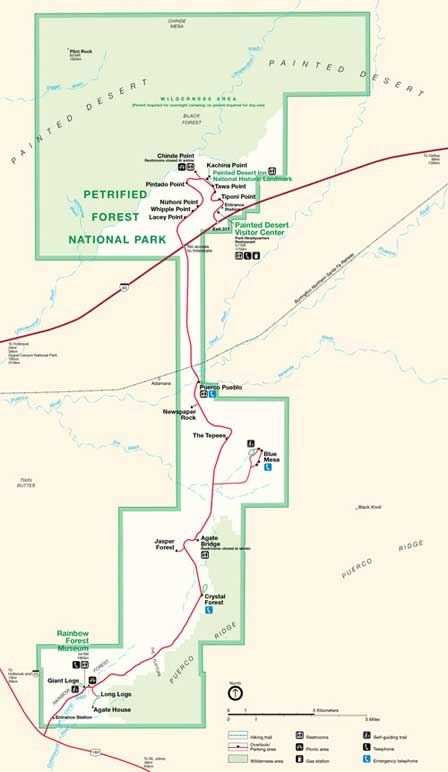
Petrified Forest National Park stretches between Interstate 40 and U.S. Highway 180 in northeastern Arizona, with a north entrance near the Painted Desert and a south entrance near Rainbow Forest. A 28-mile park road connects the two entrances, passing overlooks, trails, petrified wood areas, archaeological sites, historic Route 66 and visitor facilities along the way.
This map and directions guide explains the best approach from Flagstaff, Phoenix, Holbrook and Interstate 40, along with entrance locations, GPS coordinates, scenic-drive information and current visitor-planning tips. Because the park has two separate entrances, entering at one end and exiting at the other is often the most efficient way to visit.
- Petrified Forest Quick Facts
- Park Map
- North & South Entrances
- Eastbound I-40 Directions
- Westbound I-40 Directions
- Directions From Phoenix
- Scenic Drive & Stops
- Visitor Centers
- Historic Route 66
- Best Time To Visit
- Visitor Tips
- FAQ
Petrified Forest National Park Quick Facts
- Location: Northeastern Arizona along Interstate 40 and U.S. Highway 180
- North entrance: Interstate 40 Exit 311
- South entrance: U.S. Highway 180 southeast of Holbrook
- Park road: Approximately 28 miles between entrances
- Nearest town: Holbrook, Arizona
- Major areas: Painted Desert, Blue Mesa, Rainbow Forest and petrified wood deposits
- Historic feature: Original Route 66 alignment passes through the park
- Public transportation: None to or within the park
- RV access: Main park road accommodates RVs and trailers
- Open season: Park operates year-round except designated holiday closures
Petrified Forest National Park Entrances
Petrified Forest National Park has two vehicle entrances. The north entrance is directly off Interstate 40 at Exit 311 beside the Painted Desert Community Complex. The south entrance is reached from U.S. Highway 180 southeast of Holbrook near Rainbow Forest Museum.
The park road connects the two entrances, making it convenient to enter at one end and exit at the other rather than retracing the entire route. Which entrance is best depends primarily on your direction of travel.
Petrified Forest National Park Map
Click the map for an enlarged PDF view showing the park road, entrances, visitor areas, overlooks, trails and major attractions.
Eastbound Interstate 40 Directions
Travelers heading east on Interstate 40 should take Exit 285 into Holbrook, then follow U.S. Highway 180 south for approximately 19 miles to the south entrance of Petrified Forest National Park. From there, drive approximately 28 miles north through Rainbow Forest, Blue Mesa and the Painted Desert before returning to Interstate 40 at Exit 311.
Westbound Interstate 40 Directions
Travelers heading west on Interstate 40 should take Exit 311 directly into the north entrance of Petrified Forest National Park. Drive approximately 28 miles south through the Painted Desert and Petrified Forest, then exit onto U.S. Highway 180. Follow Highway 180 north approximately 19 miles to Holbrook and Interstate 40.
Directions From Phoenix To Petrified Forest
From north and west Phoenix: Take Interstate 17 north to Flagstaff, then Interstate 40 east toward Holbrook and Petrified Forest National Park. The National Park Service lists this route at approximately 259 miles.
From east Phoenix: Take Arizona Highway 87 north through Payson, Highway 260 east through the Mogollon Rim and Heber, Highway 377 north to Holbrook, then Highway 180 south to the park. NPS lists this route at approximately 215 miles.
The eastern route is shorter from many East Valley locations and provides a scenic drive through central and northeastern Arizona, while the Interstate route is often more straightforward from western and northern Phoenix.
Petrified Forest Scenic Drive & Major Stops
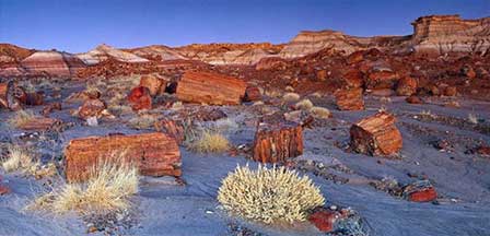
The approximately 28-mile park road connects the Painted Desert at the north end with Rainbow Forest at the south end. Visitors can stop at scenic overlooks, short trails, archaeological sites, historic buildings and major petrified wood areas without leaving the main road system.
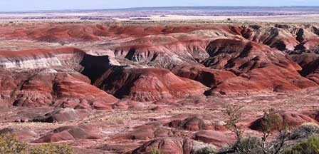
- Painted Desert: Colorful badlands and broad overlooks near the north entrance.
- Painted Desert Inn: National Historic Landmark with exhibits and sweeping views.
- Historic Route 66: Old road alignment marked by telephone poles and a vintage Studebaker.
- Puerco Pueblo: Ancestral Puebloan archaeological site with petroglyphs.
- Newspaper Rock: Overlook with hundreds of petroglyphs.
- Blue Mesa: Colorful blue, purple and gray badlands with a loop drive and hiking trail.
- Agate Bridge: A petrified log spanning a natural wash.
- Jasper Forest: Extensive views of petrified wood scattered across the landscape.
- Rainbow Forest: Major petrified wood area near the south entrance and museum.
Petrified Forest GPS Coordinates
Painted Desert Community Complex / North Entrance
Latitude: 35.06543746738773
Longitude: -109.78153824806213
Rainbow Forest Museum / South Entrance
Latitude: 34.81517743163217
Longitude: -109.86576497554779
Painted Desert Inn National Historic Landmark
Latitude: 35.08343319608185
Longitude: -109.78861391544342
The National Park Service recommends using the clearly marked park entrances rather than relying exclusively on GPS or third-party mapping apps, which can occasionally route visitors toward unsuitable backroads.
Petrified Forest Visitor Centers
Petrified Forest National Park has visitor facilities at both ends of the park, but current operations should be checked before traveling.
Painted Desert Community Complex: Located at Interstate 40 Exit 311 near the north entrance. The Painted Desert Visitor Center building is currently closed for construction, but the surrounding complex remains open with restrooms, gift shop, gas station, picnic facilities, restaurant services and trail access.
Painted Desert Inn National Historic Landmark: Located approximately two miles from the north entrance at Kachina Point. It currently serves as the north visitor center, with information, bookstore, exhibits, gallery space and access to the Painted Desert Rim Trail.
Rainbow Forest Museum: Located near the south entrance. The museum provides visitor information, paleontology exhibits, bookstore, backcountry permits, restrooms and access to Giant Logs, Long Logs and Agate House trails.
Historic Route 66 At Petrified Forest
Petrified Forest National Park is the only national park containing a preserved section of historic Route 66. The former highway alignment crossed the northern part of the park before Interstate 40 replaced it.
Visitors can see the old roadbed marked by a line of weathered telephone poles and a 1932 Studebaker near the park road. The stop adds an important Route 66 history element to a Petrified Forest scenic drive.
Best Time To Visit Petrified Forest National Park
- Spring: Mild temperatures and longer daylight make spring excellent for scenic driving, hiking and photography.
- Summer: Daytime highs can reach the 90s. July and August also bring monsoon thunderstorms, lightning, short heavy rains and occasional hail.
- Fall: Cooler temperatures and generally comfortable conditions make fall another excellent season for hiking and sightseeing.
- Winter: Cold nights, occasional snow and crisp clear air can create dramatic Painted Desert scenery with lighter crowds.
Petrified Forest Visitor Tips
- Plan to enter at one end of the park and exit at the other whenever practical.
- Check current park hours before arriving because entrance gates close at the end of the operating day.
- Allow at least two to three hours for a basic scenic drive, and longer if you plan to hike or explore museums.
- Carry drinking water, especially during warm spring and summer weather.
- Watch for summer thunderstorms and lightning, particularly during July and August.
- Do not remove petrified wood, fossils, rocks, archaeological artifacts or other natural or cultural resources.
- Large RVs can use the main park road, but some smaller overlook parking areas are difficult for long rigs.
- Download maps or directions before traveling because cell service can be inconsistent.
- Use official park entrances rather than following questionable GPS routes onto remote backroads.
- Check current visitor-center status before relying on a specific building for services.
Nearby Petrified Forest Attractions & Towns
- Painted Desert — Colorful badlands extending through the northern part of the park.
- Petrified Forest National Park Guide — History, geology, trails and visitor attractions.
- Magic In The Painted Desert — Scenic travel feature about the region.
- Ancient People Of Petrified Forest — Archaeology and early cultures of the park.
- Petrified Forest & Painted Desert Photos — Scenic image gallery.
- Holbrook Arizona — Closest major gateway community, if this page exists on your site.
Petrified Forest National Park FAQ
Where Is Petrified Forest National Park?
Petrified Forest National Park is located in northeastern Arizona between Interstate 40 and U.S. Highway 180, east of Holbrook.
Which Exit Do You Take For Petrified Forest National Park?
The north entrance is directly off Interstate 40 at Exit 311. The south entrance is reached from U.S. Highway 180 southeast of Holbrook.
How Long Is The Drive Through Petrified Forest National Park?
The main park road is approximately 28 miles long between the north and south entrances. Actual visit time depends on how many overlooks, trails, museums and historic sites you stop to explore.
Can You Drive Through Petrified Forest National Park?
Yes. A paved scenic road connects the Painted Desert at the north end with Rainbow Forest at the south end, allowing visitors to enter at one entrance and exit at the other.
Can RVs Drive Through Petrified Forest National Park?
Yes. The main park road accommodates RVs and trailers, although some smaller overlook parking areas are less suitable for large rigs.
Is Petrified Forest National Park On Route 66?
Yes. Petrified Forest National Park contains a preserved section of historic Route 66 and is the only National Park System unit with a section of the famous highway.
Is The Painted Desert Visitor Center Open?
The Painted Desert Visitor Center building is currently closed for construction, but the surrounding community complex remains open with visitor services. The Painted Desert Inn currently serves as the north visitor center.
What Is The Closest Town To Petrified Forest National Park?
Holbrook, Arizona is the principal nearby gateway community and provides access to the south entrance by way of U.S. Highway 180.
What Is The Best Time To Visit Petrified Forest National Park?
Spring and fall generally provide the most comfortable temperatures. Summer can be hot with monsoon thunderstorms, while winter brings cold temperatures and occasional snow.
Can You Take Petrified Wood From Petrified Forest National Park?
No. Removing petrified wood, fossils, rocks, archaeological materials or other natural and cultural resources from the national park is prohibited.
Related Painted Desert Interest
Painted Desert
Magic In The Painted Desert
Ancient People Petrified Forest
Petrified Forest Painted Desert Photos
Petrified Forest















