

Schultz Pass Road Scenic Drive Near Flagstaff, Arizona
Updated by AZ Leisure Staff Writers on
Schultz Pass Road is a scenic forest drive just north of Flagstaff, Arizona, offering close-up views of the San Francisco Peaks, ponderosa pine forests, wildlife habitat and access to popular hiking and mountain-biking trails. Forest Road 420 crosses Schultz Pass between the U.S. 180 and U.S. 89 sides of Flagstaff, making it an easy escape into Coconino National Forest when road and weather conditions permit.
- Schultz Pass Overview
- Scenic Drive Highlights
- Directions & Route
- Road Conditions & Best Time
- Hiking & Biking Trails
- Wildlife & Scenery
- Schultz Pass Map
- FAQ
Schultz Pass Road Overview
- Location: Coconino National Forest just north of Flagstaff, Arizona
- Forest Road: FR 420, also known as Schultz Pass Road
- Scenery: San Francisco Peaks, ponderosa pine forest, meadows and mountain views
- Activities: Scenic driving, hiking, mountain biking, horseback riding, picnicking and wildlife viewing
- Road Surface: Portions of Schultz Pass Road are unpaved forest road
- Season: Access varies with snow, wet weather, fire restrictions and temporary Forest Service closures
Schultz Pass Scenic Drive Highlights
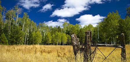
Schultz Pass Road provides quick access to the forests beneath the San Francisco Peaks and is popular with motorists, hikers, mountain bikers and horseback riders. Along the route, travelers can enjoy mountain views, shaded ponderosa pine forest, seasonal wildflowers, fall color and numerous trail connections. Picnic areas and roadside pullouts provide opportunities to stop and enjoy the surrounding Coconino National Forest.
Wildlife & Scenic Views Along Schultz Pass
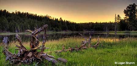
Wildlife commonly associated with the forests around Schultz Pass includes elk, mule deer, foxes and numerous bird species. Sightings are never guaranteed, but early morning and evening can provide good opportunities for wildlife viewing and photography. Visitors should observe animals from a safe distance and avoid approaching or feeding wildlife.
Schultz Pass Road Directions & Route
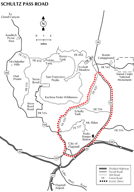
From Flagstaff, travel north on U.S. 180 and turn northeast onto Schultz Pass Road, Forest Road 420. The route climbs through Coconino National Forest and crosses Schultz Pass before continuing toward the U.S. 89 side of Flagstaff. Travelers can return to Flagstaff by highway to complete a scenic loop. Because forest-road access and conditions can change, check current Coconino National Forest road information before beginning the drive.
Schultz Pass Road Conditions & Best Time To Visit
Schultz Pass Road is generally most accessible during the warmer months, but opening and closing dates vary with snowpack, wet weather, fire activity and other Forest Service restrictions. Higher-elevation forest roads around Flagstaff may remain closed after winter storms or become temporarily inaccessible during poor road conditions.
U.S. 180 and U.S. 89 are paved highways, while portions of Schultz Pass Road are unpaved. Surface conditions can change because of storms, runoff, washboarding and seasonal maintenance. Check current Coconino National Forest road status before driving and avoid unpaved forest roads when conditions are muddy or unsafe.
Hiking & Mountain Biking Near Schultz Pass Road
Schultz Pass Road provides access to a network of hiking, mountain-biking and horseback-riding routes in the Coconino National Forest. Popular trail connections in the area include Sunset Trail and Weatherford Trail, along with additional routes around Schultz Creek, Mount Elden and the San Francisco Peaks. Trail conditions and permitted uses vary, so check current Forest Service information and posted trail signs before starting a trip.
Side roads branching from Schultz Pass Road can be rougher than the main route. Do not assume that every forest road is suitable for a passenger car, and avoid driving roads that are muddy, snow-covered or posted closed.
Before Driving Schultz Pass Road
- Check road status: Forest roads may close because of snow, wet conditions, wildfire activity or maintenance.
- Check the weather: Mountain conditions near Flagstaff can change quickly.
- Avoid muddy roads: Driving wet forest roads can damage the road surface and may leave vehicles stranded.
- Carry water: Bring drinking water even for short drives or hikes.
- Download maps: Mobile service may be inconsistent in forested and mountain areas.
- Respect trail users: Schultz Pass is popular with hikers, cyclists and horseback riders as well as motorists.
For More Information
- Flagstaff Ranger Station
- Coconino National Forest
- 5075 N. Highway 89
- Flagstaff, Arizona 86001
- (928) 526-0866
Nearest Lodging & Accommodations
Flagstaff offers the nearest major selection of hotels, motels, bed and breakfast inns, RV parks and other vacation accommodations for visitors exploring Schultz Pass and the San Francisco Peaks area.
Schultz Pass Road Map
Schultz Pass Road FAQ
Where Is Schultz Pass Road?
Schultz Pass Road is located just north of Flagstaff, Arizona, in the Coconino National Forest between the San Francisco Peaks and Mount Elden area.
What Forest Road Is Schultz Pass Road?
Schultz Pass Road is designated Forest Road 420, commonly abbreviated FR 420.
Is Schultz Pass Road Paved?
Portions of the approach are paved, but Schultz Pass Road includes unpaved forest-road sections. Surface conditions can vary with weather, runoff and maintenance.
Can Passenger Cars Drive Schultz Pass Road?
Road suitability depends on current conditions and the vehicle. The main road may be manageable for many passenger vehicles when dry and maintained, but rough, muddy, snowy or damaged conditions can make travel more difficult. Check current Forest Service road information before driving.
When Is The Best Time To Drive Schultz Pass Road?
The warmer months generally provide the best access, but there are no guaranteed seasonal opening dates. Snow, wet weather, fire activity and temporary Forest Service closures can affect access.
Is Schultz Pass Road Open In Winter?
Winter access may be limited or closed because of snow and road conditions. Drivers should verify current Coconino National Forest road status before making the trip.
How Long Does The Schultz Pass Scenic Drive Take?
The drive itself can be completed relatively quickly when the road is open, but visitors should allow additional time for scenic stops, hiking, photography and trail access.
Are There Hiking Trails Along Schultz Pass Road?
Yes. Schultz Pass Road provides access to several hiking and mountain-biking routes, including connections to Sunset Trail, Weatherford Trail and other trails in the surrounding Coconino National Forest.
Can You Mountain Bike Schultz Pass Road?
Yes. Schultz Pass Road and the surrounding trail network are popular with mountain bikers. Riders should follow current trail-use regulations and yield appropriately to other trail users.
What Wildlife Can You See Near Schultz Pass?
The surrounding forest provides habitat for animals including elk, mule deer, foxes and numerous bird species. Wildlife sightings vary by season, time of day and conditions.















