
Vermilion Cliffs National Monument Photos
Updated by AZ Leisure Staff Writers on
 The Wave at Coyote Buttes North. © Mike Koopsen
Vermilion Cliffs National Monument protects approximately 280,000 acres of spectacular desert wilderness in northern Arizona along the Utah border. Elevations range from about 3,100 to 7,100 feet, creating an extraordinary landscape of colorful sandstone cliffs, sweeping plateaus, slot canyons and sculpted rock formations. This photo gallery highlights some of the monument's most recognizable scenery, including The Wave, White Pocket, Coyote Buttes, Paria Canyon and the Vermilion Cliffs themselves.
The photographs below are courtesy of their respective photographers and copyright owners and showcase the remarkable variety of scenery found throughout the region, including The Wave, White Pocket, Coyote Buttes, Buckskin Gulch, Paria Canyon and the Vermilion Cliffs. From narrow sandstone passages to broad desert panoramas, the gallery illustrates why this remote part of the Colorado Plateau is especially popular with hikers and landscape photographers.
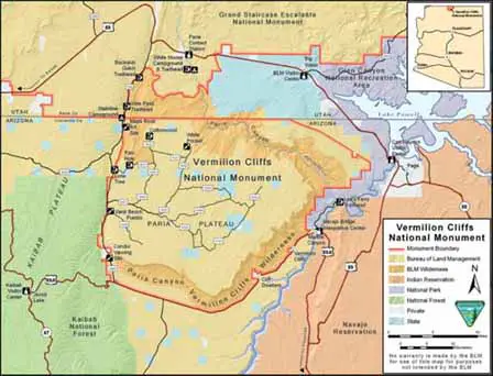
Use the map below for a general overview of the monument and surrounding recreation areas. Because many destinations are reached by remote backcountry roads and some require permits, consult current Bureau of Land Management maps and visitor information before traveling.
Vermilion Cliffs National Monument Map
Vermilion Cliffs National Monument Photo Gallery
 Navajo Bridge Crossing To Reach The Monument. © GlynLowe.com
 Vermilion Cliffs - The Wave. © Mike Koopsen
 Vermilion Cliffs - White Pocket. © Mike Koopsen
 Vermilion Cliffs - The Wave. © Mike Koopsen
 Vermilion Cliffs - Cottonwood Cove at Sunset. © John Fowler
 Vermilion Cliffs - Dali Rock at Coyote Buttes. © John Fowler
 Vermilion Cliffs - Wilderness. © John Fowler
 Vermilion Cliffs - White Pocket. © John Fowler
 Vermilion Cliffs - White Pocket. © John Fowler
 Vermilion Cliffs - Cottonwood Cove at South Coyote Buttes. © John Fowler
 Vermilion Cliffs - Paw Hole at South Coyote Buttes. © John Fowler
 Vermilion Cliffs - National Monument. Credit: BLM
 Vermilion Cliffs - National Monument. Credit: BLM
 Vermilion Cliffs - National Monument. Credit: BLM
 Vermilion Cliffs - National Monument. Credit: BLM
 Vermilion Cliffs - Wilderness. Credit: Bob Wick BLM
 Vermilion Cliffs - Wilderness. Credit: Bob Wick BLM
 Vermilion Cliffs - Buckskin Gulch. © Chris Morris
 Vermilion Cliffs - Buckskin Gulch. © Mark Byzewski
 Vermilion Cliffs - Buckskin Gulch. © Philms
 Vermilion Cliffs - Buckskin Gulch Trail. © Dave P
 Vermilion Cliffs - Paria Canyon. © Rick McCharles
 Vermilion Cliffs - Paria Canyon. © Rick McCharles
 Vermilion Cliffs - Paria Canyon. © Rick McCharles
Featured Vermilion Cliffs Photo Locations
The gallery includes several of the best-known landscapes associated with Vermilion Cliffs National Monument and the surrounding Paria Canyon-Vermilion Cliffs Wilderness.
- The Wave: The famous cross-bedded sandstone formation in the Coyote Buttes North permit area.
- White Pocket: A remote area of swirling orange, yellow and white slickrock on the Paria Plateau.
- Coyote Buttes South: Colorful sandstone domes, fins and formations in a separate permit area south of The Wave.
- Buckskin Gulch: One of the world's longest continuous slot canyons, extending through the northern portion of the Paria Canyon-Vermilion Cliffs Wilderness.
- Paria Canyon: A wilderness canyon known for high sandstone walls, desert varnish, arches and multi-day backpacking routes.
- Vermilion Cliffs: The towering namesake escarpment that dominates the western portion of the monument.
Permits & Access To Photo Locations
Several locations shown in this gallery require permits or special backcountry preparation. A permit is required to visit Coyote Buttes North, including The Wave, and a separate permit is required for Coyote Buttes South. Paria Canyon also requires permits for day use and overnight trips. White Pocket currently does not require an entrance permit, but access involves deep sand and rugged backcountry roads where a high-clearance four-wheel-drive vehicle is strongly recommended.
Permit procedures, road conditions and visitor requirements can change. Check current Bureau of Land Management Vermilion Cliffs information before visiting any of these locations.
Vermilion Cliffs Photography Tips
- Protect your camera from sand: Fine desert sand can affect lenses, tripods and camera mechanisms, especially during windy conditions.
- Use changing light: Early and late daylight can emphasize the texture, contours and colors of sandstone formations.
- Carry extra water: Photography often keeps visitors outdoors longer than expected in an extremely dry environment.
- Know your route: The Wave, Coyote Buttes and White Pocket are remote areas where navigation and road conditions can be challenging.
- Watch the weather: Flash floods can develop in slot canyons including Buckskin Gulch and Paria Canyon.
- Protect fragile formations: Avoid climbing on delicate sandstone features or disturbing natural and archaeological resources while choosing photo locations.
Vermilion Cliffs Photo Gallery FAQ
Where is Vermilion Cliffs National Monument?
Vermilion Cliffs National Monument is located in northern Arizona along the Utah border. The approximately 280,000-acre monument includes the Vermilion Cliffs, Paria Plateau, Coyote Buttes and Paria Canyon.
Where is The Wave located?
The Wave is located in the Coyote Buttes North permit area of the Paria Canyon-Vermilion Cliffs Wilderness in northern Arizona.
Do you need a permit to photograph The Wave?
Yes. Everyone entering Coyote Buttes North to visit or photograph The Wave must have a valid permit.
Is White Pocket inside Vermilion Cliffs National Monument?
Yes. White Pocket is located on the Paria Plateau within Vermilion Cliffs National Monument and is known for its colorful, unusually shaped sandstone formations.
Do you need a permit to visit White Pocket?
White Pocket currently does not require an entrance permit, but access is remote and includes deep sand and rugged backcountry roads where a high-clearance four-wheel-drive vehicle is recommended.
Is Coyote Buttes South the same as The Wave?
No. The Wave is in Coyote Buttes North. Coyote Buttes South is a separate permit area with different sandstone formations and its own access requirements.
Where is Buckskin Gulch?
Buckskin Gulch extends through the northern portion of the Paria Canyon-Vermilion Cliffs Wilderness and is known for approximately 16 miles of continuous slot-canyon scenery.
What are the best-known places to photograph at Vermilion Cliffs?
Popular photography locations include The Wave, White Pocket, Coyote Buttes, Buckskin Gulch, Paria Canyon and the towering Vermilion Cliffs escarpment.
Information Relating To Vermilion Cliffs
Vermilion Cliffs National Monument
Vermilion Cliffs Map and Directions
Vermilion Cliffs Videos
Guided Hiking and Photography Tours
Dreamland Tours and Guides
Related Lake Powell-Page Interest
Lake Powell-Page
Map & Directions Vermilion Cliffs
Vermilion Cliffs Wilderness Videos
Vermilion Cliffs National Monument