


Vermilion Cliffs National Monument Map & Directions
Updated by AZ Leisure Staff Writers on
Vermilion Cliffs National Monument is a remote 280,000-acre Bureau of Land Management recreation area in northern Arizona near the Utah border. The monument includes the Paria Plateau, Vermilion Cliffs, Coyote Buttes, White Pocket and portions of the Paria Canyon-Vermilion Cliffs Wilderness, making it one of the Southwest's premier destinations for hiking, photography and backcountry exploration.
Reaching Vermilion Cliffs requires more planning than visiting a typical national park. U.S. Highway 89 and U.S. Highway 89A provide the main paved approaches, but there are no paved roads inside the monument. House Rock Valley Road and other backcountry routes may become impassable when wet, while destinations such as White Pocket require a high-clearance four-wheel-drive vehicle and experience driving in deep sand.
- Vermilion Cliffs Quick Facts
- Location Map
- Main Access Routes
- Directions From Page
- Directions From Kanab
- White Pocket Access
- The Wave Access & Permits
- Road & Vehicle Conditions
- GPS Coordinates
- Visitor Tips
- FAQ
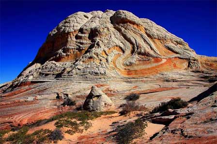 White Pocket. © Mike Koopsen
Vermilion Cliffs National Monument Quick Facts
- Location: Northern Arizona along the Utah border
- Size: Approximately 280,000 acres
- Established: November 9, 2000
- Managing agency: Bureau of Land Management
- Main paved approaches: U.S. Highway 89 and U.S. Highway 89A
- Roads inside monument: Unpaved
- Major destinations: White Pocket, Coyote Buttes, The Wave, Paria Canyon and Vermilion Cliffs
- Vehicle needs: Vary by destination; many backcountry roads require high-clearance four-wheel drive
- Permits: Required for The Wave, Coyote Buttes South and overnight Paria Canyon trips
- Visitor center: No developed visitor center inside the monument
Major Areas Within Vermilion Cliffs
- White Pocket: Remote swirling sandstone formations reached by difficult sandy four-wheel-drive roads.
- Coyote Buttes North: Permit-controlled wilderness containing The Wave.
- Coyote Buttes South: Remote sandstone formations requiring a separate permit and high-clearance four-wheel-drive access.
- Paria Canyon: Long wilderness canyon popular for day hiking and multi-day backpacking.
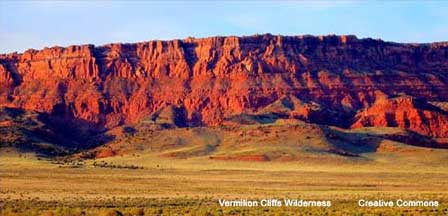
- Vermilion Cliffs: Massive colorful escarpments rising above Highway 89A and Marble Canyon.
- California Condor Viewing Area: Opportunities to see endangered California condors near the Vermilion Cliffs.
Best Time To Visit Vermilion Cliffs National Monument
- Spring: Mild daytime temperatures make spring excellent for hiking, photography and backcountry travel, although storms can make dirt roads impassable.
- Summer: Extreme heat and flash-flood risk can make hiking dangerous. Begin early, carry substantial water and monitor weather closely.
- Fall: Cooler temperatures and generally favorable hiking conditions make fall one of the most popular seasons.
- Winter: Light crowds and dramatic scenery are appealing, but snow, ice, mud and freezing temperatures can restrict backcountry access.
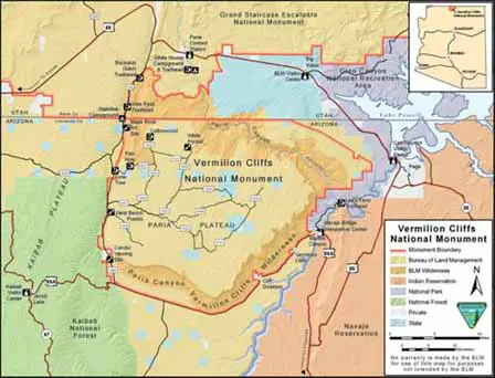
Vermilion Cliffs National Monument lies in northern Arizona immediately south of the Utah state line. The monument borders Kaibab National Forest to the west and Glen Canyon National Recreation Area to the east, while the larger Paria Canyon-Vermilion Cliffs Wilderness and associated recreation areas extend toward southern Utah.
Getting To Vermilion Cliffs National Monument
There is no single entrance road or entrance station for Vermilion Cliffs National Monument. Access depends on the destination. U.S. Highway 89 approaches the northern portion of the monument and Paria Plateau from Page, Arizona and Kanab, Utah, while U.S. Highway 89A provides access to the southern Vermilion Cliffs and Marble Canyon area.
House Rock Valley Road, also designated BLM 1065, is one of the principal unpaved routes into the monument. Although it is considered a maintained dirt road, BLM warns that it can become impassable when wet.
Directions From Page Arizona
From Page, U.S. Highway 89 west provides access toward the Paria Contact Station, House Rock Valley Road and the northern monument backcountry. The Paria Contact Station is approximately 30 miles west of Page on Highway 89.
For the southern Vermilion Cliffs and Marble Canyon area, travel south from Page toward the U.S. 89A junction at Bitter Springs, then continue on Highway 89A toward Navajo Bridge and Marble Canyon.
Directions From Flagstaff Arizona
From Flagstaff, travel north on U.S. Highway 89 toward Page. For Marble Canyon and the southern Vermilion Cliffs, turn onto U.S. Highway 89A at Bitter Springs. Travelers heading toward northern access points such as House Rock Valley Road continue farther north on Highway 89.
Directions From Kanab Utah
From Kanab, travel east on U.S. Highway 89 for access to the Paria Contact Station, House Rock Valley Road and northern Vermilion Cliffs destinations. The Paria Contact Station is approximately 43 miles east of Kanab.
For the southern portion of the monument, travelers can also use U.S. Highway 89A through Fredonia and Jacob Lake toward the Vermilion Cliffs and Marble Canyon.
Directions To White Pocket
White Pocket is one of the most remote destinations within Vermilion Cliffs National Monument. Access begins from House Rock Valley Road, also known as BLM 1065, followed by a network of unmaintained sandy backcountry roads leading onto the Paria Plateau.
BLM requires a high-clearance four-wheel-drive vehicle for the route to White Pocket. Roads include deep sand, slick clay and uneven rock, and conditions change frequently. Vehicles can become stuck even during dry weather, while rain or snow can make sections impassable.
Travelers without four-wheel-drive experience or an appropriately equipped vehicle should strongly consider using a permitted guide rather than attempting the route independently.
The Wave & Coyote Buttes North Access
The Wave is located within Coyote Buttes North in the Paria Canyon-Vermilion Cliffs Wilderness. A permit is required for every visitor, and there are no developed hiking trails or facilities within the permit area.
The suggested route to The Wave is approximately 6.4 miles round trip across rugged wilderness terrain where route-finding skills are necessary. Visitors should not treat the hike as a maintained trail.
Permits are issued through two systems: an Advance Lottery for visitors planning about four months ahead and a Daily Lottery for visitors already within the designated geographic application area. The Daily Lottery uses a location-enabled mobile device and Recreation.gov rather than the former in-person walk-in lottery.
Things To Do Near Vermilion Cliffs National Monument
- Visit White Pocket: Explore colorful sandstone formations and unusual rock patterns deep within Vermilion Cliffs wilderness areas.
- See Horseshoe Bend: Visit the famous Colorado River overlook near Page Arizona.
- Explore Lake Powell: Enjoy boating, fishing, kayaking, and sightseeing at Lake Powell.
- Drive Through Marble Canyon: Discover scenic canyon views and historic Navajo Bridge crossings near Marble Canyon.
- Tour Antelope Canyon: Visit one of Arizona’s most photographed slot canyons near Page.
Key Vermilion Cliffs Access Distances
- Page to Paria Contact Station: Approximately 30 miles west on U.S. Highway 89
- Kanab to Paria Contact Station: Approximately 43 miles east on U.S. Highway 89
- Page to House Rock Valley Road: Approximately 36 miles west on U.S. Highway 89 to the northern road junction
- Kanab to House Rock Valley Road: Approximately 38 miles east on U.S. Highway 89 to the northern road junction
- Jacob Lake to south end of House Rock Valley Road: Approximately 13.5 miles east on U.S. Highway 89A
Because Vermilion Cliffs National Monument covers a very large area, total driving distance from Phoenix, Flagstaff, Sedona or other Arizona cities depends on whether your final destination is Marble Canyon, The Wave, White Pocket, Paria Canyon or another backcountry access point.
Vermilion Cliffs National Monument Location Map
Vermilion Cliffs National Monument GPS Coordinates
Approximate monument reference point:
Latitude: 36.7783
Longitude: -111.7361
Do not use these general monument coordinates as turn-by-turn directions to The Wave, White Pocket or another backcountry destination. Each access point has a different route, and navigation inside the monument requires an appropriate map, destination-specific directions and current road information.
Vermilion Cliffs Visitor & Driving Tips
- Carry substantially more drinking water than you expect to use, especially during warm weather.
- Bring extra food, gasoline and emergency supplies because services are extremely limited.
- Carry a full-size spare tire and the tools needed to change it.
- Download or carry paper maps because cell service is unreliable throughout much of the monument.
- Never enter a flooded or muddy backcountry road simply because your vehicle has four-wheel drive.
- Check the weather carefully for flash-flood risk before entering washes, slot canyons or Paria Canyon.
- Use a high-clearance four-wheel-drive vehicle for White Pocket and other difficult Paria Plateau routes.
- Confirm permit requirements before entering Coyote Buttes or Paria Canyon.
- Tell someone where you are going and when you expect to return.
- Do not depend on the general monument GPS coordinates to reach individual backcountry destinations.
Vermilion Cliffs Permit Information
The Wave - Coyote Buttes North
A permit is required for every visitor entering Coyote Buttes North, including The Wave. Permits are issued through an Advance Lottery approximately four months ahead and a Daily Lottery using Recreation.gov and a mobile geofence system for visitors who are already in the surrounding region.
Coyote Buttes South
Coyote Buttes South requires its own separate permit. Access roads contain deep sand and sharp rock, and BLM states that high-clearance four-wheel-drive vehicles are required for the principal access points.
Paria Canyon
Paria Canyon requires permits for both day and overnight use. Day-use permits can be obtained through trailhead QR-code systems or Recreation.gov, while overnight trips require an advance permit and are subject to daily visitor limits.
Permit systems, fees and procedures can change. Always confirm current requirements with the Bureau of Land Management or Recreation.gov before finalizing travel plans.
Vermilion Cliffs Maps, Permits & Visitor Information
- BLM Vermilion Cliffs National Monument — Official monument information, safety, maps and access guidance.
- Official BLM Vermilion Cliffs Map — Downloadable monument and access map.
- The Wave - Coyote Buttes North Permits — Current Advance and Daily Lottery information.
- Paria Canyon Permits — Day-use and overnight permit information.
- Vermilion Cliffs Photos — Scenic photographs of the monument.
- Vermilion Cliffs Videos — Additional scenery and travel videos.
BLM Arizona Strip Field Office
4001 East Aviator Drive
St. George, UT 84790
435-688-3200
Related Lake Powell-Page Interest
Lake Powell-Page
Map & Directions Vermilion Cliffs
Vermilion Cliffs Photos
Vermilion Cliffs Wilderness Videos
Vermilion Cliffs National Monument FAQ
Where Is Vermilion Cliffs National Monument?
Vermilion Cliffs National Monument is located in northern Arizona along the Utah border between the Page, Marble Canyon and Kanab gateway areas.
How Do You Get To Vermilion Cliffs National Monument?
U.S. Highway 89 and U.S. Highway 89A provide the main paved approaches. Actual backcountry access depends on whether you are visiting White Pocket, The Wave, Paria Canyon, Marble Canyon or another destination.
Are There Paved Roads Inside Vermilion Cliffs National Monument?
No. BLM states that there are no paved roads inside the monument. House Rock Valley Road is maintained dirt but may become impassable when wet, and many other routes require high-clearance four-wheel drive.
Do You Need Four-Wheel Drive At Vermilion Cliffs?
It depends on the destination. A high-clearance four-wheel-drive vehicle is required for White Pocket and many remote Paria Plateau roads, while some roadside viewpoints along Highway 89A can be reached with a standard passenger vehicle.
Do You Need A Permit For The Wave?
Yes. Every visitor entering Coyote Buttes North, including The Wave, must have a permit obtained through either the Advance Lottery or Daily Lottery.
How Does The Wave Daily Lottery Work?
The former in-person walk-in lottery has been replaced by a mobile geofence system. Applicants must enter through Recreation.gov using a location-enabled mobile device while within the designated application area.
Do You Need A Permit For White Pocket?
White Pocket is separate from The Wave permit area. Visitors should still check current BLM rules and road conditions before traveling because access is remote and requires an appropriate four-wheel-drive vehicle.
How Far Is The Paria Contact Station From Page Arizona?
The Paria Contact Station is approximately 30 miles west of Page on U.S. Highway 89.
Is There Cell Phone Service At Vermilion Cliffs?
Cell service is unreliable or unavailable across much of the monument. Visitors should carry maps and emergency supplies rather than depending entirely on a phone for navigation or assistance.
What Is The Best Time To Visit Vermilion Cliffs National Monument?
Spring and fall generally offer the most comfortable temperatures for hiking and photography. Summer can be dangerously hot, while winter storms may create snow, mud and difficult backcountry road conditions.















