
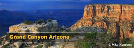
Grand Canyon National Park
Map, Directions and Travel
Last updated on .
Grand Canyon National Park is one of the most visited natural attractions in the United States, drawing travelers from around the world to Northern Arizona for dramatic canyon views, scenic drives, hiking, photography, wildlife, and outdoor adventure. This Grand Canyon map and travel guide helps visitors understand the locations of the South Rim, North Rim, Desert View East Entrance, and nearby gateway cities including Flagstaff and Williams.
Why Visit Grand Canyon National Park
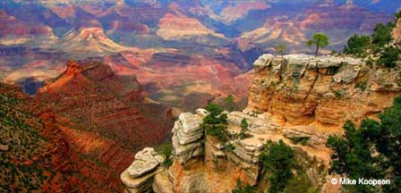
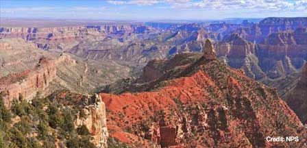
Visitors travel to Grand Canyon National Park to experience one of the world’s most spectacular natural landscapes. The park offers breathtaking overlooks, scenic drives, hiking trails, historic lodges, wildlife viewing, photography opportunities, and unforgettable sunrise and sunset views across the canyon. Whether visiting the South Rim, North Rim, or Desert View area, the Grand Canyon delivers one of Arizona’s most iconic travel experiences.
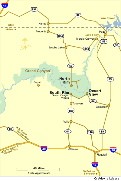
Grand Canyon National Park includes the South Rim, North Rim, and the Desert View East Entrance. The West Rim is separate from Grand Canyon National Park and is owned and operated by the Hualapai Tribe west of Grand Canyon Village.
Grand Canyon Map
Best Times To Visit The Grand Canyon
The South Rim of Grand Canyon National Park is open year-round and remains the most popular area for sightseeing, lodging, and visitor services. North Rim facilities are generally open with good weather from mid-May through mid-October due to heavy winter snowfall and seasonal road closures.
- Spring: Mild temperatures and fewer crowds make spring one of the best seasons for hiking and scenic drives.
- Summer: Peak travel season with warm weather, ranger programs, shuttle service, and full visitor access.
- Fall: Cooler temperatures and changing light conditions create excellent sightseeing and photography opportunities.
- Winter: Snow along the South Rim creates dramatic canyon scenery with fewer visitors and peaceful viewpoints.
Directions To The South Rim
The South Rim of Grand Canyon National Park is 80 to 90 miles northwest of Flagstaff, Arizona depending upon which of three different routes you take. It is approximately 60 miles north of Williams, Arizona. The Grand Canyon is located entirely within the State of Arizona.
To South Rim From Flagstaff, Arizona
1. Take I 40 West about 30 miles to Highway 64 (Exit 165) as you near Williams. Go North on Highway 64 for about 60 miles directly to the South Rim.
2. In downtown Flagstaff, travel North on Humphreys Street to Columbus Avenue which becomes Highway 180. Take Highway 180 West about 55 miles to Highway 64. Head North on Highway 64 directly to Tusayan and the South Rim.
3. Take Route 66 Northeast which will turn into Highway 89. Take Highway 89 North about 65 miles, then turn left (west) onto Highway 64 and continue directly to the East Entrance on the South Rim. The East Entrance is referred to as "Desert View". Desert View is on Desert View Drive which hugs the edge of the canyon for about 26 scenic miles to Grand Canyon Village at the South Rim.
To South Rim From Williams, Arizona
Williams, Arizona is one of the most popular gateway towns to the Grand Canyon South Rim. From Williams, take Highway 64 North approximately 60 miles directly to Grand Canyon National Park. Visitors can also ride the historic Grand Canyon Railway from Williams to the South Rim.
Directions To The North Rim
Keep in mind that although you can see the North Rim from the South Rim and at some points is only about 10 miles as the bird flies to the other side, the driving distance to the North Rim from the South Rim is about 212 miles.
From Flagstaff. The one way trip from Flagstaff to the North Rim is about 207 miles (333 km). Take Highway 89 North to Highway 89A (Alt). Take 89A West to Highway 67. Take 67 South directly to the North Rim.
Directions To The Hualapai West Rim
Click here for directions to the West Rim and SkyWalk.
Grand Canyon Travel Tips
- Arrive Early: Parking lots and viewpoints become crowded during holidays and summer afternoons.
- Check Seasonal Conditions: North Rim roads and facilities close during winter months.
- Bring Layers: Temperatures can change quickly due to elevation differences.
- Plan Fuel Stops: Services are limited in remote areas around the North Rim and eastern routes.
- Allow Extra Driving Time: Distances between the South Rim and North Rim are much longer than they appear on maps.
Convenient Hotels & Lodging
FAQ
Where is Grand Canyon National Park located?
Grand Canyon National Park is located in Northern Arizona and includes the South Rim, North Rim, and Desert View East Entrance.
What is the difference between the South Rim and North Rim?
The South Rim is open year-round and has the most visitor services, while the North Rim is quieter, higher in elevation, and typically open only from mid-May through mid-October.
How far is the Grand Canyon from Flagstaff?
The South Rim of Grand Canyon National Park is approximately 80 to 90 miles north of Flagstaff depending on the route taken.
Can you drive between the South Rim and North Rim?
Yes, but the driving distance between the South Rim and North Rim is about 212 miles and can take several hours.
What is the best time to visit Grand Canyon National Park?
Spring and fall are often considered the best times to visit because of milder temperatures and fewer crowds compared to summer.
Is the Grand Canyon Railway worth taking?
Yes. The Grand Canyon Railway from Williams offers a scenic and historic way to travel directly to the South Rim.
Is the West Rim part of Grand Canyon National Park?
No. The West Rim is operated by the Hualapai Tribe and is separate from Grand Canyon National Park.
More Information
Grand Canyon National Park
Flagstaff Visitors Guide
Flagstaff Tourism Bureau
Williams Chamber of Commerce
The Spectacular Grand Canyon


