

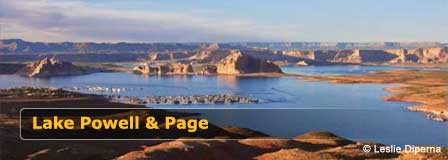
Page Arizona & Lake Powell Map & Driving Directions
Reviewed and updated by AZ Leisure Staff Writers on .
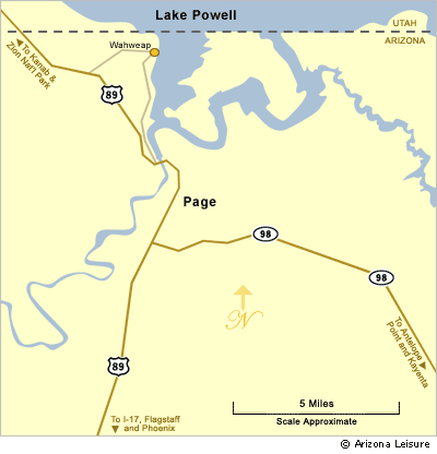
Page, Arizona is the primary gateway to the southern portion of Lake Powell and Glen Canyon National Recreation Area. U.S. Highway 89 connects Page with Flagstaff to the south and southern Utah to the north, while Arizona Highway 98 provides access toward Antelope Point, Navajo Nation communities and Monument Valley.
Page Municipal Airport also provides daily commercial airline service to Phoenix. For travelers bringing boats, outdoor gear or supplies, driving is often the most practical option. The maps and directions below show Page, Lake Powell and the principal southern lake access areas, including Wahweap and Antelope Point.
- Page & Lake Powell Quick Facts
- Page & Lake Powell Area Map
- Directions From Flagstaff
- Directions From Phoenix
- Directions From Las Vegas
- Directions To Wahweap
- Directions To Antelope Point
- Flying To Page Arizona
- Driving & Travel Tips
- FAQ
Page Arizona & Lake Powell Quick Facts
- Primary highway: U.S. Highway 89
- Page Airport: Page Municipal Airport (PGA)
- Commercial air service: Daily service to Phoenix
- Closest major Lake Powell area: Wahweap
- Page to Wahweap: Approximately 8 road miles
- Page to Antelope Point: Approximately 9 road miles
- Wahweap access: U.S. Highway 89 north of Page
- Antelope Point access: Arizona Highway 98 and BIA Highway N22B
- Horseshoe Bend: Approximately 5 miles south of Page on U.S. 89
- Lake access: Boat-ramp availability changes with Lake Powell water levels
Page Arizona & Lake Powell Area Map
The map below provides an overview of Page, Lake Powell and surrounding highways and recreation areas. Use it for regional orientation, but check current navigation and National Park Service information before traveling because lake access and boat-ramp conditions can change with reservoir levels.
Directions To Page Arizona From Flagstaff
From Flagstaff, take U.S. Highway 89 north toward Cameron and Page. Continue on U.S. 89 through the high-desert landscape of northern Arizona to Page. The drive is roughly 130 miles and generally takes a little over two hours without extended stops.
After reaching Page, continue north on U.S. 89 for Wahweap and Glen Canyon Dam, or use Arizona Highway 98 for Antelope Point and destinations east of Page.
Directions To Page Arizona From Phoenix
From the Phoenix area, take Interstate 17 north to Flagstaff, then continue north on U.S. Highway 89 toward Cameron and Page. Page is approximately 275 miles from central Phoenix, and normal driving time is roughly 4½ hours without extended sightseeing stops.
This route passes through significant elevation changes, so winter travelers should check road conditions around Flagstaff before departing.
Directions To Page Arizona From Las Vegas
From Las Vegas, travel northeast through southern Utah toward Kanab, then continue east and south toward Page on U.S. Highway 89. Driving time is generally about 4½ hours, depending on traffic, stops and road conditions.
Travelers should confirm the preferred route with current navigation before departure because road construction, weather or regional closures can affect northern Arizona and southern Utah highways.
Directions To Wahweap & Lake Powell Resort
Wahweap is the principal Lake Powell recreation area closest to Page. From Page, travel north on U.S. Highway 89 toward Glen Canyon Dam and the Arizona-Utah state line. The Wahweap South Entrance is the closest entrance to Page and provides access to Lake Powell Resort, Wahweap Marina, recreation facilities and lake views.
Wahweap is approximately 8 road miles from Page. Boat-launch availability changes with lake elevation, so visitors towing boats should check current National Park Service ramp conditions before driving to the lake.
Directions To Antelope Point Marina
From Page, travel east on Arizona Highway 98 for approximately 3 miles, then turn north on BIA Highway N22B toward Antelope Point Marina and the Antelope Point public launch area.
Antelope Point is approximately 9 road miles from Page and provides another major access point to the southern portion of Lake Powell. Boat-launch availability varies with lake elevation, so check current National Park Service conditions before traveling with a boat.
Flying To Page Arizona
Page Municipal Airport is a commercial-service airport located in Page. Contour Airlines currently provides daily scheduled service between Page and Phoenix.
Rental cars are available at Page Airport, and charter flights and scenic air tours are also offered by several aviation companies serving the region.
Lake Powell Boat Ramp & Marina Access
Lake Powell water levels can affect which launch ramps are available for motorized boats. Wahweap, Stateline and other ramps have different minimum operating elevations, and conditions can change during the boating season.
Before towing a boat to Lake Powell, check current National Park Service lake-level and launch-ramp information. Do not rely solely on older printed maps or previous-trip experience when choosing a launch location.
Page Arizona & Lake Powell Driving Tips
- Check current highway and weather conditions before long-distance travel.
- Carry drinking water, especially during warmer months.
- Keep the fuel tank reasonably full when traveling through remote northern Arizona and southern Utah.
- Expect limited cell-phone service in some areas outside Page.
- Check Lake Powell launch-ramp conditions before towing a boat.
- Allow extra travel time during summer, holiday weekends and major events.
- Watch carefully for wildlife when driving before sunrise or after dark.
- Remember that Page remains on Mountain Standard Time year-round.
- Nearby Navajo Nation communities generally observe Daylight Saving Time.
- Use current navigation in addition to the regional map shown on this page.
Page Arizona & Lake Powell Directions FAQ
Where Is Page Arizona?
Page is located in northern Arizona near the Utah border, Glen Canyon Dam and the southern portion of Lake Powell.
What Highway Goes To Page Arizona?
U.S. Highway 89 is the primary north-south highway serving Page. Arizona Highway 98 provides access east toward Antelope Point and Navajo Nation communities.
How Far Is Page Arizona From Flagstaff?
Page is roughly 130 miles north of Flagstaff by way of U.S. Highway 89.
How Far Is Lake Powell From Page Arizona?
Lake Powell access is only a few miles from Page. Wahweap is approximately 8 road miles away, while Antelope Point is approximately 9 road miles from Page.
What Is The Closest Lake Powell Marina To Page?
Wahweap and Antelope Point are the primary marina areas near Page. Which is most convenient depends on the visitor's destination, boat-launch needs and current lake conditions.
How Do You Get To Wahweap From Page?
Take U.S. Highway 89 north from Page toward Glen Canyon Dam and the Utah state line, then follow signs to the Wahweap South Entrance and Lake Powell Resort.
How Do You Get To Antelope Point From Page?
Travel east from Page on Arizona Highway 98, then turn north on BIA Highway N22B toward Antelope Point Marina.
Can You Fly To Page Arizona?
Yes. Page Municipal Airport has scheduled commercial airline service to Phoenix, currently provided by Contour Airlines.
Are Lake Powell Boat Ramps Always Open?
No. Boat-ramp availability depends partly on Lake Powell water elevation, maintenance and seasonal conditions. Check current National Park Service information before launching.
Is Page Arizona On The Same Time As Utah?
Not always. Page remains on Mountain Standard Time year-round, while Utah observes Daylight Saving Time. During Daylight Saving Time, Utah is one hour ahead of Page.
More Page Arizona & Lake Powell Information
- Page Arizona Visitor Guide
- Lake Powell Arizona
- Lake Powell Map & Directions
- Lake Powell Marinas
- Wahweap Marina
- Antelope Point Marina
- Horseshoe Bend
- Antelope Canyon
- Glen Canyon Dam
- Page Arizona Weather
Lake Powell & Page Arizona















