

Glen Canyon Dam and Glen Canyon Bridge
Updated by AZ Leisure Staff Writers on
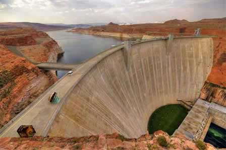 Glen Canyon Dam Forming Lake Powell. Creative Commons
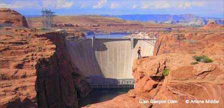
Glen Canyon Dam rises above the Colorado River near Page, Arizona and creates Lake Powell, the immense reservoir at the heart of Glen Canyon National Recreation Area. Completed as a major feature of the Colorado River Storage Project, the concrete arch dam provides long-term water storage, regulates Colorado River flows and generates hydroelectric power. Visitors can learn about the dam at the Carl Hayden Visitor Center, view the structure and Glen Canyon Bridge from several overlooks, and explore Lake Powell and other nearby northern Arizona attractions.
- Glen Canyon Dam Facts
- Dam History
- Lake Powell
- Water Storage & Hydropower
- Glen Canyon Bridge
- Carl Hayden Visitor Center
- Directions
- Nearby Attractions
- FAQ
Glen Canyon Dam Facts
- Dam type: Concrete arch dam
- Colorado River location: Near Page, Arizona
- Structural height: 710 feet above bedrock
- Height above original river channel: 583 feet
- Crest length: 1,560 feet
- Maximum base thickness: 300 feet
- Generating units: 8
- Installed generating capacity: 1,320 megawatts
- Lake Powell storage began: March 13, 1963
- Lake Powell first reached full elevation: June 22, 1980
- Lake Powell full-storage capacity: Approximately 25.16 million acre-feet
Water Storage And Hydroelectric Power
Glen Canyon Dam is the principal water-storage feature of the Colorado River Storage Project. Lake Powell functions as a major reservoir for the Colorado River Basin, storing water that can be released during dry periods while helping the Upper Colorado River Basin meet downstream delivery obligations.
The Glen Canyon Powerplant contains eight hydroelectric generating units with a combined installed capacity of approximately 1,320 megawatts. Hydroelectric power from the dam is distributed throughout several western states, while power revenues also help support environmental and resource-management programs associated with Glen Canyon and the Colorado River.
History Of Glen Canyon Dam
Construction of Glen Canyon Dam began after Congress authorized the Colorado River Storage Project in 1956. The first ceremonial blast occurred on October 15, 1956, and construction crews began placing concrete in June 1960. More than 400,000 buckets of concrete were used to construct the massive arch dam.
Lake Powell began forming in March 1963 when the Colorado River diversion tunnels were closed. The final concrete was placed in the dam on September 13, 1963, and the project was formally dedicated in 1966. Because of the enormous size of the reservoir, Lake Powell required 17 years to fill for the first time, reaching elevation 3,700 feet on June 22, 1980.
Glen Canyon Dam And Lake Powell
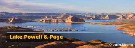
Glen Canyon Dam impounds Lake Powell, one of the largest reservoirs in the United States and the centerpiece of Glen Canyon National Recreation Area. At full elevation, Lake Powell extends approximately 186 miles and has about 1,960 miles of shoreline, although actual lake dimensions and shoreline access vary with reservoir levels.
Lake Powell is known for boating, houseboating, paddling, fishing and dramatic red-rock canyon scenery. The surrounding recreation area encompasses approximately 1.25 million acres of canyon country extending across northern Arizona and southern Utah.
Glen Canyon Bridge
Glen Canyon Bridge carries U.S. Highway 89 across the Colorado River immediately downstream from Glen Canyon Dam. The steel-arch bridge was built to provide construction access to the remote dam site and was completed in January 1959.
The bridge has a total deck length of 1,271 feet and stands approximately 700 feet above the Colorado River. Before the bridge was built, crossing the canyon required a detour of roughly 200 miles. When completed, it was the highest arch bridge in the world.
Glen Canyon National Recreation Area And Page Arizona
Page, Arizona developed during construction of Glen Canyon Dam and today serves as the principal gateway community for Lake Powell and the surrounding recreation area. Hotels, restaurants, outfitters and visitor services make Page a convenient base for exploring the dam, Lake Powell, Horseshoe Bend, Antelope Canyon and other northern Arizona destinations.
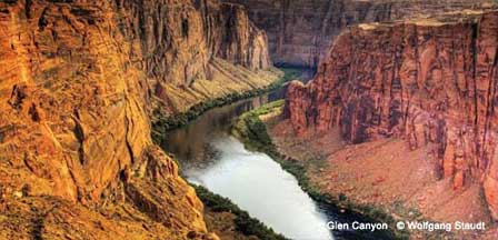
Glen Canyon National Recreation Area extends across a vast landscape of sandstone cliffs, narrow canyons, desert terrain and Colorado River scenery. Visitors can spend a short stop viewing Glen Canyon Dam or several days boating, hiking, camping and exploring the Lake Powell region.
Carl Hayden Visitor Center
The Carl Hayden Visitor Center sits beside Glen Canyon Dam on U.S. Highway 89 and provides one of the best places to learn about the dam, Lake Powell and the Colorado River. Exhibits focus on water use, recreation and the history of Glen Canyon, while large windows provide views of Glen Canyon Dam, the bridge, Lake Powell and the powerplant.
The visitor center is currently open daily from 9:00 AM to 5:00 PM during the main season, with shorter winter hours beginning in November. Public tours inside Glen Canyon Dam are currently closed. Visitors should check the National Park Service website for current hours, closures and program information before traveling.
Carl Hayden Visitor Center
U.S. Highway 89 at Glen Canyon Dam
Page, Arizona 86040
928-608-6200
2026 Ranger Programs
Although public tours inside Glen Canyon Dam are closed, the National Park Service is offering selected ranger programs at the Carl Hayden Visitor Center during summer 2026. Program schedules vary, so check the current park calendar before visiting.
Directions To Glen Canyon Dam
Glen Canyon Dam is located on U.S. Highway 89 approximately 2 miles north of Page, Arizona. The highway crosses the Colorado River on Glen Canyon Bridge directly beside the dam and Carl Hayden Visitor Center.
From Flagstaff, travel north on U.S. Highway 89 toward Page. Visitors arriving from Page can follow U.S. 89 north to the dam and visitor-center parking area. Check current highway and recreation-area conditions before traveling.
Nearby Glen Canyon Dam Attractions
- Glen Canyon Dam Overlook
- Lake Powell
- Horseshoe Bend
- Antelope Canyon
- Lees Ferry
- Marble Canyon
- Rainbow Bridge National Monument
- Vermilion Cliffs
- Page Arizona
Frequently Asked Questions About Glen Canyon Dam
Where is Glen Canyon Dam?
Glen Canyon Dam is located on the Colorado River beside U.S. Highway 89 approximately 2 miles north of Page, Arizona.
How tall is Glen Canyon Dam?
Glen Canyon Dam rises 710 feet above its bedrock foundation. It is approximately 583 feet above the original Colorado River channel.
How long is Glen Canyon Dam?
The crest of Glen Canyon Dam extends approximately 1,560 feet across Glen Canyon.
What lake does Glen Canyon Dam create?
Glen Canyon Dam impounds Lake Powell, one of the largest reservoirs in the United States and the centerpiece of Glen Canyon National Recreation Area.
Why was Glen Canyon Dam built?
The dam was constructed as a major feature of the Colorado River Storage Project to provide water storage, regulate Colorado River flows and generate hydroelectric power.
Can you tour Glen Canyon Dam?
Public tours inside Glen Canyon Dam are currently closed. The Carl Hayden Visitor Center remains open and offers exhibits, ranger information and views of the dam, bridge, Lake Powell and powerplant.
When was Glen Canyon Dam built?
Construction began in the late 1950s. Concrete placement began in 1960, Lake Powell began forming in 1963, and the project was formally dedicated in 1966.
How long did Lake Powell take to fill?
Lake Powell began storing water in March 1963 and first reached full elevation on June 22, 1980, approximately 17 years later.
How high is Glen Canyon Bridge?
Glen Canyon Bridge stands approximately 700 feet above the Colorado River and has a total deck length of 1,271 feet.
Lake Powell & Page Arizona
Area Attractions
About Glen Canyon Dam
Marble Canyon
Rainbow Bridge Monument
Horseshoe Bend
Lees Ferry
Navajo National Monument
Vermilion Cliffs Nat'l Monument
Dam Overlook















