

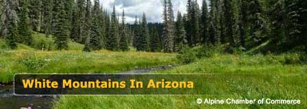
Pinetop-Lakeside Arizona Map & Driving Directions
Reviewed and updated by AZ Leisure Staff Writers on .
Pinetop-Lakeside is a mountain community in Arizona's White Mountains, located about 15 miles from Show Low along State Route 260. This map and directions guide shows where Pinetop-Lakeside is located and outlines the main driving routes from Phoenix, Tucson and other parts of Arizona.
From Phoenix, travelers can reach Pinetop-Lakeside through Payson and the Mogollon Rim on State Route 260 or through Globe and the Salt River Canyon on US 60. Under normal conditions, the drive from Phoenix is approximately 3.5 hours. Pinetop-Lakeside also provides a convenient base for Rainbow Lake, Woodland Lake, Show Low, Greer, Sunrise Park Resort and other White Mountains destinations.
- Pinetop-Lakeside Map
- Directions From Phoenix
- Directions From Tucson
- From Show Low
- Which Route Is Best?
- Winter Driving
- Nearby Destinations
- Travel Tips
- FAQ
Pinetop-Lakeside Driving Times At A Glance
- From Phoenix: Approximately 3.5 hours under normal conditions.
- From Tucson: Approximately 4 hours under normal conditions.
- From Show Low: Approximately 15 miles by State Route 260/White Mountain Boulevard.
- From Phoenix via Payson: State Route 87 north to Payson, then State Route 260 east.
- From Phoenix via Globe: US 60 east through Globe and the Salt River Canyon to Show Low.
Pinetop-Lakeside Arizona Map
The map below shows Pinetop-Lakeside within Arizona's White Mountains and its relationship to Show Low, nearby communities, lakes and regional highways. State Route 260 is the primary highway through Pinetop-Lakeside and connects the community with Show Low and other White Mountains destinations.
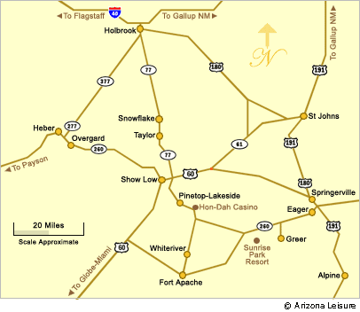
Use the map to plan travel throughout the White Mountains, including side trips to Rainbow Lake, Woodland Lake, Show Low, Greer, Sunrise Park Resort and nearby recreation areas. Pinetop-Lakeside sits at approximately 7,000 feet in elevation, so weather and road conditions can differ significantly from Phoenix and other lower-elevation Arizona communities.
Directions From Phoenix To Pinetop-Lakeside
Pinetop-Lakeside is approximately a 3.5-hour drive from Phoenix under normal conditions. Two primary routes are commonly used.
Payson and Mogollon Rim Route: Take State Route 87 north from the Phoenix area to Payson. In Payson, take State Route 260 east across the Mogollon Rim toward Show Low. Continue through Show Low on State Route 260/White Mountain Boulevard for approximately 15 miles to Pinetop-Lakeside.
Globe and Salt River Canyon Route: Take US 60 east from the Phoenix area through Globe and continue on US 60 through the Salt River Canyon to Show Low. From Show Low, turn onto State Route 260/White Mountain Boulevard and continue approximately 15 miles to Pinetop-Lakeside.
Directions From Tucson To Pinetop-Lakeside
The drive from Tucson to Pinetop-Lakeside is approximately four hours under normal conditions. Travel north toward Oracle Junction, continue north on State Route 77 to Globe, then take US 60 through the Salt River Canyon to Show Low. From Show Low, take State Route 260/White Mountain Boulevard approximately 15 miles to Pinetop-Lakeside.
Directions From Show Low To Pinetop-Lakeside
Pinetop-Lakeside is about 15 miles from Show Low. From Show Low, follow State Route 260/White Mountain Boulevard southeast toward Lakeside and Pinetop. The route is direct and serves as the primary local connection between the two communities.
Which Phoenix Route To Pinetop-Lakeside Is Best?
Both major Phoenix routes reach Pinetop-Lakeside through Show Low, but they provide very different driving experiences. The Payson route follows State Route 87 and State Route 260 across the Mogollon Rim, while the US 60 route passes through Globe and the Salt River Canyon.
- Via Payson: A popular route for travelers coming from central and north Phoenix and for those who want to travel through Payson and the Mogollon Rim.
- Via Globe: Useful for travelers coming from parts of the East Valley and for those who prefer the US 60 route through Globe and Salt River Canyon.
- Before leaving: Compare current traffic, construction, weather and road conditions rather than assuming one route will always be faster.
Winter Driving To Pinetop-Lakeside
Winter storms can bring snow, ice and rapidly changing road conditions to Pinetop-Lakeside and the surrounding White Mountains. Conditions can also affect State Route 260, US 60 and other high-country roads leading into the area.
Before driving during winter weather, check current Arizona highway conditions through AZ511 as well as the local Pinetop-Lakeside forecast. Conditions on State Route 260, US 60 and the Salt River Canyon can change rapidly during mountain storms. Allow extra travel time, make sure your vehicle is prepared for freezing temperatures and winter conditions, and never rely solely on normal drive-time estimates during a storm.
Getting Around Pinetop-Lakeside
State Route 260/White Mountain Boulevard is the main travel corridor through Pinetop-Lakeside and provides access to lodging, restaurants, shopping and local roads leading to neighborhoods and recreation areas. Rainbow Lake, Woodland Lake and many local destinations are reached from streets branching from the State Route 260 corridor.
For detailed local streets and neighborhoods, use the interactive map above or the Town of Pinetop-Lakeside's current visitor map in addition to the regional White Mountains map.
Nearby White Mountains Destinations
Pinetop-Lakeside's location makes it a convenient starting point for visiting mountain lakes, recreation areas and neighboring communities throughout eastern Arizona.
- Show Low: The nearest major neighboring community and the primary highway connection for travelers arriving from Phoenix or Tucson.
- Rainbow Lake: Popular local lake near Lakeside for fishing, boating and scenic recreation.
- Woodland Lake: Convenient Pinetop recreation area with fishing, walking and picnic opportunities.
- Greer: Scenic White Mountains community northeast of Pinetop-Lakeside.
- Sunrise Park Resort: Year-round mountain recreation destination southeast of Pinetop-Lakeside.
- White Mountains Lakes: Numerous fishing and recreation lakes are accessible throughout the broader region.
Pinetop-Lakeside Driving & Travel Tips
- Check current Arizona highway and weather conditions before leaving.
- Allow additional driving time during winter storms, holiday periods and road construction.
- Remember that Pinetop-Lakeside sits at approximately 7,000 feet, so temperatures can be much cooler than Phoenix or Tucson.
- Carry water and basic emergency supplies when traveling through remote mountain areas.
- Keep your fuel level adequate before long stretches through the White Mountains.
- Use current navigation for your final local destination rather than relying only on older printed directions.
- Check lodging and campground access before arrival during winter weather.
Pinetop-Lakeside Map & Directions FAQ
Where Is Pinetop-Lakeside Arizona?
Pinetop-Lakeside is located in Arizona's White Mountains in Navajo County, about 15 miles from Show Low along State Route 260.
How Far Is Pinetop-Lakeside From Show Low?
Pinetop-Lakeside is approximately 15 miles from Show Low by State Route 260/White Mountain Boulevard.
How Long Does It Take To Drive From Phoenix To Pinetop-Lakeside?
The drive from Phoenix is approximately 3.5 hours under normal conditions. Actual travel time depends on starting location, route, traffic, construction and weather.
What Is The Best Route From Phoenix To Pinetop-Lakeside?
Two common routes are available. One travels through Payson using State Routes 87 and 260, while the other follows US 60 through Globe and the Salt River Canyon. The better choice depends on your starting point and current road conditions.
How Long Does It Take To Drive From Tucson To Pinetop-Lakeside?
The drive from Tucson is approximately four hours under normal conditions, generally using State Route 77 toward Globe, then US 60 through Salt River Canyon and State Route 260 from Show Low.
What Highway Goes Through Pinetop-Lakeside?
State Route 260, known locally as White Mountain Boulevard through much of the community, is the primary highway through Pinetop-Lakeside.
Does It Snow On The Drive To Pinetop-Lakeside?
Yes. Winter storms can bring snow and ice to Pinetop-Lakeside and high-elevation highways in the White Mountains. Check current road and weather conditions before winter travel.
What Is The Elevation Of Pinetop-Lakeside?
Pinetop-Lakeside sits at approximately 7,000 feet above sea level.
What Lakes Are Near Pinetop-Lakeside?
Nearby lakes include Rainbow Lake, Woodland Lake and Show Low Lake, with Big Lake, Hawley Lake and numerous other White Mountains waters reachable on longer day trips.
Can You Use Pinetop-Lakeside As A Base For Exploring The White Mountains?
Yes. Pinetop-Lakeside provides convenient access to Show Low, Greer, Sunrise Park Resort, nearby mountain lakes, forest recreation and other White Mountains destinations.
Related Pinetop-Lakeside Information
Pinetop-Lakeside
Average Temps-Weather Pinetop-Lakeside
Pinetop-Lakeside Map & Directions
Pinetop-Lakeside RV Parks
Beautiful White Mountains In Arizona
White Mountains
Map & Directions
Little Colorado River
Weather & Climate
Alpine Arizona
Heber/Overgaard
Pinetop-Lakeside
Payson Arizona
About Show Low
Snowflake/Taylor
Springerville Arizona
Greer Arizona
Popular Area Lakes
Rainbow Lake
White Mountains Lakes
Big Lake
Hawley Lake
Show Low Lake
Crescent Lake
Woodland Lake
Luna Lake
Becker Lake
Fool Hollow Lake
Lyman Lake















