

Show Low Arizona & White Mountains Driving Distance Guide
Reviewed and updated by AZ Leisure Staff Writers on
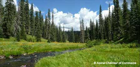
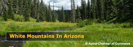
This White Mountains distance guide provides approximate driving miles to Show Low Arizona from communities throughout the White Mountains and from major cities across Arizona. Show Low is one of the region's principal communities and a convenient reference point for planning trips to Pinetop-Lakeside, Greer, Alpine, Springerville, Heber-Overgaard and other destinations in Arizona's high country.
Driving distances are approximate and can vary according to your exact starting point, destination, chosen route, road conditions and seasonal closures. Mountain highways may also require additional travel time during winter storms, summer monsoon weather or periods of wildfire activity.
- White Mountains Town Distances
- Arizona City Distances
- White Mountains Travel Planning
- Major Routes To Show Low
- Where To Stay
- FAQ
Driving Miles From White Mountains Towns To Show Low
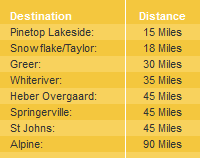
Use the chart below to compare approximate driving distances from communities throughout Arizona's White Mountains to Show Low. Actual mileage can vary depending on your starting location and route.
Driving Miles From Arizona Cities To Show Low
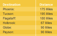
The following chart provides approximate driving distances to Show Low from major Arizona cities and communities. These figures are useful for trip planning, but mileage can vary by route and specific departure point.
Planning A Trip To Arizona's White Mountains
Driving distance is only part of planning a White Mountains trip. Elevation, weather and mountain-road conditions can affect travel times throughout the year. Summer generally offers the easiest access, although afternoon thunderstorms can produce heavy rain. Winter visitors should be prepared for snow and icy roads, particularly on higher-elevation routes.
- Check road conditions: Review current highway conditions before traveling during winter storms, wildfire activity or severe weather.
- Allow extra time: Mountain highways can be slower than similarly sized highways in lower elevations.
- Watch for wildlife: Elk, deer and other wildlife may cross highways, particularly around dawn and dusk.
- Plan fuel stops: Services can be less frequent when traveling toward remote White Mountains destinations.
- Prepare for elevation: Temperatures can be considerably cooler than Phoenix and other lower-desert communities.
Major Driving Routes To Show Low Arizona
Show Low is served by several important highways that connect the White Mountains with other parts of Arizona. State Route 260 approaches the area from the west through Rim Country and continues through the White Mountains, while U.S. Route 60 and State Route 77 provide additional access from central and eastern Arizona.
- From the Phoenix area: Travelers commonly reach the White Mountains through Payson and State Route 260 or by routes connecting with U.S. Route 60.
- From Payson: State Route 260 continues east through Mogollon Rim Country toward Heber-Overgaard and Show Low.
- From Pinetop-Lakeside: State Route 260 connects directly with Show Low.
- From Springerville and Eagar: U.S. Route 60 connects the Round Valley area with Show Low.
- From Alpine: Travelers generally use White Mountains highways through Springerville-Eagar or other regional routes depending on road conditions and destination.
Where To Stay In Arizona's White Mountains
Travelers can choose from hotels, motels, cabins, lodges, bed and breakfast inns, RV parks and campgrounds throughout the White Mountains. Show Low and Pinetop-Lakeside offer convenient lodging near shopping, restaurants and recreation, while smaller mountain communities provide additional high-country accommodations.
Explore White Mountains bed and breakfast inns, cabins and lodges, Pinetop-Lakeside cabins, Show Low cabin rentals and RV parks and campgrounds.
Show Low & White Mountains Distance Guide FAQ
Where is Show Low Arizona?
Show Low is located in eastern Arizona in the White Mountains region of Navajo County. It is one of the area's principal communities and a convenient base for exploring Pinetop-Lakeside, nearby lakes, trails and other high-country destinations.
Are the driving distances on this page exact?
No. The mileages are approximate and can vary according to your exact starting point, destination and chosen driving route.
What highways serve Show Low Arizona?
Major highways serving Show Low include U.S. Route 60, State Route 260 and State Route 77.
What White Mountains towns are near Show Low?
Nearby and regional White Mountains communities include Pinetop-Lakeside, Heber-Overgaard, Greer, Springerville, Eagar and Alpine.
How do you drive to Show Low from the Phoenix area?
Several routes connect the Phoenix area with Show Low. A common route travels through Payson and continues east on State Route 260 through Rim Country toward the White Mountains. Other routes may use U.S. Route 60 depending on the starting location and current road conditions.
Can winter weather affect driving to Show Low?
Yes. Snow, ice and freezing temperatures can affect White Mountains highways during winter. Travelers should check current highway and weather conditions before departing.
Is Show Low a good base for exploring the White Mountains?
Yes. Show Low provides lodging, restaurants and services along with convenient access to Pinetop-Lakeside, mountain lakes, forest trails and other White Mountains recreation areas.
Should I plan extra driving time in the White Mountains?
Yes. Mountain roads, weather, wildlife, construction and seasonal traffic can all increase travel time, so it is wise to allow additional time beyond normal mileage estimates.
Related White Mountains Travel Information
Show Low Arizona
White Mountains Map & Directions
White Mountains Weather & Climate
Pinetop-Lakeside Arizona
Heber-Overgaard Arizona
Beautiful White Mountains In Arizona
White Mountains
Map & Directions
Little Colorado River
Weather & Climate
Alpine Arizona
Heber/Overgaard
Pinetop-Lakeside
Payson Arizona
About Show Low
Snowflake/Taylor
Springerville Arizona
Greer Arizona
Popular Area Lakes
Rainbow Lake
White Mountains Lakes
Big Lake
Hawley Lake
Show Low Lake
Crescent Lake
Woodland Lake
Luna Lake
Becker Lake
Fool Hollow Lake
Lyman Lake















