
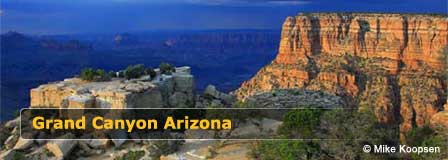
Where Is the Grand Canyon Located?
Last updated on .
The Grand Canyon is located in Northern Arizona and is one of the most famous natural landmarks in the world. Grand Canyon National Park is divided mainly between the South Rim and North Rim, with the South Rim serving as the most visited and easiest-to-access area for first-time travelers, families, road trips, scenic overlooks, hotels, restaurants, shuttle buses, and year-round visitor services.
The Grand Canyon stretches for about 277 miles across Northern Arizona, with the Colorado River flowing through the canyon from east to west. Grand Canyon National Park includes the heavily visited South Rim, the more remote North Rim, and several scenic access points, overlooks, drives, trails, and visitor areas that help travelers experience the canyon from different perspectives.
Why Visit The Grand Canyon
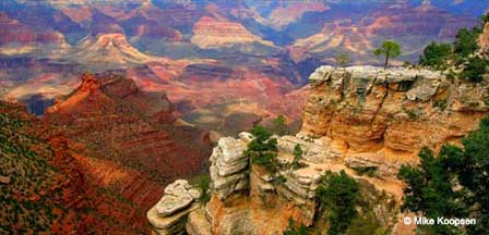
The Grand Canyon is worth visiting for its vast desert views, colorful rock layers, dramatic overlooks, hiking trails, wildlife, photography, historic sites, and unforgettable sunrise and sunset scenery. Whether visiting the South Rim for classic viewpoints, the North Rim for a quieter mountain setting, or nearby areas such as Desert View, Grand Canyon Village, or Grand Canyon West, the canyon offers one of the most memorable travel experiences in Arizona.
Distance From Major Cities To The Grand Canyon
- From Phoenix: About 230 miles to the Grand Canyon South Rim, depending on route and destination inside the park.
- From Flagstaff: About 80 miles to the Grand Canyon South Rim, making Flagstaff one of the most convenient larger cities nearby.
- From Williams: About 60 miles to the South Rim entrance, with access by road and the Grand Canyon Railway.
- From Sedona: About 110 miles to the South Rim, often reached by a scenic drive through Oak Creek Canyon and Flagstaff.
- From Las Vegas: About 275 miles to the South Rim and a shorter drive to Grand Canyon West, depending on the route selected.
- From Page: About 135 miles to the South Rim via Northern Arizona routes and nearby canyon country.
- From Tucson: About 340 miles to the South Rim, usually routed through Phoenix or Flagstaff.
Prime Areas To Visit At The Grand Canyon
- Grand Canyon South Rim: The most visited section, open year-round with viewpoints, lodging, restaurants, shuttle buses, trails, and visitor services.
- Grand Canyon North Rim: A quieter, higher-elevation area with cooler temperatures, forest scenery, and seasonal access.
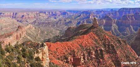
- Grand Canyon East Rim: Scenic canyon country near Desert View, the Colorado River, and routes toward Page and Lake Powell.
- Grand Canyon West Rim: Known for Grand Canyon West, the Skywalk area, and access from the Las Vegas region.
- Desert View Scenic Drive: A beautiful South Rim drive with overlooks, canyon views, and access toward the East Entrance.
- Grand Canyon Skywalk: A glass bridge attraction at Grand Canyon West operated by the Hualapai Tribe.
- Havasu Falls: A famous waterfall destination near Supai requiring advance planning and permits.
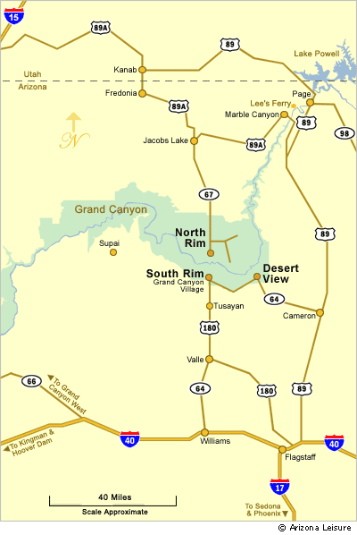
Even though the visual distance from the South to the North Rim averages only about 10 miles across the canyon, the driving distance between the two sides is 220 miles, about a 5-hour drive. The overwhelming number of tourists visit the Grand Canyon South Rim due to many reasons. The South Rim of The Grand Canyon is open all-year, is easily reached, and substantially features more amenities including restaurants, shopping venues, hotels, campgrounds, and an extensive complimentary bus transportation to services and view points.
Best Times To Visit The Grand Canyon
- Spring: Mild temperatures, clearer views, blooming desert plants, and strong hiking conditions make spring one of the best times to visit.
- Summer: The busiest season, with full services, warm weather, large crowds, and very hot inner-canyon temperatures.
- Fall: Comfortable weather, fewer crowds, colorful forest areas, and excellent photography conditions make fall a favorite season.
- Winter: Quieter conditions, possible snow on the rims, crisp canyon views, and fewer visitors create a peaceful experience.
North Rim services close during the winter months due to heavy snow. Although views of the canyon are somewhat similar, the climate and vegetation differs primarily due to elevation. South Rim elevation ranges from 6,500 to 7,600 feet versus 7,500 to 8,600 feet at the North Rim.
Nearest Cities To The Grand Canyon South Rim
The nearest towns and cities near the Grand Canyon South Rim, all with a selection of hotels, restaurants, shopping, and travel services, include Tusayan, Williams, Flagstaff, and Sedona, Arizona.
Tusayan, Arizona: 2 miles south of the main entrance.
Williams, Arizona: Located off Interstate 40 and surrounded by beautiful pine forest. The population of William AZ is about 6,000 and is located about 60 miles from the main Grand Canyon entrance.
Flagstaff, Arizona: Population is about 60,000 is set in pristine forests. Flagstaff boasts the highest mountain range in Arizona, the San Francisco Peaks at 1,600 feet. Flagstaff is located less than 80 miles to both the Main Entrance and the East Entrance of the South Rim of the Grand Canyon.
Sedona, Arizona: Amazing Sedona AZ, is about 110 miles south of the Grand Canyon and the scenic drive up Oak Creek Canyon is spectacular.
Grand Canyon National Park Map
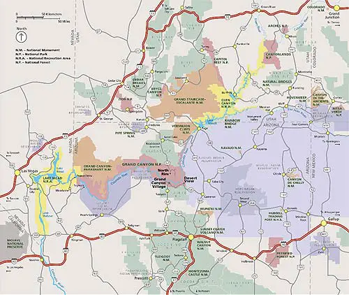
Directional Map To The Grand Canyon
FAQ
Where is the Grand Canyon located?
The Grand Canyon is located in Northern Arizona, with Grand Canyon National Park divided mainly between the South Rim and North Rim.
What are the closest towns and cities to the Grand Canyon?
The closest towns and cities near the Grand Canyon South Rim include Tusayan, Williams, Flagstaff, and Sedona, Arizona.
What is the difference between the South Rim and North Rim?
The South Rim is more heavily visited, open year-round, and offers more hotels, restaurants, campgrounds, shuttle buses, and visitor services. The North Rim is quieter, higher in elevation, more forested, and closes during winter due to snow.
How far is the South Rim from the North Rim of the Grand Canyon?
Although the canyon may appear much narrower visually, the driving distance between the South Rim and North Rim is about 220 miles and typically takes around 5 hours.
How long is the Grand Canyon?
The Grand Canyon stretches for approximately 277 miles across Northern Arizona.
What is the elevation of the Grand Canyon?
South Rim elevations generally range from about 6,500 to 7,600 feet, while the North Rim ranges from about 7,500 to 8,600 feet.
How do you get to the Grand Canyon?
Most visitors reach the Grand Canyon South Rim by driving from Phoenix, Flagstaff, Williams, Las Vegas, or Page using Arizona highways and Interstate 40 connections.
Which Grand Canyon rim is most popular?
The South Rim is the most popular and most visited area because it is open year-round and has the most visitor amenities and scenic viewpoints.
Is the Grand Canyon in Arizona or Nevada?
Grand Canyon National Park is located in Arizona. Grand Canyon West is also located in Arizona near the Nevada border and Las Vegas travel region.
When is the best time to visit the Grand Canyon?
Spring and fall are often considered the best times to visit because temperatures are milder and crowds are usually smaller than during peak summer months.
The Spectacular Grand Canyon


