

Payson Arizona Map, Driving Directions & Rim Country Routes
Reviewed and updated by AZ Leisure Staff Writers on .
Payson, Arizona is located in central Arizona at the junction of State Routes 87 and 260, approximately 5,000 feet above sea level near the base of the Mogollon Rim. State Route 87, commonly called the Beeline Highway, provides the primary route from the Phoenix metropolitan area, while SR 260 connects Payson with Camp Verde, Christopher Creek and Rim Country destinations to the east.
This Payson map and driving guide provides regional orientation, routes from Phoenix and Flagstaff, approximate driving distances and access information for the Mogollon Rim, nearby fishing lakes, campgrounds and surrounding mountain communities.
- Payson Map Quick Facts
- Payson Area Map
- Directions From Phoenix
- Directions From Flagstaff
- Mogollon Rim Access
- Nearby Lakes
- Driving Distances
- Scenic Drives
- Driving Tips
- FAQ
Payson Arizona Map Quick Facts
- Location: Central Arizona in Gila County
- Elevation: Approximately 5,000 feet
- Primary north-south route: State Route 87 / Beeline Highway
- Primary east-west route: State Route 260
- Phoenix area: Approximately 80 to 90 miles depending on starting point
- Flagstaff: Approximately 90 miles by common highway routes
- Nearby communities: Pine, Strawberry, Star Valley and Christopher Creek
- Major recreation area: Mogollon Rim
- Popular nearby lakes: Woods Canyon, Willow Springs, Bear Canyon, Knoll and C.C. Cragin Reservoir
- Regional setting: Tonto National Forest and Arizona Rim Country
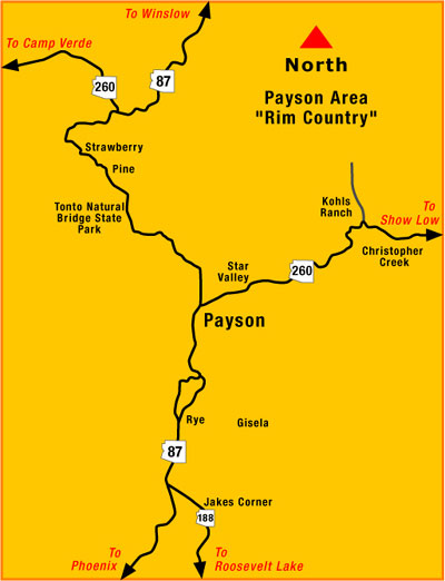
Payson Arizona & Rim Country Area Map
This regional map shows Payson and surrounding Rim Country communities, highways and recreation areas. Use it for general orientation together with current navigation and road-condition information when planning individual trips.
Why Visit Payson Arizona
Payson attracts visitors year-round with its cooler mountain climate, beautiful pine forests, scenic highways, hiking trails, wildlife viewing, Payson area fishing lakes, and relaxing cabin destinations. Located along the Beeline Highway and surrounded by the Tonto National Forest, Payson serves as a gateway to the Mogollon Rim and many of Arizona’s most scenic outdoor recreation areas.
Things To Do & See Around Payson
- Mogollon Rim: One of Arizona’s most scenic mountain overlooks with dramatic forest and canyon views.
- Tonto Natural Bridge State Park: Famous natural travertine bridge with hiking trails and picnic areas.
- Christopher Creek: Popular area for cabins, creekside camping, fishing, and relaxing mountain scenery.
- Pine and Strawberry: Historic mountain communities with antique shops, restaurants, and scenic drives.
- Houston Mesa Recreation Area: Popular for camping, mountain biking, and family outdoor recreation.
- Green Valley Park: Easy-access town lake with walking trails, picnic areas, and fishing opportunities.
- Rim Country Museum: Local museum featuring Payson history and Rim Country heritage.
- Water Wheel Falls: Scenic creek area known for hiking, waterfalls, and swimming during warmer months.
Directions Toward Popular Lakes Near Payson
- Woods Canyon Lake: East and northeast of Payson via State Route 260 and Rim-area forest roads.
- Willow Springs Lake: Northeast of Payson near State Route 260 and the Mogollon Rim.
- Bear Canyon Lake: Reached from the Mogollon Rim area by forest roads; expect a more remote approach.
- Knoll Lake: North of the Rim highway corridor and reached by seasonal forest roads.
- C.C. Cragin (Blue Ridge) Reservoir: North of the SR 260 corridor with access dependent on seasonal road and reservoir conditions.
- Green Valley Park: Located within Payson and convenient for in-town fishing and recreation.
Forest-road access and boat-launch conditions can change seasonally. Confirm current Forest Service and Arizona Game and Fish information before towing boats or traveling to remote lakes.
Approximate Driving Distances From Payson
- Phoenix metropolitan area: Roughly 80 to 90 miles depending on starting point
- Flagstaff: Roughly 90 miles depending on route
- Pine: Approximately 15 miles north
- Strawberry: Approximately 20 miles north
- Christopher Creek: Approximately 20 miles east
- Mogollon Rim recreation areas: Generally 30 to 40 miles northeast depending on destination
Distances are approximate and vary with the exact starting point, destination and selected route.
Best Times To Visit Payson
- Spring: Mild temperatures, blooming landscapes, and excellent hiking weather.
- Summer: Popular escape from Phoenix heat with cool mountain temperatures and forest recreation.
- Fall: Crisp weather, colorful foliage, scenic drives, and ideal camping conditions.
- Winter: Quiet mountain atmosphere with occasional snowfall and peaceful forest scenery.
Scenic Drives Around Payson
State Route 87, the Beeline Highway, climbs from the lower desert into the higher country around Payson and provides dramatic changes in elevation, vegetation and scenery. North of Payson, SR 87 continues toward Pine and Strawberry.
State Route 260 travels east from Payson toward Christopher Creek and Mogollon Rim recreation areas, providing access to pine forests, campgrounds, lakes, hiking areas and scenic overlooks throughout Rim Country.
At an elevation of 5,000 feet with thick forests and cool, refreshing temperatures, Payson is one of Arizona's favorite getaway spots. It is also a gateway to the high mountains of the Mogollon Rim.
Directions To Payson From Phoenix
From the Phoenix metropolitan area, take Arizona State Route 87 north toward Payson. The highway is commonly known as the Beeline Highway and provides the primary direct route between the Valley and Payson.
From many parts of Greater Phoenix, the trip is approximately 80 to 90 miles and typically takes about 1½ to 2 hours, depending on the starting point, traffic, weather and road conditions.
Directions To Payson From Flagstaff
One straightforward highway route from Flagstaff is to travel south on Interstate 17 toward Camp Verde, then take State Route 260 east toward Payson. Near Payson, SR 260 connects with State Route 87.
An alternate scenic route can use Lake Mary Road and forest-country highways toward the Clint's Well area before continuing south toward Payson. Because winter weather, wildfire activity and forest-road conditions can affect northern Arizona routes, check current navigation and Arizona road conditions before departure.
Directions From Payson To The Mogollon Rim
From Payson, travel east on State Route 260 toward Christopher Creek and the Mogollon Rim recreation areas. Numerous forest roads branch from SR 260 toward overlooks, campgrounds, hiking areas and lakes.
Individual forest roads may be seasonal, unpaved or temporarily closed because of snow, wildfire, flooding or maintenance. Check current Forest Service conditions before traveling beyond paved highways.
Payson Arizona Driving Tips
- Check Arizona road conditions before traveling during winter storms or monsoon weather.
- Expect elevation changes and mountain grades on State Routes 87 and 260.
- Allow extra travel time on summer weekends, holidays and major Payson event weekends.
- Carry drinking water and keep adequate fuel when traveling into remote forest areas.
- Watch for wildlife, particularly around dawn and after dark.
- Check current wildfire and forest-closure information before using forest roads.
- Expect snow and ice at higher Mogollon Rim elevations during winter.
- Do not assume unpaved forest roads are suitable for low-clearance vehicles after storms.
- Verify lake and campground access before towing a boat or travel trailer.
- Use current navigation in addition to the regional map shown on this page.
Payson Arizona Map & Directions FAQ
Where Is Payson Arizona?
Payson is located in central Arizona in Gila County near the base of the Mogollon Rim at the junction of State Routes 87 and 260.
What Is The Best Route From Phoenix To Payson?
The primary route from the Phoenix metropolitan area is Arizona State Route 87, commonly called the Beeline Highway, north to Payson.
How Far Is Payson From Phoenix?
Payson is roughly 80 to 90 miles from the Phoenix metropolitan area depending on the starting point and route.
How Far Is Payson From Flagstaff?
Payson is roughly 90 miles from Flagstaff depending on the selected route.
What Highways Meet In Payson?
Arizona State Route 87 and State Route 260 intersect in Payson and provide the town's primary regional highway connections.
How Do You Get From Payson To The Mogollon Rim?
Travel east on State Route 260 toward Christopher Creek and the Mogollon Rim, then follow signs and appropriate forest roads to individual recreation areas.
What Lakes Are Near Payson?
Popular lakes include Woods Canyon Lake, Willow Springs Lake, Bear Canyon Lake, Knoll Lake, C.C. Cragin Reservoir and the Green Valley Park lakes in Payson.
Is Highway 87 The Beeline Highway?
Yes. The portion of Arizona State Route 87 connecting the Phoenix Basin with Payson is commonly known as the Beeline Highway.
Are Forest Roads Near Payson Open Year-Round?
Not always. Snow, wildfire, flooding, maintenance and seasonal closures can affect forest-road access around the Mogollon Rim.
Is Payson Easy To Reach In Winter?
Payson remains accessible by state highways, but winter storms can create snow and ice on State Routes 87 and 260 and at higher Mogollon Rim elevations. Check current road conditions before traveling.
More Payson & Rim Country Information
- Payson Arizona Visitor Guide
- Payson Area Lakes
- Payson Weather
- Payson Cabin Rentals
- Payson RV Campgrounds
- Christopher Creek
- Strawberry Arizona
- Tonto Natural Bridge State Park
- Woods Canyon Lake
- Willow Springs Lake
Beautiful White Mountains In Arizona
White Mountains
Map & Directions
Little Colorado River
Weather & Climate
Alpine Arizona
Heber/Overgaard
Pinetop-Lakeside
Payson Arizona
About Show Low
Snowflake/Taylor
Springerville Arizona
Greer Arizona
Popular Area Lakes
Rainbow Lake
White Mountains Lakes
Big Lake
Hawley Lake
Show Low Lake
Crescent Lake
Woodland Lake
Luna Lake
Becker Lake
Fool Hollow Lake
Lyman Lake















