
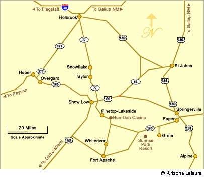
Show Low Arizona Map
Last updated on .
Use this detailed Show Low map and directions guide to plan your trip to one of the most popular destinations in the White Mountains of Arizona. Located in northeastern Arizona, Show Low is easily accessible from Phoenix, Tucson, and surrounding areas, with scenic drives through forested mountain terrain. This map highlights major highways, nearby towns, and key routes into Show Low, helping visitors navigate the region and plan efficient travel to lakes, recreation areas, and outdoor attractions throughout the White Mountains.
This map shows the general location and directions to Show Low, AZ in relation to its sister-towns and communities in the Arizona White Mountains.
Why People Use This Map
Travelers use Show Low maps and directions to plan road trips, identify the best routes through the White Mountains, and locate nearby lakes, campgrounds, and recreation areas. With its higher elevation and cooler temperatures, Show Low attracts visitors year-round, and having a reliable map helps ensure smooth travel whether arriving for a summer vacation, fishing trip, or winter getaway. The map also makes it easier to explore nearby destinations and scenic routes, making it an essential tool for planning a trip to this popular Northern Arizona destination.
Driving Directions to Show Low
- From Phoenix (AZ-87 → AZ-260)
- From Tucson (I-10 → US-60 → AZ-77)
- From Flagstaff (I-40 → AZ-77)
How to Get to Show Low
From Phoenix: Take AZ-87 north toward Payson, then continue east on AZ-260 through the Mogollon Rim country toward Show Low. This is one of the most common routes from the Phoenix area and offers scenic mountain views along the way.
From Tucson: Take I-10 west/northwest toward the Phoenix area, then connect with US-60 or AZ-77 depending on your preferred route. Travelers can continue through Globe and the Salt River Canyon area before reaching Show Low.
From Flagstaff: Take I-40 east toward Holbrook, then follow AZ-77 south through Snowflake and Taylor toward Show Low. This route provides access from northern Arizona and Interstate 40.
Travel Times to Show Low
- From Phoenix: About 3 to 3.5 hours, depending on traffic, weather, and starting point in the Valley.
- From Tucson: About 4 to 5 hours, depending on route selection and road conditions.
- From Flagstaff: About 2.5 to 3 hours by way of I-40 and AZ-77.
- From Payson: About 1.5 to 2 hours east on AZ-260.
- From Holbrook: About 1 to 1.25 hours south on AZ-77.
Scenic Stops Along the Way
- Payson: A popular stop between Phoenix and Show Low with restaurants, fuel, shopping, and access to Rim Country attractions.
- Mogollon Rim: A scenic high-country region along the route from Payson to Show Low, known for forest views, lakes, overlooks, and cooler temperatures.
- Salt River Canyon: A dramatic canyon drive often used by travelers coming from Tucson, Globe, or the US-60 corridor.
- Snowflake and Taylor: Historic White Mountains communities along AZ-77 north of Show Low.
Things To Do Near Show Low
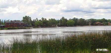
- Visit nearby lakes such as Show Low Lake, Fool Hollow Lake, Rainbow Lake, and Woodland Lake
- Explore White Mountains towns including Pinetop-Lakeside, Snowflake, Taylor, and Springerville
- Go fishing, boating, kayaking, hiking, camping, or wildlife watching
- Use Show Low as a base for scenic drives through Arizona’s high country
- Visit in summer for cooler mountain weather or in winter for nearby snow recreation
Show Low Map FAQ
Where is Show Low Arizona?
Show Low is located in northeastern Arizona in the White Mountains region, along major routes including AZ-260 and AZ-77.
How far is Show Low from Phoenix?
Show Low is about 175 miles from Phoenix, with a typical drive time of about 3 to 3.5 hours depending on traffic, weather, and starting point.
What is the best route from Phoenix to Show Low?
A common route from Phoenix to Show Low is AZ-87 north to Payson, then AZ-260 east through the Mogollon Rim area into Show Low.
How far is Show Low from Tucson?
Show Low is generally about 4 to 5 hours from Tucson by road, depending on the chosen route and conditions.
What towns are near Show Low?
Nearby towns include Pinetop-Lakeside, Snowflake, Taylor, Lakeside, Heber-Overgaard, and Springerville.
Related Show Low Interest
Show Low Arizona
Average Temps-Weather Show Low
Show Low RV Campgrounds
Show Low Map & Directions
Show Low RV Parks
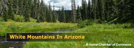
Beautiful White Mountains In Arizona
White Mountains
Map & Directions
Little Colorado River
Weather & Climate
Alpine Arizona
Heber/Overgaard
Pinetop-Lakeside
Payson Arizona
About Show Low
Snowflake/Taylor
Springerville Arizona
Greer Arizona
Popular Area Lakes
Rainbow Lake
White Mountains Lakes
Big Lake
Hawley Lake
Show Low Lake
Crescent Lake
Woodland Lake
Luna Lake
Becker Lake
Fool Hollow Lake
Lyman Lake


