

Snowbowl Scenic Drive Near Flagstaff, Arizona
Updated by AZ Leisure Staff Writers on
Snowbowl Scenic Drive is a beautiful mountain drive from Flagstaff into the San Francisco Peaks, climbing through ponderosa pine and aspen forests to Arizona Snowbowl. The route provides access to mountain scenery, seasonal wildflowers, fall colors and views across Northern Arizona. Nearby Humphreys Peak, at 12,633 feet, is the highest point in Arizona, while Arizona Snowbowl provides skiing in winter and seasonal mountain activities during warmer months.
- About The Scenic Drive
- Best Time To Drive
- Arizona Snowbowl Gondola
- Directions & Route
- Road Conditions & Travel Tips
- Snowbowl Scenic Drive Map
- FAQ
About The Snowbowl Scenic Drive
The approximately 15-mile one-way drive from Flagstaff follows US 180 and Snowbowl Road into the San Francisco Peaks. After leaving the city, the route climbs through increasingly dense mountain forest before reaching the Arizona Snowbowl base area at about 9,500 feet elevation. Along the way, changing vegetation, mountain meadows and viewpoints provide a dramatic contrast to Arizona's lower-elevation desert landscapes.
Best Time To Drive Snowbowl Road
Each season brings a different character to the Snowbowl Scenic Drive. Spring and summer bring green mountain meadows and seasonal wildflowers, while autumn is especially popular when groves of aspen turn shades of yellow and gold. Winter transforms the San Francisco Peaks with snow and brings the ski season at Arizona Snowbowl. Weather changes quickly at this elevation, so road and mountain conditions should always be checked before making the drive.
Snowbowl Scenic Drive Directions
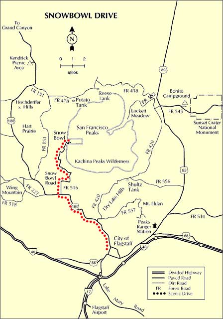
From Flagstaff, travel northwest on US 180 for approximately 7 miles, then turn onto Snowbowl Road toward Arizona Snowbowl. Snowbowl Road climbs roughly 8 additional miles to the resort base area, making the drive about 15 miles one way from Flagstaff. Allow extra time for sightseeing, mountain traffic and changing weather conditions.
Road Conditions & Travel Tips
Snowbowl Road is paved, but mountain driving conditions can change rapidly, especially during winter storms. Snow, ice and heavy mountain traffic can affect travel, and traction requirements or temporary restrictions may occur during severe weather. Before leaving Flagstaff, check current weather, road conditions and Arizona Snowbowl operating information.
- Check Conditions First: Mountain weather can differ significantly from conditions in downtown Flagstaff.
- Allow Extra Time: Traffic can be heavier during ski season and peak fall-color weekends.
- Prepare For Elevation: The drive climbs from Flagstaff to roughly 9,500 feet at the Snowbowl base area.
- Watch For Wildlife: Elk, deer and other wildlife may cross mountain roads.
- Winter Driving: Carry appropriate winter equipment and comply with posted traction requirements when snow or ice is present.
- Stay On Established Roads: Respect posted closures, private areas and National Forest regulations.
Arizona Snowbowl Scenic Gondola
During seasonal operations, visitors can extend the scenic-drive experience with a ride on the Arizona Snowbowl Scenic Gondola. The gondola climbs to approximately 11,500 feet and offers expansive views across Northern Arizona, including the surrounding San Francisco Peaks, distant volcanic terrain and, on especially clear days, the Grand Canyon. Gondola schedules, operating days and activities vary by season and weather, so check current Arizona Snowbowl information before visiting.
Wildlife Along The Drive
The forests and meadows of the San Francisco Peaks provide habitat for a variety of Northern Arizona wildlife. Visitors may encounter elk, mule deer, wild turkey and smaller forest animals along the route. Watch for wildlife near the roadway, particularly around dawn and dusk, and observe animals from a safe distance.
Snowbowl Scenic Drive Information
- Coconino National Forest - Current forest information, alerts and recreation guidance
- Arizona Snowbowl - Current mountain conditions, activities and operating information
Nearest Lodging & Accommodations
Consider Flagstaff Hotels and Motels, Bed and Breakfast Inns, RV Parks or Vacation Home Rentals.
Snowbowl Scenic Drive Map
Snowbowl Scenic Drive FAQ
How long is the Snowbowl Scenic Drive?
The drive from Flagstaff to the Arizona Snowbowl base area is approximately 15 miles one way, using US 180 and Snowbowl Road.
Where does the Snowbowl Scenic Drive begin?
The route begins in Flagstaff by following US 180 northwest from the city and then turning onto Snowbowl Road toward the San Francisco Peaks and Arizona Snowbowl.
How high does Snowbowl Road climb?
Snowbowl Road climbs into the San Francisco Peaks to the Arizona Snowbowl base area at roughly 9,500 feet elevation.
What is the best time of year to drive Snowbowl Road?
The drive is scenic in every season, but fall is especially popular for golden aspen foliage. Summer offers green forests and mountain activities, while winter provides snowy scenery and access to Arizona Snowbowl's ski area when conditions permit.
Can you see fall colors on the Snowbowl Scenic Drive?
Yes. Aspen groves along the San Francisco Peaks typically provide some of the Flagstaff area's most popular fall-color scenery. The timing and intensity of fall color varies from year to year.
Is Snowbowl Road paved?
Yes. The main route to Arizona Snowbowl is paved, although snow, ice, storms and other mountain conditions can affect travel.
Can you ride a gondola at Arizona Snowbowl?
Arizona Snowbowl offers seasonal Scenic Gondola Rides to approximately 11,500 feet. Operations are weather dependent and schedules vary, so visitors should verify current availability before traveling.
Can you see the Grand Canyon from Arizona Snowbowl?
On especially clear days, distant views from high elevations at Arizona Snowbowl can include the Grand Canyon. Visibility depends on weather and atmospheric conditions.
Flagstaff High Country
Enjoy Cool Flagstaff
Flagstaff Arizona
Map & Directions
Weather & Climate
Miles to Arizona Cities
Picture Gallery
Distance To Attractions
About Flagstaff AZ
Lakes Near Flagstaff
Blue Ridge Reservoir
Upper Lake Mary
Mormon Lake
Kinnikinick Lake
Ashurst Lake
Flagstaff Fishing
Scenic Drives
Oak Creek Canyon
Arizona Route 66
Peaks Loop Drive
Schultz Pass Road
Snowbowl Scenic Drive
Things To Do
Scenic Railways
Cliff Castle Casino
Snow Skiing
Flagstaff Camping
Flagstaff Museums
Area Attractions
Lake Powell
Wupatki Ruins
San Francisco Peaks
Grand Canyon
Walnut Canyon
Humphreys Peak
Meteor Crater
Sunset Crater
Historic Downtown
Arizona Snowbowl
Lowell Observatory
Arboretum of Flagstaff
Where To Stay
Cabin Rentals
RV Parks & Campgrounds
Bed and Breakfast
Conifer House
Aspen Inn
Flagstaff Articles
Kids Snow Play
Dress For Flagstaff
Nearby Cities
Williams Arizona















