Spillway RV Campground Near Payson AZ
Spillway RV and Tent Camping Campground is one of the most popular camping areas in Arizona. Of course it is located next to Woods Canyon Lake one of the mor popular lakes in Arizona. The campground is located in a heavily forested area on the edge of the Mogollon Rim at an elevation of 7.500 feet, you can expect cool and refreshing temperatures during summer months.

Woods Canyon Lake has a water surface of 55 acres, but there has been many trophy-size trout caught at the lake. There is a country store at the lake that rents boats and has a battery charging station for those bring their own trolling motors. Boats are limited to 8 HP electric motors. if you do not plan on camping overnight, the Rocky Point Day Picnic Area is near the store. Parking is fee-based.
There is a dump station about a mile back up the road as you exit the Woods Canyon Recreation Area. A functional phone is available at the store. The Rim Visitor Information Center is located at State Route 260 and the Rim Road. There are fee-based showers located at nearby Canyon Point Campground about 5 miles east of the visitor information center.
Campground Amenities and Information
Concessionaire. On site during the season.
Fees. Nominal.
Season. May 15 through September.
Camping. Tent camping and RV camping.
Campsites. 26 units plus a 25 person group site.
RVs and Trailers. Limited to 16 feet maximum.
Reservations. Camping sites must be reserved.
Amenities. Grills, picnic tables, toilets, campfire rings. drinking water, and dump station nearby. Wood is available for sale from the camp host.
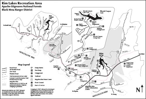
Campground Location Map
Directions From Payson AZ. Take Highway 260 northeast toward Heber. Turn left (west) onto Forest Road 300 directly across from the Rim Visitor Information Station. Follow FR 300 for 5 miles. Turn right at Woods Canyon Road fro another 0.75 miles, Spillway will be on the right.
Keep in mind that Spillway Campground sets at an elevation of 7,500 feet which is 2,000 feet higher than the town of Payson, Arizona, so the temperatures at the camping sites will be much cooler.
GPS Info. (Latitude, Longitude):
34.33194, -110.93639
34°19'55"N, 110°56'11"W
More Campground Information
Apache-Sitgreaves National Forests
Black Mesa Ranger District
(928) 535-7300
Reservations
877-444-5777
Related Payson Interest
Payson Arizona
Aspen RV Campground
Canyon Point RV Campground
Christopher Creek
Christopher Creek RV Campground
Houston Mesa RV Campground
Mogollon RV Campground
Payson Area Map
Payson Area RV Parks
Payson Bed and Breakfasts
Payson Cabin Rentals
Payson Pictures
Payson RV Campgrounds
Payson Vacation Rentals
Rim RV Campground Payson
Sinkhole RV Campground
Spillway RV Campground
Tonto Natural Bridge Park
Strawberry Arizona
Weather In Payson
Beautiful White Mountains In Arizona
White Mountains
Map & Directions
Little Colorado River
Weather & Climate
Alpine Arizona
Heber/Overgaard
Pinetop/Lakeside
Payson Arizona
About Show Low
Snowflake/Taylor
Springerville Arizona
Greer Arizona
Popular Area Lakes
Rainbow Lake
White Mountains Lakes
Big Lake
Hawley Lake
Show Low Lake
Crescent Lake
Woodland Lake
Luna Lake
Becker Lake
Fool Hollow Lake
Lyman Lake


