

Oak Creek Arizona In Oak Creek Canyon
Last updated on .
Oak Creek in northern Arizona is one of the most scenic and refreshing natural destinations in the state, flowing through the heart of Oak Creek Canyon between Sedona and Flagstaff. Known for its crystal-clear waters, shaded canyon walls, and lush forest surroundings, Oak Creek offers a unique high-country escape from the desert heat. The creek winds through red rock formations and pine forests, creating a diverse landscape ideal for outdoor recreation, sightseeing, and relaxation. Whether you’re exploring hiking trails, enjoying a quiet picnic, or simply taking in the scenery, Oak Creek delivers one of Arizona’s most memorable natural experiences.
Oak Creek is a crystal clear stream that over millions of years formed Oak Creek Canyon as it dropped steeply from the top of the rim near Flagstaff, Arizona down through Sedona, Arizona. Oak Creek meanders through the narrow gorge of steep canyon walls.
 © Mike Koopsen
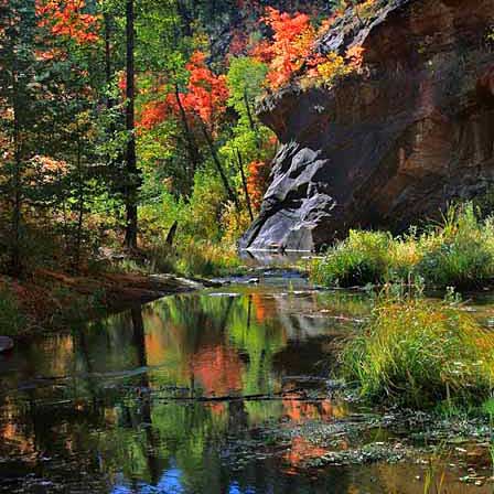
The waters of Oak Creek descend about 2,000 feet through the lush forested and winding landscape through Sedona. The greenery of oak, sycamore, cottonwood, and aspen trees, colorful foliage of springtime wildflowers or the golden leaves against red rock canyon walls is breathtaking.
Why Visit Oak Creek In Arizona
Visitors come to Oak Creek for its combination of natural beauty, accessibility, and year-round outdoor opportunities. The creek is especially popular for swimming, wading, and trout fishing, with numerous access points throughout Oak Creek Canyon. Shaded areas and cool flowing water make it a favorite summer destination, while fall brings vibrant foliage and stunning photography conditions. With nearby campgrounds, scenic drives along Highway 89A, and easy access to Sedona’s red rock attractions, Oak Creek provides a perfect blend of adventure and relaxation for families, hikers, anglers, and photographers alike.
At various points the creek moves rapidly and can become a torrent of overflowing waters during heavy rains and snow melt-off from the higher elevations. At other spots, the creek slows to a crawl and even pools into swimming holes.
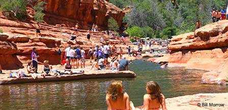
Oak Creek could be one of the most scenic fishing spots in Arizona and is stocked with Rainbow Trout. The famous Slide Rock is about mid-way between the top of the canyon and Sedona. Slide Rock is a natural water-slide where enthusiasts slide down the creek and then get out, trek back up and slide down again and again.
The creek is lined on both sides with cabins, lodges, cottages and bed and breakfast inns that are romantically set among some great campgrounds, fishing spots, swimming holes and hiking trails like the West Fork Oak Creek Trail. There are several pull-off view points along the creek which runs about 14 miles from the canyon rim to Sedona.
Best Things To Do Along Oak Creek
Oak Creek offers a mix of outdoor recreation, scenic beauty, and cool canyon settings near Sedona. Visitors can enjoy swimming, wading, trout fishing, hiking, photography, camping, and scenic drives through Oak Creek Canyon. The creek is especially popular during warmer months when shaded water access provides a refreshing escape from the Arizona heat.
- Swimming & Wading: Popular at Slide Rock State Park and other creek access areas.
- Trout Fishing: Oak Creek is known for scenic stream fishing in Oak Creek Canyon.
- Hiking: Nearby trails include West Fork Trail and other Sedona-area routes.
- Photography: Red rock cliffs, reflections, fall colors, and flowing water create excellent photo opportunities.
- Picnicking: Several canyon picnic areas provide shaded places to relax near the creek.
Swimming, Fishing & Hiking Along Oak Creek
Oak Creek is one of the most popular outdoor recreation areas near Sedona because it combines water, shade, canyon scenery, and convenient access from Highway 89A. Swimming and wading are common during warmer months, while anglers look for trout in suitable sections of the creek. Hikers often use Oak Creek Canyon as a starting point for shaded canyon walks, scenic overlooks, and longer trails such as West Fork Oak Creek Trail.
- Swimming Areas: Slide Rock State Park and Grasshopper Point are among the most recognized warm-weather destinations.
- Fishing Areas: Oak Creek offers stream fishing opportunities in scenic canyon surroundings.
- Hiking Access: West Fork Trail, creekside paths, and canyon viewpoints are popular with hikers.
- Family Outings: Picnic areas, campgrounds, and creek access points make Oak Creek a favorite family destination.
Best Places Along Oak Creek By Season
Spring (March – May)
- West Fork Trail Access Area – Peak spring runoff creates flowing creek crossings and lush greenery along the canyon floor.
- Call of the Canyon (Bootlegger Day Use Area) – Mild weather and steady water flow make this a great early-season picnic and hiking spot.
- Midgley Bridge Area – Spring light and higher water levels create excellent photography conditions below the bridge.
- Encinoso Picnic Area – Quiet setting with blooming vegetation and easy creek access before summer crowds arrive.
Summer (June – August)
- Slide Rock State Park – One of the most popular cooling spots with natural rock slides and refreshing creek pools.
- Grasshopper Point Picnic Area – Deep water and shaded cliffs make this a top destination for swimming and relaxing.
- Pine Flat Campground Area – Cooler temperatures along the creek with shaded access for wading and family outings.
- Cave Springs Campground Area – Forested setting with easy access to Oak Creek, ideal for camping and escaping the heat.
Fall (September – November)
- West Fork Trail Access Area – One of Arizona’s best fall color locations, with golden leaves reflecting in the creek.
- Midgley Bridge Area – Excellent vantage point for autumn photography with red rock and fall foliage contrast.
- Call of the Canyon Area – Crisp temperatures and colorful canyon scenery make this a peaceful fall destination.
- Encinoso Picnic Area – Less crowded and ideal for enjoying fall colors along quieter stretches of Oak Creek.
Winter (December – February)
- Oak Creek Vista Area (Upper Canyon) – Snow-dusted canyon views and quieter surroundings create a unique winter experience.
- West Fork Trail Access Area – Light snow and icy creek edges provide dramatic winter photography opportunities.
- Pine Flat Campground Area – Peaceful winter setting with fewer visitors and calm creek conditions.
- Midgley Bridge Area – A great spot to capture winter contrasts between red rock, snow, and flowing water.
Oak Creek Facts
Location: Oak Creek Canyon begins about 14 miles south of Flagstaff on paved roads.
Access: Drive south from Flagstaff on US 89A. About 14 miles down the road you reach the edge of Oak Creek Canyon before it drops nearly a thousand feet down a series of switchbacks to the canyon floor and continues for 13 more miles beside cool, clear Oak Creek. You can turnaround and go up the canyon for a different perspective.
Campground Season: Early Spring through mid-Fall (or first snowfall). Manzanita Campground is open all year.
Attractions: Fishing, Swimming, Slide Rock State Park, Hiking, Biking, Sightseeing, Wildlife Viewing and Photography.
Facilities: 5 developed campgrounds, 5 picnic areas, hiking trails, developed services and Interpretation at Slide Rock and Red Rock State Park.
Notes: During late spring and the summer months, Oak Creek Canyon can become very crowded when temperatures become ideal. The campgrounds fill early during these periods. Note that glass containers are not permitted at Slide Rock State Park.
FAQ
Where is Oak Creek located?
Oak Creek is located in northern Arizona, flowing through Oak Creek Canyon between Flagstaff and Sedona.
Can you swim in Oak Creek?
Yes. Swimming and wading are popular in several areas along Oak Creek, especially near Slide Rock State Park and other canyon access points.
Is Oak Creek good for fishing?
Yes. Oak Creek is known for scenic stream fishing and is often associated with trout fishing in Oak Creek Canyon.
What are the best things to do along Oak Creek?
Popular activities include swimming, fishing, hiking, camping, picnicking, scenic driving, photography, and visiting Slide Rock State Park.
When is the best time to visit Oak Creek?
Spring, summer, and fall are the most popular times to visit Oak Creek, while winter can offer quieter scenery and occasional snow in the canyon.
Is Oak Creek near Sedona?
Yes. Oak Creek flows through Oak Creek Canyon and continues through the Sedona area, making it one of the most accessible natural attractions near Sedona.
Are there campgrounds near Oak Creek?
Yes. Oak Creek Canyon has developed campgrounds and picnic areas near the creek, with some areas operating seasonally.
Is Oak Creek Canyon crowded?
Oak Creek Canyon can become crowded during late spring, summer, weekends, and holidays, especially near swimming areas, campgrounds, and popular trailheads.
Additional Sedona Area Information
Map & Directions Oak Creek Trail
Oak Creek Canyon Map & Directions
Oak Creek Canyon Photos By Koopsen
Oak Creek Canyon Vista Point
Sedona Aerial Photos By Koopsen
Sedona Winter Photos By Koopsen
Verde Canyon Railroad
The Wonder Of Sedona & Oak Creek
Sedona-Oak Creek Canyon
Sedona Arizona
Oak Creek Canyon
Arizona Route 66
Map & Directions
Weather & Climate
Sedona Pictures
Things To Do
Public Golf Courses
Grand Canyon Tours
West Fork Trail
Desert Canyon Drive
Sedona Museums
Events & Festivals
Horseback Riding
Area Attractions
Palatki Indian Ruins
Montezuma Castle
Montezuma Well
Grand Canyon South Rim
Sycamore Canyon
Slide Rock State Park
Grand Canyon Railway
Chapel of the Holy Cross
Oak Creek
Nearby Towns
Flagstaff Arizona
Jerome Arizona
Cornville Arizona
Williams Arizona
Cottonwood Arizona
Sedona Articles
Native American History
Vortex Visions
Mystical Vortexes
Enchantment Resort
Credit The Sinagua
Where To Stay
Cabins & Lodges
RV Parks & Campgrounds
Bed and Breakfast
Sedona Vacation Rentals
Sedona Timeshares















