

Slide Rock State Park Oak Creek Canyon Arizona
Last updated on .
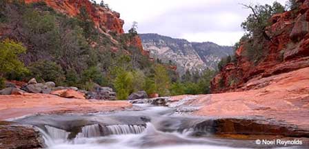
Slide Rock State Park is one of the most popular outdoor attractions near Sedona, Arizona, located along scenic Highway 89A in Oak Creek Canyon. Known for its natural sandstone water slide, cool swimming holes, red rock canyon scenery, picnic areas, short hiking trails, and historic apple orchard setting, Slide Rock is a favorite summer destination for families, swimmers, photographers, and visitors exploring Oak Creek Canyon.
Slide Rock State Park is located about 7 miles north of Sedona, Arizona along Highway 89A in Oak Creek Canyon which has been named One of America's Most Scenic Drives. If you love picnicking and water recreation in astoundingly beautiful landscape, this is a natural attraction you don't want to miss.
Why Visit Slide Rock State Park & Oak Creek Canyon
Visitors come to Slide Rock State Park for a rare combination of natural water recreation and classic Sedona red rock scenery. The park offers a refreshing escape during warm weather, with flowing Oak Creek water, smooth sandstone slides, picnic areas, shaded creekside spaces, historic orchard views, and easy access to some of the most scenic parts of Oak Creek Canyon.
Best Time To Go To Slide Rock State Park
- Spring: Mild weather, blooming trees, and flowing creek conditions make spring a scenic time to visit.
- Summer: Summer is the most popular season for swimming and sliding, but visitors should expect crowds and limited parking.
- Fall: Cooler temperatures, apple harvest season, and colorful Oak Creek Canyon scenery make fall especially enjoyable.
- Winter: Cold temperatures and occasional snow create beautiful canyon scenery, though swimming is generally not practical.
Things To Do At Slide Rock State Park
- Slide The Natural Rock Chute: Enjoy the smooth sandstone water slide that gives the park its name.
- Swim In Oak Creek: Cool off in natural pools along one of Arizona’s most scenic canyon creeks.
- Picnic Along The Creek: Use picnic areas and shaded spaces for family outings and relaxing breaks.
- Explore Short Trails: Walk creekside paths, orchard areas, and scenic viewpoints around the park.
- Photography: Capture red rock cliffs, flowing water, fall colors, and historic orchard scenery.
- Visit The Historic Orchard: Learn about the Pendley Homestead and the apple-growing history of the area.
Fishing Near Slide Rock State Park
- Oak Creek: Fishing is available in sections of Oak Creek near Slide Rock State Park where regulations allow.
- Rainbow Trout: Oak Creek is known for trout fishing, including stocked rainbow trout in nearby areas.
- Arizona Fishing License: A valid Arizona fishing license is required for anglers age 10 and older.
- Quiet Creek Sections: Anglers often look for less crowded stretches away from the main swimming areas.
- Seasonal Conditions: Fishing quality can vary depending on water flow, weather, crowds, and seasonal stocking.
Slide Rock Safety Tips
Rocks in and around Oak Creek can be very slippery, and water levels can change quickly after storms. Wear sturdy water shoes or old tennis shoes, supervise children closely, avoid glass containers, and never jump into shallow or unclear water. During monsoon season, watch weather conditions carefully because flash flooding can occur in Oak Creek Canyon.
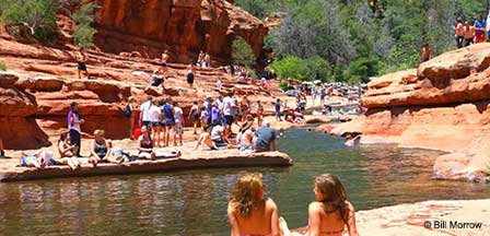
Get ready for a blast for the whole family. When summer arrives, lucky folks from the desert cities flock to this cool paradise. "Slide Rock" gets its name after a natural water slide that gradually descends down Oak Creek. Rocks and boulders that have been worn smooth over millions of years by flowing water line the bottom of the creek forming a slippery natural water chute.
The fun and excitement never ends as swimmers briskly slide down the chute until it levels out and then they trek back to the starting point and do it again and again. There are places where cliff jumping into deep water pools is a blast. If you plan on swimming and sliding down Slide Rock, wear old tennis shoes and a pair of old cutoff jeans. It's wise to take a change of clothes.
Picnic Recreation At Slide Rock
It is beautiful here with red rock cliffs and canyon walls rising from the creek. Slide Rock State Park is more fun than just frolicking in the water. The park includes picnic tables, restrooms, volleyball courts, and even a market that sells snacks, picnic supplies and even apples that grow in the nearby orchards. Apple tree blossoms arrive in mid-April and apples are harvested in September and October.
Fishing is permitted in Oak Creek that contains Rainbow Trout. A fishing license is required. There are short hiking trails around the creek that meander through unspoiled back country views and the old Pendley homestead built in 1907.
There are cliffs west of the creek that will reward you with views down Oak Creek Canyon. And when you're done chuting the slide, hiking, eating and there is still daylight, swim or just relax in the refreshing water pools along Oak Creek.
What Are The Temperatures at Slide Rock?
Slide Rock Park sits at an elevation of about 4,930 feet creating four distinct seasons. June, July, and August are the warmest months with high temperatures in the high 80s to mid-90s. Reaching 100 degrees is uncommon.
Park visits begin to diminish after Labor Day weekend when lower temperatures signal the beginning of the fall season. Temperatures in late September and November bring highs ranging from the 60s to low 70s.
Winter brings cold weather and snowfall. Swimming in the creek then is only for the daring. When Oak Creek Canyon is blanketed in snow, it becomes a photographers dream. See the Sedona Weather Chart for approximate seasonal temperatures by month. Sedona sets at a slightly lower elevation so the temperatures at Slide Rock will be a few degrees cooler.
Things To Know When Visiting Slide Rock
Nominal fees apply. Normal parks hours are 9:00 AM to 7 PM with last entry into the park at 6:00 PM. Fees and hours are subject to change without notice. Call the Park at (928) 282-3034 to verify.
Expect peak crowds during the summer months. The parking lot can fill by mid-to-late morning. It is possible that access could be temporarily unavailable if too crowded.
Pets and glass containers are prohibited in the swimming areas. Dogs are permitted in other places with leash at all times. Propane, charcoal, and wood fires are prohibited.
Slide Rock State Park
6871 N. Highway 89A
Sedona, Arizona 86336
(928) 282-3034
Slide Rock Map
Includes parking and facilities location. It further explains park rules, guidelines, swimming areas and hiking trail descriptions.
Parking & Fees
Parking fees are charged for entry into Slide Rock State Park and may vary by season and demand. During busy summer weekends and holidays, the parking area can fill quickly by mid-morning, so arriving early is strongly recommended. Fees, hours, and access conditions may change, especially during peak visitation periods or severe weather events.
How To Get To Slide Rock
From Phoenix. Take Interstate 17 North to Highway 179. Take 179 West through Sedona to Highway 89A which will be the entry into Oak Creek Canyon. Slide Rock State Park will be about 7 miles from Sedona AZ. Driving distance from Phoenix is about 110-125 miles.
Driving Distances To Slide Rock State Park
- From Sedona: Approximately 7 miles north of Sedona along Highway 89A through Oak Creek Canyon.
- From Flagstaff: Approximately 28 miles south of Flagstaff, about 40 to 50 minutes depending on traffic.
- From Phoenix: Approximately 115 to 125 miles, about 2 to 2.5 hours depending on route and traffic.
- From Cottonwood: Approximately 23 miles, about 40 to 50 minutes depending on traffic through Sedona.
Nearby Attractions
Visitors to Slide Rock State Park often explore additional attractions throughout Sedona and Oak Creek Canyon including the scenic West Fork Oak Creek Trail, panoramic views from Oak Creek Canyon Vista Point, and the red rock landscapes, shopping, restaurants, hiking trails, and attractions found throughout Sedona Arizona.
Related Reading and Interest
Oak Creek Canyon Map
Oak Creek Canyon Scenic Drive
West Fork Oak Creek Hiking Trail
Sedona Arizona
Oak Creek Canyon Photos
Additional Sedona Area Information
Map & Directions Oak Creek Trail
Oak Creek Canyon Map & Directions
Oak Creek Canyon Photos By Koopsen
Oak Creek Canyon Vista Point
Sedona Aerial Photos By Koopsen
Sedona Winter Photos By Koopsen
Verde Canyon Railroad
FAQ
Where is Slide Rock State Park located?
Slide Rock State Park is located about 7 miles north of Sedona, Arizona along Highway 89A in Oak Creek Canyon.
Can you swim at Slide Rock State Park?
Yes, swimming and sliding in Oak Creek are the most popular activities during warm weather.
When is the best time to visit Slide Rock State Park?
Summer is best for swimming, while spring and fall offer milder weather and beautiful canyon scenery.
Is fishing allowed near Slide Rock State Park?
Fishing is allowed in parts of Oak Creek where regulations permit, and an Arizona fishing license is required.
Does Slide Rock State Park get crowded?
Yes, summer weekends and holidays are very busy, and the parking lot can fill early in the day.
Are pets allowed at Slide Rock State Park?
Pets are allowed in some areas on leash, but they are not allowed in the main swimming and sliding areas.
The Wonder Of Sedona & Oak Creek
Sedona-Oak Creek Canyon
Sedona Arizona
Oak Creek Canyon
Arizona Route 66
Map & Directions
Weather & Climate
Sedona Pictures
Things To Do
Public Golf Courses
Grand Canyon Tours
West Fork Trail
Desert Canyon Drive
Sedona Museums
Events & Festivals
Horseback Riding
Area Attractions
Palatki Indian Ruins
Montezuma Castle
Montezuma Well
Grand Canyon South Rim
Sycamore Canyon
Slide Rock State Park
Grand Canyon Railway
Chapel of the Holy Cross
Oak Creek
Nearby Towns
Flagstaff Arizona
Jerome Arizona
Cornville Arizona
Williams Arizona
Cottonwood Arizona
Sedona Articles
Native American History
Vortex Visions
Mystical Vortexes
Enchantment Resort
Credit The Sinagua
Where To Stay
Cabins & Lodges
RV Parks & Campgrounds
Bed and Breakfast
Sedona Vacation Rentals
Sedona Timeshares


