

Sycamore Canyon Arizona
Last updated on .
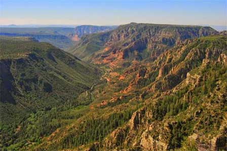 Sycamore Canyon Near Williams, Arizona
Arizona's Remote Red Rock Wilderness
Sycamore Canyon is one of Arizona’s largest and most rugged wilderness areas, stretching between the Williams and Sedona regions through deep red rock gorges, forested plateaus, desert riparian habitat, scenic overlooks, remote hiking trails, and hidden swimming holes. Often described as a quieter alternative to Oak Creek Canyon, Sycamore Canyon offers adventurous travelers outstanding backcountry scenery, wildlife viewing, photography, camping, hiking, and wilderness solitude far from crowded tourist destinations.
No paved roads in Sycamore Canyon. No developed campgrounds. And no motorized vehicles allowed past the entrance, not even bicycles. There is no visitor center. Sycamore Canyon Wilderness may at first seem inhospitable, the adventurous will discover a backcountry paradise.
Wilderness solitude. A true natural habitat, Sycamore Canyon will leave you feeling as though you were the first human to gaze upon its deep gorges, stunning rock formations, rich riparian habitat, swimming holes and even some waterfalls.
Why Visit Sycamore Canyon
Visitors come to Sycamore Canyon for its dramatic red rock landscapes, remote hiking opportunities, secluded swimming areas, diverse wildlife, and peaceful wilderness setting. Sycamore Canyon is Arizona’s second-largest canyon system after the Grand Canyon. Unlike more developed Arizona attractions, Sycamore Canyon delivers a true backcountry experience where travelers can explore rugged trails, scenic overlooks, desert creeks, and forested canyon rims with fewer crowds and a greater sense of isolation.
Things To Do & See Around Sycamore Canyon
- Parsons Trail: One of the canyon’s most popular hikes featuring creek crossings, red rock scenery, and lush riparian habitat.
- Sycamore Rim Trail: A scenic trail that follows portions of the canyon rim with forest views, overlooks, and seasonal pools.
- Swimming Holes: Discover secluded natural pools and creek areas during warmer months.
- Red Rock Photography: Capture colorful canyon walls, rock formations, cliffs, pinnacles, and desert landscapes.
- Wildlife Viewing: Watch for mule deer, black bears, ringtail cats, hawks, rattlesnakes, and other Arizona wildlife.
- Backcountry Camping: Enjoy primitive wilderness camping in remote areas of the canyon.
- Horseback Riding: Explore portions of the wilderness by horseback along rugged backcountry trails.
- Scenic Forest Roads: Drive through remote Coconino National Forest landscapes near the canyon rim.
- Rock Formations and Cliffs: View towering red rock formations, arches, mesas, and deep canyon walls.
- Nearby Sedona Attractions: Combine a Sycamore Canyon visit with nearby Sedona, Oak Creek Canyon, Cottonwood, Clarkdale, or Jerome.
Best Times To Visit Sycamore Canyon
- Spring: One of the best seasons for hiking, flowing creeks, mild temperatures, and green desert vegetation.
- Summer: Warm temperatures make swimming holes and shaded canyon areas popular, though monsoon storms can affect roads and trails.
- Fall: Cooler temperatures and changing canyon vegetation create excellent hiking and photography conditions.
- Winter: Northern portions of the canyon can receive snow while lower elevations remain accessible during milder weather.
About The Sycamore Canyon Wilderness
It is the second largest canyon in Arizona. The Grand Canyon is the largest. Sycamore is a huge 56,000 acres and almost all of it is only accessible by foot or horseback. Backcountry enthusiasts will experience hiking, rock climbing, horseback riding, swimming, fishing and wildlife in one of the country's most stunning yet least visited landscapes.
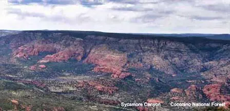
The colorful cliffs, with towering pinnacles, arches, mesas and buttes, will astonish the first time visitor and continue to amaze those who return for even more scenic wonder. Sycamore Canyon provides many outstanding vistas for photographers and artists to capture nature's symphony of color and form. It is as fine an example of Arizona's Red Rocks as the canyon's more famous sister, Oak Creek Canyon to the east.
Sycamore Canyon Wilderness Travel Tips
- Bring Plenty Of Water: Services are extremely limited and desert conditions can quickly cause dehydration.
- Use High Clearance Vehicles: Some forest roads may become rough, muddy, or impassable during storms.
- Prepare For Remote Conditions: Cell service is limited or unavailable in much of the wilderness area.
- Watch Weather Conditions: Flash flooding and monsoon storms can affect trails and creek crossings.
- Practice Leave No Trace: Pack out trash and help preserve the wilderness environment.
Hiking Sycamore Canyon
Sycamore Canyon extends from just south of Williams, Arizona down to Clarkdale and Cottonwood, Arizona which is near Sedona, AZ. Visitors can enter Sycamore from the north or south ends of the canyon depending upon a particular preferred trail. Parsons Trail is perhaps the most hiked trail in the canyon and can be accessed just north of Clarkdale, AZ.
There are 11.3 miles of trail within the designated Wilderness Area with most trails rated as moderate with a few strenuous stretches. Elevation at the forested north area of the canyon is 6,800 feet dropping to 4,800 ft at its lowest point at the south end.
Kelsey Winter Trail, Little L.O. Trail, Dorsey Springs Trail, Taylor Cabin Trail, Winter Cabin Trail, Sycamore Rim Trail and Parsons Trail make up most of the Wilderness Area's trail system and have trailheads located off the Forest Service roads that traverse the canyon.
The Sycamore Rim Trail is most enjoyable during the warmer months as it takes visitors around the canyon's upper rim through deep forests alongside several secluded pools. The canyon's solitude makes these pools the perfect place to jump in and cool down during your summer hike.
The Taylor Cabin Trail gives you the remnants of a real cowboy cabin from the American west. The Parsons Trail is one of the most fascinating as it makes its way through a lush desert riparian habitat.
Forest road access to some trailheads can be quite rough in spots. During the winter, heavy snow on the northern edges of the canyon can make some of the roads impassable. Monsoon season can limit accessibility through the forest roads.
Wilderness Area maps, including hiking and access trails are available from the Coconino Forest Peaks Ranger Station in Flagstaff or from the Red Rocks Ranger District office in Sedona.
Wildlife in Sycamore Canyon
Sycamore Canyon is home to some of the most diverse wildlife in the west. Black bears and mountain lions call the area home, as do more than a few smaller creatures that can join you at your campsite. Rattlesnakes like to take cover in the rocks so use caution when grabbing hold or descending through brush.
At night, in the flicker of your dying fire, you may catch a glimpse of the notorious camp robber, the bandit-masked ringtail cat making off with a bit of tomorrow's lunch.
Getting To Sycamore Canyon
You may get to Sycamore Canyon from a number of highways and forest service roads from both the north and south edges of the canyon. Major access points are off Route 66/FR 231, U.S. 89A, and FR's 152, 152D, 152C, 525, 538E, 538G and 538H. See the map below.
Forest roads are rough and often impassable during bad weather and cross undeveloped thick forests. The area is extremely remote, so be prepared with necessary provisions and rely on experienced hiking partners. There are many areas suitable for camping, but camping guideline requires no camping within 200 feet of natural waterways.
Human waste must be buried at least 200 feet from any natural waters. To keep the wilderness pristine for all to enjoy, pack your trash out with you and do not remove discovered artifacts or deface the natural environment.
Sycamore Canyon Map
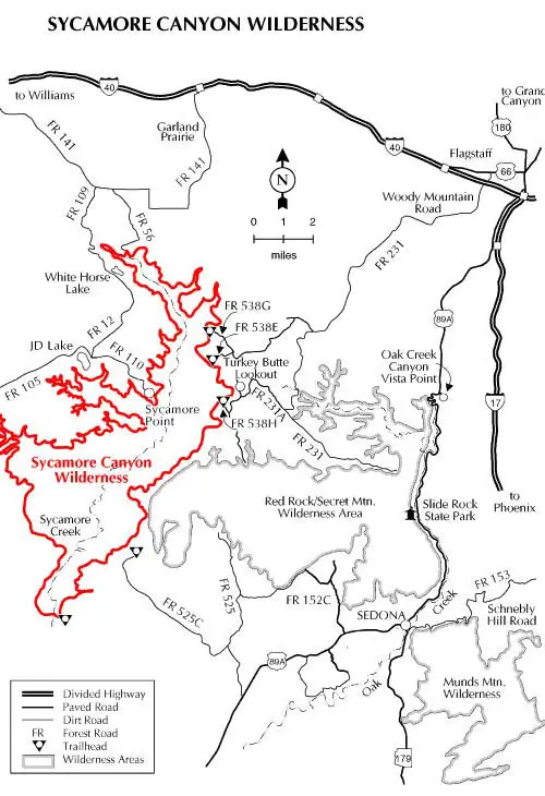 Map courtesy of the NPS
FAQ
Where is Sycamore Canyon Arizona located?
Sycamore Canyon is located between the Williams, Sedona, Clarkdale, and Cottonwood areas of northern Arizona within the Coconino National Forest.
Is Sycamore Canyon worth visiting?
Yes. Sycamore Canyon is one of Arizona’s best wilderness destinations for hiking, solitude, red rock scenery, photography, camping, and outdoor adventure.
What is the best hike in Sycamore Canyon?
Parsons Trail is often considered the canyon’s most popular and scenic hike because of its creek crossings, canyon scenery, and riparian habitat.
Can you camp in Sycamore Canyon?
Yes. Primitive wilderness camping is allowed in many areas, though visitors should follow Leave No Trace practices and wilderness regulations.
Are there swimming holes in Sycamore Canyon?
Yes. Seasonal creek pools and swimming holes can often be found in portions of the canyon during warmer months.
When is the best time to visit Sycamore Canyon?
Spring and fall are usually the best times to visit because of milder temperatures and better hiking conditions.
How large is Sycamore Canyon Wilderness?
Sycamore Canyon Wilderness covers roughly 56,000 acres and is considered one of Arizona’s largest wilderness canyon areas outside of the Grand Canyon.
Are vehicles allowed inside Sycamore Canyon Wilderness?
Motorized vehicles and bicycles are not permitted beyond designated wilderness access points.
For More Information
Coconino National Forest
Red Rock District
8375 State Route 179
Sedona, Arizona 86341
928-203-2900
Flagstaff District
1824 S. Thompson Street
Flagstaff, AZ 86001
928- 527-3600
Related Sycamore Canyon Interest
Sycamore Canyon
Parsons Trail Sycamore Canyon
Additional Sedona Area Information
Map & Directions Oak Creek Trail
Oak Creek Canyon Map & Directions
Oak Creek Canyon Photos By Koopsen
Oak Creek Canyon Vista Point
Sedona Aerial Photos By Koopsen
Sedona Winter Photos By Koopsen
Verde Canyon Railroad
The Wonder Of Sedona & Oak Creek
Sedona-Oak Creek Canyon
Sedona Arizona
Oak Creek Canyon
Arizona Route 66
Map & Directions
Weather & Climate
Sedona Pictures
Things To Do
Public Golf Courses
Grand Canyon Tours
West Fork Trail
Desert Canyon Drive
Sedona Museums
Events & Festivals
Horseback Riding
Area Attractions
Palatki Indian Ruins
Montezuma Castle
Montezuma Well
Grand Canyon South Rim
Sycamore Canyon
Slide Rock State Park
Grand Canyon Railway
Chapel of the Holy Cross
Oak Creek
Nearby Towns
Flagstaff Arizona
Jerome Arizona
Cornville Arizona
Williams Arizona
Cottonwood Arizona
Sedona Articles
Native American History
Vortex Visions
Mystical Vortexes
Enchantment Resort
Credit The Sinagua
Where To Stay
Cabins & Lodges
RV Parks & Campgrounds
Bed and Breakfast
Sedona Vacation Rentals
Sedona Timeshares


