

Grand Canyon North Rim Map & Driving Directions
Updated by AZ Leisure Staff Writers on
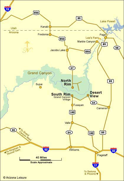
The Grand Canyon North Rim is reached by Arizona Highway 67 from Jacob Lake in northern Arizona. The North Rim entrance station is approximately 30 miles south of Jacob Lake, with the developed canyon-rim area about 14 miles farther into the park. From Flagstaff, the drive is approximately 207 miles one way.
Highway 67 and the North Rim are seasonal. The main visitor season generally runs from May 15 through October 15, and Highway 67 normally closes to vehicle traffic for winter beginning December 1. During the 2026 season, visitors should also expect limited services and no potable water from park water systems.
- North Rim Map
- Quick Route Facts
- From Flagstaff
- From Zion National Park
- From Jacob Lake
- From The South Rim
- Seasonal Road Access
- Driving Tips
- FAQ
Grand Canyon North Rim Map
Grand Canyon North Rim Driving Quick Facts
- Main access road: Arizona Highway 67
- Highway 67 begins: At Jacob Lake on U.S. Highway 89A
- Jacob Lake to entrance station: Approximately 30 miles
- Entrance station to canyon rim: Approximately 14 additional miles
- Flagstaff to North Rim: Approximately 207 miles
- South Rim to North Rim: Approximately 212 miles by road
- Main season: Approximately May 15 through October 15
- Winter vehicle access: Highway 67 normally closes beginning December 1
- 2026 road status: Highway 67 is open for the current season
- 2026 potable water: Not available from park water systems
Directions From Jacob Lake To The North Rim
From Jacob Lake, turn south onto Arizona Highway 67 and continue approximately 30 miles to the North Rim entrance station. The developed canyon-rim area is approximately another 14 miles south beyond the entrance station.
Highway 67 is the only paved highway into the developed North Rim area. Fuel, food and other services are limited, so travelers should arrive prepared, especially during the 2026 recovery season.
Directions From Zion National Park To The North Rim
From Zion National Park, travel east on Utah Highway 9 toward Mount Carmel Junction, then continue toward Kanab, Utah. From Kanab, follow U.S. Highway 89A south toward Jacob Lake, Arizona. At Jacob Lake, turn south onto Arizona Highway 67 and continue approximately 44 miles to the developed North Rim area.
Directions From Flagstaff To The North Rim
From Flagstaff, travel north on U.S. Highway 89 to Bitter Springs. Turn west onto U.S. Highway 89A and continue through Marble Canyon toward Jacob Lake. At Jacob Lake, turn south onto Arizona Highway 67 and continue to the Grand Canyon North Rim.
The total one-way driving distance from Flagstaff to the North Rim is approximately 207 miles, or 333 kilometers.
Driving From The South Rim To The North Rim
The North Rim and South Rim may appear close across the canyon, but there is no bridge or direct road connecting them. The driving route is approximately 212 miles and generally requires about five hours.
From the South Rim, drive east on Arizona Highway 64 through the East Entrance at Desert View to Cameron. Continue north on U.S. Highway 89 to Bitter Springs, then take U.S. Highway 89A west through Marble Canyon to Jacob Lake. From Jacob Lake, follow Arizona Highway 67 south to the North Rim.
North Rim Seasonal Road Access
The Grand Canyon North Rim has a much shorter driving season than the South Rim because of its higher elevation and winter snowfall. The main visitor season generally runs from May 15 through October 15.
Arizona Highway 67 normally closes to all vehicle traffic for winter beginning December 1 and remains closed until spring road conditions allow reopening. Travelers visiting near the beginning or end of the season should check current National Park Service and Arizona Department of Transportation road conditions before leaving.
For the 2026 season, Highway 67 and all paved roads inside the North Rim have reopened following the 2025 Dragon Bravo Fire, but visitor services remain limited.
2026 North Rim Travel Conditions
The North Rim is open for the 2026 season, but visitors should expect limited services during recovery from the 2025 Dragon Bravo Fire. There is no potable water available from park water systems, so travelers should carry adequate drinking water and food.
The North Rim General Store is operating seasonally and sells bottled water, dry goods and grab-and-go food. The North Rim gas station provides seasonal pay-at-the-pump gasoline and diesel.
Always check current North Rim conditions shortly before departure because weather, fire recovery work or other hazards can cause temporary road or trail restrictions.
Grand Canyon North Rim Driving Tips
- Fill your fuel tank before beginning remote sections of the drive.
- Bring plenty of drinking water, especially during the 2026 season.
- Do not rely on continuous cell-phone service in northern Arizona.
- Check Highway 67 status before traveling during spring or late fall.
- Allow extra time for stops at Marble Canyon, Navajo Bridge and scenic viewpoints along U.S. 89A.
- Watch for wildlife, especially deer and bison, along Highway 67.
- Avoid driving remote forest roads as shortcuts unless you have current road-condition information.
- Carry warm clothing because North Rim elevations can be cool even when lower desert areas are hot.
- Check weather forecasts for thunderstorms, snow or other rapidly changing conditions.
- Remember that North Rim services are much more limited than those at the South Rim.
Grand Canyon North Rim Map & Directions FAQ
How Do You Get To The Grand Canyon North Rim?
The developed North Rim is reached by Arizona Highway 67 from Jacob Lake, Arizona. Jacob Lake is located along U.S. Highway 89A.
How Far Is Jacob Lake From The North Rim?
The North Rim entrance station is approximately 30 miles south of Jacob Lake on Highway 67. The actual canyon rim is another 14 miles beyond the entrance station.
How Far Is The North Rim From Flagstaff?
The Grand Canyon North Rim is approximately 207 miles from Flagstaff by road.
How Far Is The North Rim From The South Rim?
The driving distance between the Grand Canyon South Rim and North Rim is approximately 212 miles because vehicles must travel around the canyon.
Is Highway 67 Open To The North Rim?
Highway 67 is open for the 2026 North Rim season. It normally closes to vehicle traffic for winter beginning December 1 and reopens in spring when conditions permit.
Can You Drive Directly From The South Rim To The North Rim?
No. There is no road or bridge directly across the Grand Canyon. Drivers must travel around the eastern end of the canyon through Cameron, Bitter Springs, Marble Canyon and Jacob Lake.
What Highway Goes To The North Rim?
Arizona Highway 67 is the paved highway leading from Jacob Lake to the developed Grand Canyon North Rim.
Can You Drive To The North Rim In Winter?
No. Highway 67 normally closes to all vehicle traffic for winter beginning December 1 and remains closed until seasonal road conditions allow reopening.
Is There Gas At The Grand Canyon North Rim?
Seasonal pay-at-the-pump gasoline and diesel are available at the North Rim service station during the main visitor season, but travelers should still begin the drive with adequate fuel.
Is There Drinking Water At The North Rim In 2026?
Potable water is not available from park water systems during the 2026 season. Visitors should bring drinking water, although bottled water is sold at the seasonal General Store while it is operating.
The Spectacular Grand Canyon
Related Grand Canyon Interest
Grand Canyon National Park
Average Temperatures South Rim
Bright Angel Trail
Desert View Watchtower
Grand Canyon Camping
Grand Canyon Desert View Map
Grand Canyon Pictures By Koopsen
Grand Canyon Mule Ride
Grand Canyon Rafting
Grand Canyon South Rim Trail
Grand Canyon Winter Pictures By Koopsen
Grandview Point South Rim
Havasu Falls Pictures
Havasupai Indians
Lipan Point South Rim
Mather Point South Rim
Moran Point South Rim
Navajo Point South Rim
North Rim Map
Robert Body Grand Canyon Pictures
Shoshone Point South Rim
South Rim Grand Canyon Directions
South Rim Hours & Entrance Fees
Grand Canyon Summer Hiking
Trail Of Time South Rim
West Rim Map
Yaki Point Grand Canyon
Yavapai Point Geology Museum















