

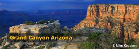
Navajo Point At The Grand Canyon South Rim
Updated by AZ Leisure Staff Writers on
Navajo Point is the highest developed overlook on the Grand Canyon South Rim at 7,461 feet above sea level. Located along Desert View Drive just west of Desert View, the viewpoint offers sweeping vistas across the eastern Grand Canyon, excellent views north along the Colorado River and one of the best distant perspectives of the historic Desert View Watchtower.
The overlook is easily reached by private vehicle and is especially popular at sunset, when low-angle light brings out the reds, oranges and shadows of the canyon walls. Its proximity to Desert View also makes Navajo Point an easy stop for travelers entering or leaving Grand Canyon National Park through the East Entrance.
- Navajo Point Quick Facts
- What You Can See
- Desert View Watchtower
- Photography
- 1956 Aviation Memorial
- Location & Access
- Parking & Facilities
- Desert View Drive Map
- Visitor Tips
- Photo Gallery
- FAQ
Navajo Point Grand Canyon Quick Facts
- Location: Desert View Drive, Grand Canyon South Rim
- Elevation: 7,461 feet
- Distinction: Highest developed overlook on the South Rim
- Access: Private vehicles permitted when Desert View Drive is open
- Parking: Available at the viewpoint
- Best known for: Colorado River views and Desert View Watchtower views
- Watchtower: Visible to the east from the overlook
- Colorado River: Visible far below and to the north
- Sunset: One of the most popular times to visit
- Nearby stop: Desert View
- Road: Arizona State Route 64 / Desert View Drive
What Can You See From Navajo Point?
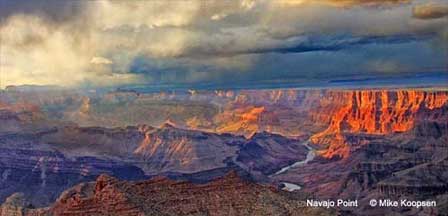
Navajo Point provides panoramic views west across the Grand Canyon and a long view north along the Colorado River. The broad overlook gives visitors a strong sense of the canyon's depth and scale while revealing numerous cliffs, mesas and distant formations.
To the east, the Desert View Watchtower stands prominently above the rim. Looking west, visitors can continue along Desert View Drive toward Lipan Point, Moran Point, Grandview Point and other South Rim overlooks.
Photography At Navajo Point
Navajo Point is especially photogenic during early morning and late afternoon, when low-angle sunlight emphasizes the canyon's layered cliffs, shadows and colors. Sunset is particularly popular because the viewpoint faces broadly west across the canyon.
Wide-angle lenses work well for expansive canyon scenes, while longer focal lengths can isolate the Colorado River, distant formations and Desert View Watchtower. Cloudy or stormy weather can also produce dramatic light and rapidly changing conditions.
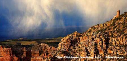
View Of Desert View Watchtower From Navajo Point
One of Navajo Point's distinctive features is its excellent view of Desert View Watchtower rising above the South Rim to the east. Architect Mary Colter designed the stone tower, which opened in 1933 and has become one of the Grand Canyon's most recognizable landmarks.
Navajo Point sits slightly lower than the upper observation deck of the Watchtower, even though Navajo Point itself is the highest developed natural overlook on the South Rim.
1956 Grand Canyon Aviation Accident Memorial
Navajo Point is also the location of a stone memorial and plaque commemorating the 1956 collision of TWA Flight 2 and United Airlines Flight 718 over the Grand Canyon. The June 30, 1956 accident killed all 128 people aboard the two aircraft.
The disaster became an important event in U.S. aviation history and contributed to major changes in the nation's air traffic control system. Visitors should treat the memorial as a place of remembrance while enjoying the surrounding overlook.
Navajo Point Location & Access
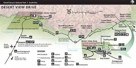
Navajo Point is located along Arizona State Route 64, also known as Desert View Drive, on the eastern section of the Grand Canyon South Rim. It is just west of the Desert View developed area and Desert View Watchtower.
Desert View Drive extends approximately 23 miles between Grand Canyon Village and Desert View and is normally open to private vehicles throughout the year unless temporarily closed because of snow or other road conditions.
The East Entrance is located beyond Desert View to the east, so Navajo Point should not be described as only one-half mile from the park entrance.
Navajo Point Parking & Facilities
Parking is available directly at Navajo Point, making it an easy roadside stop along Desert View Drive. National Park Service information notes that access is suitable for passenger vehicles and a limited number of smaller RVs and campers.
Navajo Point itself does not provide the full range of visitor services available at nearby Desert View. Restrooms, a market, park store and other services are available at the Desert View developed area a short drive to the east.
Desert View Drive Map
Navajo Point Visitor Tips
- Allow at least 15 to 30 minutes for the overlook and longer for photography.
- Visit near sunset for dramatic western light across the canyon.
- Bring water, especially during warm weather.
- Use caution near canyon edges and remain behind barriers where provided.
- Keep children closely supervised near the rim.
- Carry layers because wind and temperatures can change quickly at 7,461 feet.
- Check road conditions before traveling during winter storms.
- Look east for excellent views of Desert View Watchtower.
- Watch for rafts on the Colorado River far below the viewpoint.
- Combine Navajo Point with Desert View, Lipan Point and Moran Point along the same scenic drive.
Navajo Point Photo Gallery
These photographs are by Mike Koopsen and may not be republished. Fine art prints are available through Mike Koopsen Fine Art Prints.
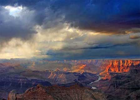 View From Navajo Point. © Mike Koopsen
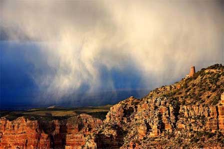 View of Watchtower From Navajo Point. © Mike Koopsen
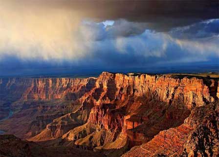 View From Navajo Point. © Mike Koopsen
More Grand Canyon South Rim Information
- Desert View Watchtower
- Desert View Scenic Drive
- Grand Canyon East Entrance
- Lipan Point
- Moran Point
- Grand Canyon South Rim Weather
- Grand Canyon RV Parks & Campgrounds
- Grand Canyon Pictures
Next Overlooks Along Desert View Drive
To The West: Lipan Point
To The East: Desert View
Navajo Point Grand Canyon FAQ
Where Is Navajo Point At The Grand Canyon?
Navajo Point is located along Desert View Drive on the eastern portion of the Grand Canyon South Rim, just west of Desert View.
What Is The Elevation Of Navajo Point?
Navajo Point is 7,461 feet above sea level.
Is Navajo Point The Highest Point On The South Rim?
Navajo Point is the highest developed natural overlook on the South Rim. The upper observation deck of nearby Desert View Watchtower is slightly higher.
Can You Drive To Navajo Point?
Yes. Navajo Point is directly accessible from Desert View Drive by private vehicle when road conditions permit.
Is There Parking At Navajo Point?
Yes. Parking is available at the overlook for passenger vehicles and a limited number of smaller RVs and campers.
Can You See The Colorado River From Navajo Point?
Yes. Navajo Point provides expansive views north along the Colorado River far below the South Rim.
Can You See Desert View Watchtower From Navajo Point?
Yes. Navajo Point offers one of the best distant views of Desert View Watchtower to the east.
Is Navajo Point Good For Sunset?
Yes. Navajo Point is a popular sunset viewpoint because of its broad western view across the Grand Canyon.
What Is The Memorial At Navajo Point?
A stone memorial and plaque at Navajo Point commemorate the 1956 midair collision of TWA Flight 2 and United Airlines Flight 718 over the Grand Canyon.
Is Navajo Point Open In Winter?
Desert View Drive is normally open to private vehicles throughout the year, but snow and ice can cause temporary closures during winter weather.
The Spectacular Grand Canyon
Related Grand Canyon Interest
Grand Canyon National Park
Average Temperatures South Rim
Bright Angel Trail
Desert View Watchtower
Grand Canyon Camping
Grand Canyon Desert View Map
Grand Canyon Pictures By Koopsen
Grand Canyon Mule Ride
Grand Canyon Rafting
Grand Canyon South Rim Trail
Grand Canyon Winter Pictures By Koopsen
Grandview Point South Rim
Havasu Falls Pictures
Havasupai Indians
Lipan Point South Rim
Mather Point South Rim
Moran Point South Rim
Navajo Point South Rim
North Rim Map
Robert Body Grand Canyon Pictures
Shoshone Point South Rim
South Rim Grand Canyon Directions
South Rim Hours & Entrance Fees
Grand Canyon Summer Hiking
Trail Of Time South Rim
West Rim Map
Yaki Point Grand Canyon
Yavapai Point Geology Museum















