


Grand Canyon South Rim Trail
Updated by AZ Leisure Staff Writers on
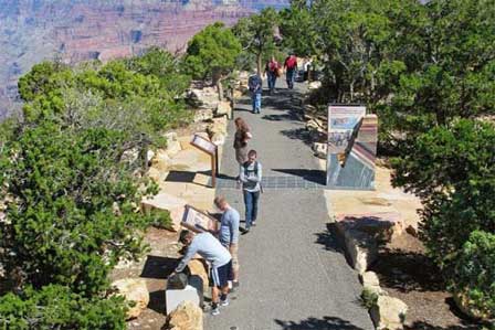 Trail of Time On Rim Trail. Credit: NPS
The Grand Canyon Rim Trail is one of the easiest ways to experience sweeping South Rim views without descending into the canyon. The trail extends approximately 12 miles from Pipe Creek Vista east of Grand Canyon Village to Hermits Rest on the west, connecting major overlooks, museums, historic areas and shuttle stops along the way. Visitors can walk a short section, combine walking with the free shuttle system or spend several hours exploring the rim at their own pace.
- Rim Trail Overview
- Trail Route & Distance
- Best Rim Trail Sections
- Shuttle Access
- Accessibility
- Trail Of Time
- Water & Restrooms
- Best Time To Walk
- Rim Trail Safety
- FAQ
Grand Canyon Rim Trail Overview
- Location: Grand Canyon National Park South Rim
- Length: Approximately 12 miles from Pipe Creek Vista to Hermits Rest
- Difficulty: Generally easy to moderate, depending on the section
- Trail surface: Mixture of paved and unpaved trail
- Elevation: Approximately 7,000 feet at the South Rim
- Best feature: Continuous access to Grand Canyon viewpoints without descending into the canyon
- Shuttle access: Available at numerous points along the route
- Dogs: Check current National Park Service pet regulations before bringing a pet
- Bicycles: Bicycles are not permitted on the pedestrian Rim Trail, although nearby designated Greenway routes accommodate bicycles
Grand Canyon Rim Trail Route And Distance
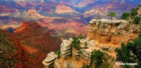
The Rim Trail follows the South Rim from Pipe Creek Vista through the Grand Canyon Visitor Center and Mather Point area, past Yavapai Geology Museum and Grand Canyon Village, and west along Hermit Road to Hermits Rest.
The complete route is approximately 12 miles, but most visitors walk only part of it. Short sections between major viewpoints can take less than an hour, while longer walks may require several hours. The approximately 7-mile section from Grand Canyon Village toward Hermits Rest alone generally requires three hours or more on foot.
Because shuttle stops are located along much of the route, walkers can easily create one-way hikes instead of retracing their steps.
Best Sections Of The Grand Canyon Rim Trail
Pipe Creek Vista To Mather Point
This approximately 1.3-mile paved section provides broad canyon views and convenient access to the Grand Canyon Visitor Center. It works especially well for visitors looking for a relatively short walk with shuttle access nearby.
Mather Point To Yavapai Geology Museum
This popular section follows the canyon rim for approximately 0.7 mile and connects two of the South Rim's most visited locations. It also leads toward the interpretive Trail of Time.
Yavapai Geology Museum To Grand Canyon Village
The approximately 1.3-mile Trail of Time overlaps this portion of the Rim Trail and uses exhibits and rock samples to interpret the Grand Canyon's geologic history.
Grand Canyon Village To Hermits Rest
The western Rim Trail follows Hermit Road for roughly seven miles and connects scenic overlooks including Trailview, Maricopa, Powell, Hopi, Mohave, Monument Creek Vista and Pima Point before reaching Hermits Rest.
Using The South Rim Shuttle With The Rim Trail
The free Grand Canyon shuttle system makes it easy to combine walking with bus transportation. Visitors can walk one section of the Rim Trail, board a shuttle at a nearby stop and continue to another viewpoint or return toward their starting area.
The Hermits Rest Route is especially useful along the western portion of the trail. During most of the year when Hermit Road is closed to private vehicles, the shuttle provides access to scenic overlooks between Grand Canyon Village and Hermits Rest.
Shuttle routes and seasonal schedules change during the year, so check the current National Park Service schedule before planning a point-to-point walk.
Rim Trail Accessibility
Accessibility varies by section of the Rim Trail. Several developed areas near the Grand Canyon Visitor Center, Mather Point, Yavapai Point and Grand Canyon Village have paved trail sections, but portions farther west along Hermit Road include dirt surfaces, grades and steps.
The section between Monument Creek Vista and Pima Point is paved and accessible, while other portions of the Hermit Road Rim Trail are not considered accessible. Visitors with mobility concerns should check the current South Rim accessibility information and choose individual trail segments accordingly.
Grand Canyon shuttle buses can accommodate many wheelchairs, and accessibility permits may be available for visitors who have difficulty using the regular shuttle system.
Trail Of Time On The Grand Canyon Rim Trail
The Trail of Time is an interpretive section of the Rim Trail between Yavapai Geology Museum and Grand Canyon Village. The approximately 1.3-mile experience uses exhibits, rock samples and distance markers to help visitors visualize the immense span of Grand Canyon geologic history.
Walking west from Yavapai Geology Museum takes visitors backward through geologic time while maintaining frequent views into the canyon. The Trail of Time is especially useful for visitors who want to combine an easy rim walk with an introduction to Grand Canyon geology.
Water And Restrooms Along The Rim Trail
Water and restroom availability varies along the Rim Trail. Developed visitor areas such as the Grand Canyon Visitor Center, Yavapai Geology Museum and Grand Canyon Village provide services, while facilities are much more limited along Hermit Road.
Carry drinking water even on shorter walks, especially during warm weather. For longer western sections toward Hermits Rest, bring enough water and snacks for the entire planned walk rather than assuming services will be available between viewpoints.
Best Time To Walk The Grand Canyon Rim Trail
Spring - March Through May
- Cool temperatures can make longer walks comfortable.
- Snow and ice may remain after late-season storms.
- Bring layers because conditions can change quickly.
Summer - June Through August
- Start early or walk later in the day to avoid the strongest afternoon heat and sun.
- Carry water, snacks and sun protection.
- Watch for afternoon thunderstorms and lightning.
Fall - September Through November
- Cooler temperatures often make this an excellent season for longer walks.
- Days become shorter later in the season.
- Early winter storms are possible.
Winter - December Through February
- The South Rim remains open, but snow and ice may cover portions of the trail.
- Traction devices may be useful after winter storms.
- Dress for freezing temperatures and changing conditions.
Grand Canyon Rim Trail Safety Tips
- Stay on established trails and behind railings where they are provided.
- Keep a safe distance from unprotected canyon edges.
- Carry water, snacks and sun protection even for relatively easy rim walks.
- Remember that walking at approximately 7,000 feet elevation can feel more strenuous than expected.
- Use extra caution on snow or ice during winter.
- Move away from exposed viewpoints when thunderstorms and lightning approach.
- Do not rely on cellular service for navigation or emergency planning.
- Check current trail, weather and shuttle conditions before starting a longer walk.
Frequently Asked Questions About The Grand Canyon Rim Trail
How long is the Grand Canyon Rim Trail?
The continuous South Rim Trail is approximately 12 miles from Pipe Creek Vista to Hermits Rest.
Is the Grand Canyon Rim Trail difficult?
Most sections are relatively easy compared with trails that descend into the canyon, but distance, elevation, sun exposure and some unpaved or graded sections can make longer walks more demanding.
Do you have to walk the entire Rim Trail?
No. Most visitors walk selected portions of the trail and use the free shuttle system to connect viewpoints or return to their starting area.
Is the Rim Trail paved?
Much of the eastern and developed portion is paved, but several western sections along Hermit Road are unpaved or include grades and steps.
Is the Grand Canyon Rim Trail wheelchair accessible?
Some portions are accessible, particularly developed paved areas, but accessibility varies considerably by section. The Monument Creek Vista to Pima Point section is one specifically identified accessible portion along Hermit Road.
Where does the Rim Trail start and end?
The continuous trail extends from Pipe Creek Vista on the eastern side of the developed South Rim area to Hermits Rest on the west.
What is the Trail of Time?
The Trail of Time is an approximately 1.3-mile interpretive section of the Rim Trail between Yavapai Geology Museum and Grand Canyon Village that explains Grand Canyon geology and geologic time.
Can you use the shuttle with the Rim Trail?
Yes. The free South Rim shuttle system is one of the easiest ways to combine shorter walks with transportation between major viewpoints and developed areas.
How long does it take to walk from Grand Canyon Village to Hermits Rest?
The Rim Trail between the Village area and Hermits Rest is roughly seven miles, and the National Park Service recommends allowing three hours or more for the walk.
Is the Rim Trail open in winter?
The South Rim remains open year-round, but snow and ice may affect trail conditions during winter storms.
More Grand Canyon South Rim Hiking And Planning
- Trail Of Time
- Bright Angel Trail
- Grand Canyon Summer Hiking
- Grand Canyon South Rim
- Mather Point
- Yavapai Point & Geology Museum
- Grand Canyon Weather & Climate
- Grand Canyon Map & Directions
- Grand Canyon Pictures
Related Reading and Information
Download The Rim Trail Brochure
The Spectacular Grand Canyon
Related Grand Canyon Interest
Grand Canyon South Rim Trail
Grand Canyon National Park
Average Temperatures South Rim
Bright Angel Trail
Desert View Watchtower
Grand Canyon Camping
Grand Canyon Desert View Map
Grand Canyon Pictures By Koopsen
Grand Canyon Mule Ride
Grand Canyon Rafting
Grand Canyon Winter Pictures By Koopsen
Grandview Point South Rim
Havasu Falls Pictures
Havasupai Indians
Lipan Point South Rim
Mather Point South Rim
Moran Point South Rim
Navajo Point South Rim
North Rim Map
Robert Body Grand Canyon Pictures
Shoshone Point South Rim
South Rim Grand Canyon Directions
South Rim Hours & Entrance Fees
Grand Canyon Summer Hiking
Trail Of Time South Rim
West Rim Map
Yaki Point Grand Canyon
Yavapai Point Geology Museum















